National Register of Historic Places listings in Rutherford County, North Carolina

Last updated
Map all coordinates using: OpenStreetMap  ·  Google Maps
Download coordinates as: KML  ·  GPX
North Carolina Map Highlighting Rutherford County.PNG

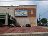
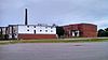
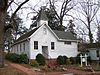
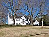
This list includes properties and districts listed on the National Register of Historic Places in Rutherford County, North Carolina. Click the "Map of all coordinates" link to the right to view a Google map of all properties and districts with latitude and longitude coordinates in the table below. [1]

National Register of Historic Places federal list of historic sites in the United States

The National Register of Historic Places (NRHP) is the United States federal government's official list of districts, sites, buildings, structures, and objects deemed worthy of preservation for their historical significance. A property listed in the National Register, or located within a National Register Historic District, may qualify for tax incentives derived from the total value of expenses incurred preserving the property.

Rutherford County, North Carolina County in the United States

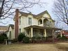
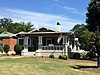
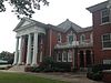
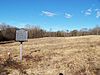
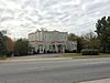
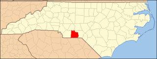
Rutherford County is a county located in the southwestern area of the U.S. state of North Carolina. As of the 2010 census, the population was 67,810. Its county seat is Rutherfordton.

Contents

Current listings

This National Park Service list is complete through NPS recent listings posted May 11, 2018. [2]
[3] Name on the Register [4] Image Date listed [5] Location City or town Description
1 Alexander Manufacturing Company Mill Village Historic District
Alexander Manufacturing Company Mill Village Historic District Alexander Mills School.jpg
Alexander Manufacturing Company Mill Village Historic District
May 15, 2008
(#08000413)
Roughly bounded by Victory and Wilson Drs. and Allen and S. Broadway Sts.
35°18′37″N81°51′22″W / 35.31017°N 81.856064°W / 35.31017; -81.856064 (Alexander Manufacturing Company Mill Village Historic District)
Forest City
2 Bechtler Mint Site Upload image April 14, 1997
(#97000316)
342 Gilboa Church Rd. [6]
35°24′49″N81°58′16″W / 35.4135616°N 81.971046°W / 35.4135616; -81.971046 (Bechtler Mint Site)
Rutherfordton
3 Bostic Charge Parsonage
Bostic Charge Parsonage Bostic Charge Parsonage.jpg
Bostic Charge Parsonage
August 28, 2012
(#12000580)
149 Old Sunshine Rd.
35°21′54″N81°50′03″W / 35.365125°N 81.834167°W / 35.365125; -81.834167 (Bostic Charge Parsonage)
Bostic
4 Carrier Houses
Carrier Houses Carrier-McBrayer House.jpg
Carrier Houses
June 19, 1992
(#92000681)
415 and 423 N. Main St.
35°22′11″N81°57′25″W / 35.369722°N 81.956944°W / 35.369722; -81.956944 (Carrier Houses)
Rutherfordton
5 Carson-Andrews Mill and Ben F.W. Andrews House
Carson-Andrews Mill and Ben F.W. Andrews House Ben F.W. Andrews House.jpg
Carson-Andrews Mill and Ben F.W. Andrews House
June 4, 2008
(#08000495)
Both sides of NC 1007, east, south, and west of the junction with NC 1796
35°24′37″N81°50′13″W / 35.410297°N 81.836886°W / 35.410297; -81.836886 (Carson-Andrews Mill and Ben F.W. Andrews House)
Washburn
6 Cliffside Public School
Cliffside Public School Cliffside School.jpg
Cliffside Public School
January 26, 1998
(#97001667)
1 N. Main St.
35°14′48″N81°46′10″W / 35.246667°N 81.769444°W / 35.246667; -81.769444 (Cliffside Public School)
Cliffside
7 Cool Springs High School
Cool Springs High School Cool Springs High School.jpg
Cool Springs High School
July 8, 1999
(#99000813)
382 W. Main St.
35°20′19″N81°51′58″W / 35.338611°N 81.866111°W / 35.338611; -81.866111 (Cool Springs High School)
Forest City
8 East Main Street Historic District
East Main Street Historic District 317 E. Main Street - Built 1924.jpg
East Main Street Historic District
December 23, 2005
(#05001450)
Roughly along parts of Arlington St., Carolina Ave., N. Magnolia St., S. Magnolia St., E. Main St., and McBrayer Court
35°19′56″N81°51′16″W / 35.332222°N 81.854444°W / 35.332222; -81.854444 (East Main Street Historic District)
Forest City
9 Forest City Baptist Church
Forest City Baptist Church Forest City Baptist Church.JPG
Forest City Baptist Church
September 14, 1989
(#89001417)
301 W. Main St.
35°20′03″N81°52′09″W / 35.334167°N 81.869167°W / 35.334167; -81.869167 (Forest City Baptist Church)
Forest City
10 Fox Haven Plantation
Fox Haven Plantation Fox Haven Plantation.jpg
Fox Haven Plantation
September 14, 1972
(#72000996)
Southwest of Rutherfordton off SR 1157
35°20′53″N82°03′13″W / 35.348056°N 82.053611°W / 35.348056; -82.053611 (Fox Haven Plantation)
Rutherfordton
11 Gilbert Town Historic District
Gilbert Town Historic District Gilbert Town Site.jpg
Gilbert Town Historic District
August 23, 2006
(#06000726)
Along sections of Rock Rd. (NC 1520) and Old Gilbert Town Rd. (NC 1539)
35°24′25″N81°56′37″W / 35.406944°N 81.943611°W / 35.406944; -81.943611 (Gilbert Town Historic District)
Rutherfordton
12 Henrietta-Caroleen High School
Henrietta-Caroleen High School Former Henrietta-Caroleen High School.jpg
Henrietta-Caroleen High School
December 23, 2005
(#05001451)
2527 NC 221A
35°16′28″N81°47′48″W / 35.274444°N 81.796667°W / 35.274444; -81.796667 (Henrietta-Caroleen High School)
Mooresboro
13 James Dexter Ledbetter House
James Dexter Ledbetter House James Ledbetter House.jpg
James Dexter Ledbetter House
June 14, 1982
(#82003511)
Off U.S. Route 74
35°21′11″N81°54′06″W / 35.353056°N 81.901667°W / 35.353056; -81.901667 (James Dexter Ledbetter House)
Forest City
14 George W. Logan House
George W. Logan House George W. Logan House.jpg
George W. Logan House
February 20, 1986
(#86000312)
SR 1555 at U.S. Route 64
35°25′02″N81°53′56″W / 35.417222°N 81.898889°W / 35.417222; -81.898889 (George W. Logan House)
Rutherfordton
15 Main Street Historic District
Main Street Historic District Downtown Rutherfordton.jpg
Main Street Historic District
December 7, 1995
(#95001419)
Roughly bounded by Taylor, Court, Washington, and W. Third Sts.
35°22′04″N81°57′27″W / 35.367778°N 81.9575°W / 35.367778; -81.9575 (Main Street Historic District)
Rutherfordton
16 Main Street Historic District
Main Street Historic District Florence Mill.jpg
Main Street Historic District
February 14, 2002
(#02000017)
Roughly bounded by Blanton Alley, Huntley St., Yarboro St., and Broadway St.; also 186 Mill St.
35°19′59″N81°51′54″W / 35.333056°N 81.865°W / 35.333056; -81.865 (Main Street Historic District)
Forest City 186 Mill represents a boundary increase of June 9, 2004
17 Melton-Davis House
Melton-Davis House Melton-Davis House.jpg
Melton-Davis House
August 29, 2008
(#08000813)
477 DePriest Rd.
35°25′57″N81°48′52″W / 35.432367°N 81.814475°W / 35.432367; -81.814475 (Melton-Davis House)
Bostic
18 Melton-Fortune Farmstead Upload image July 11, 1985
(#85001553)
SR 1006 south of NC 226
35°30′34″N81°45′52″W / 35.509444°N 81.764444°W / 35.509444; -81.764444 (Melton-Fortune Farmstead)
Golden Valley
19 Pine Gables
Pine Gables PINE GABLES, RUTHERFORD COUNTY, NC.jpg
Pine Gables
November 30, 1999
(#99001445)
328 Boys Camp Rd.
35°26′15″N82°13′45″W / 35.4375°N 82.229167°W / 35.4375; -82.229167 (Pine Gables)
Lake Lure
20 Rutherford County Courthouse
Rutherford County Courthouse Rutherford County Courthouse.jpg
Rutherford County Courthouse
May 10, 1979
(#79001749)
Main St. between 2nd and 3rd Sts.
35°22′03″N81°57′28″W / 35.3675°N 81.957778°W / 35.3675; -81.957778 (Rutherford County Courthouse)
Rutherfordton
21 Rutherfordton-Spindale Central High School
Rutherfordton-Spindale Central High School RS Central Middle School.jpg
Rutherfordton-Spindale Central High School
February 3, 1993
(#92001843)
545 Charlotte Rd.
35°21′57″N81°56′42″W / 35.365833°N 81.945°W / 35.365833; -81.945 (Rutherfordton-Spindale Central High School)
Rutherfordton
22 St. Luke's Chapel
St. Luke's Chapel St. Luke's Chapel - Ruthefordton, NC.jpg
St. Luke's Chapel
September 26, 1991
(#91001470)
Junction of Hospital Dr. and Old Twitty Ford Rd.
35°21′41″N81°57′56″W / 35.361389°N 81.965556°W / 35.361389; -81.965556 (St. Luke's Chapel)
Rutherfordton
23 Trinity Lutheran Church
Trinity Lutheran Church St-Johns-Rutherfordton.jpg
Trinity Lutheran Church
March 24, 1972
(#72000997)
702 N. Main St.
35°22′21″N81°57′19″W / 35.3725°N 81.955278°W / 35.3725; -81.955278 (Trinity Lutheran Church)
Rutherfordton
24 Washburn Historic District
Washburn Historic District Washburn House.jpg
Washburn Historic District
February 20, 2002
(#02000056)
2401, 2426, and 2436 Bostic-Sunshine Highway, 1391 and 1392 Andrews Mill Rd., 126-156 and 157 Salem Church Rd.; also 1037 Gun Club Rd.
35°23′42″N81°48′59″W / 35.395°N 81.816389°W / 35.395; -81.816389 (Washburn Historic District)
Bostic 1037 Gun Club represents a boundary increase of January 25, 2006
25 T. Max Watson House
T. Max Watson House T. Max Watson House, Forest City, NC.jpg
T. Max Watson House
October 15, 2001
(#01001110)
297 E. Main St.
35°19′58″N81°51′33″W / 35.332778°N 81.859167°W / 35.332778; -81.859167 (T. Max Watson House)
Forest City
26 West Main Street Historic District
West Main Street Historic District McMurry-Bodie House - Built 1928.jpg
West Main Street Historic District
December 20, 2006
(#06001142)
121 Cool Springs Dr., 343-499 W. Maine St., and 121 Memorial Dr.
35°20′20″N81°52′23″W / 35.338889°N 81.873056°W / 35.338889; -81.873056 (West Main Street Historic District)
Forest City

See also

National Register of Historic Places listings in North Carolina Wikimedia list article

This is a list of structures, sites, districts, and objects on the National Register of Historic Places in North Carolina:

Related Research Articles

National Register of Historic Places listings in Transylvania County, North Carolina Wikimedia list article

This list includes properties and districts listed on the National Register of Historic Places in Transylvania County, North Carolina. Click the "Map of all coordinates" link to the right to view a Google map of all properties and districts with latitude and longitude coordinates in the table below.

National Register of Historic Places listings in Polk County, North Carolina Wikimedia list article

This list includes properties and districts listed on the National Register of Historic Places in Polk County, North Carolina. Click the "Map of all coordinates" link to the right to view a Google map of all properties and districts with latitude and longitude coordinates in the table below.

National Register of Historic Places listings in Perquimans County, North Carolina Wikimedia list article

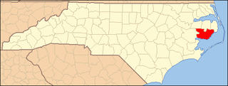
This list includes properties and districts listed on the National Register of Historic Places in Perquimans County, North Carolina. Click the "Map of all coordinates" link to the right to view a Google map of all properties and districts with latitude and longitude coordinates in the table below.

National Register of Historic Places listings in Richmond County, North Carolina Wikimedia list article

This list includes properties and districts listed on the National Register of Historic Places in Richmond County, North Carolina. Click the "Map of all coordinates" link to the right to view a Google map of all properties and districts with latitude and longitude coordinates in the table below.

National Register of Historic Places listings in Anson County, North Carolina Wikimedia list article

This list includes properties and districts listed on the National Register of Historic Places in Anson County, North Carolina. Click the "Map of all coordinates" link to the right to view a Google map of all properties and districts with latitude and longitude coordinates in the table below.

National Register of Historic Places listings in Jones County, North Carolina Wikimedia list article

This list includes properties and districts listed on the National Register of Historic Places in Jones County, North Carolina. Click the "Map of all coordinates" link to the right to view a Google map of all properties and districts with latitude and longitude coordinates in the table below.

National Register of Historic Places listings in Greene County, North Carolina Wikimedia list article

This list includes properties and districts listed on the National Register of Historic Places in Greene County, North Carolina. Click the "Map of all coordinates" link to the right to view a Google map of all properties and districts with latitude and longitude coordinates in the table below.

National Register of Historic Places listings in Mitchell County, North Carolina Wikimedia list article

This list includes properties and districts listed on the National Register of Historic Places in Mitchell County, North Carolina. Click the "Map of all coordinates" link to the right to view a Google map of all properties and districts with latitude and longitude coordinates in the table below.

National Register of Historic Places listings in Cherokee County, North Carolina Wikimedia list article

This list includes properties and districts listed on the National Register of Historic Places in Cherokee County, North Carolina. Click the "Map of all coordinates" link to the right to view an online map of all properties and districts with latitude and longitude coordinates in the table below.

National Register of Historic Places listings in Tyrrell County, North Carolina Wikimedia list article

This list includes properties and districts listed on the National Register of Historic Places in Tyrrell County, North Carolina. Click the "Map of all coordinates" link to the right to view a Google map of all properties and districts with latitude and longitude coordinates in the table below.

National Register of Historic Places listings in Alexander County, North Carolina Wikimedia list article

This list includes properties and districts listed on the National Register of Historic Places in Alexander County, North Carolina, United States. Click the "Map of all coordinates" link to the right to view a Google map of all properties and districts with latitude and longitude coordinates in the table below.

National Register of Historic Places listings in Camden County, North Carolina Wikimedia list article

This list includes properties and districts listed on the National Register of Historic Places in Camden County, North Carolina. Click the "Map of all coordinates" link to the right to view an online map of all properties and districts with latitude and longitude coordinates in the table below.

National Register of Historic Places listings in Clay County, North Carolina Wikimedia list article

This list includes properties and districts listed on the National Register of Historic Places in Clay County, North Carolina. Click the "Map of all coordinates" link to the right to view a Google map of all properties and districts with latitude and longitude coordinates in the table below.

National Register of Historic Places listings in Gates County, North Carolina Wikimedia list article

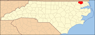
This list includes properties and districts listed on the National Register of Historic Places in Gates County, North Carolina. Click the "Map of all coordinates" link to the right to view a Google map of all properties and districts with latitude and longitude coordinates in the table below.

National Register of Historic Places listings in Hoke County, North Carolina Wikimedia list article

This list includes properties and districts listed on the National Register of Historic Places in Hoke County, North Carolina. Click the "Map of all coordinates" link to the right to view a Google map of all properties and districts with latitude and longitude coordinates in the table below.

National Register of Historic Places listings in Hyde County, North Carolina Wikimedia list article

This list includes properties and districts listed on the National Register of Historic Places in Hyde County, North Carolina. Click the "Map of all coordinates" link to the right to view a Google map of all properties and districts with latitude and longitude coordinates in the table below.

National Register of Historic Places listings in McDowell County, North Carolina Wikimedia list article

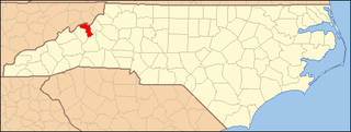
This list includes properties and districts listed on the National Register of Historic Places in McDowell County, North Carolina. Click the "Map of all coordinates" link to the right to view a Google map of all properties and districts with latitude and longitude coordinates in the table below.

National Register of Historic Places listings in Pamlico County, North Carolina Wikimedia list article

This list includes properties and districts listed on the National Register of Historic Places in Pamlico County, North Carolina. Click the "Map of all coordinates" link to the right to view a Google map of all properties and districts with latitude and longitude coordinates in the table below.

National Register of Historic Places listings in Washington County, North Carolina Wikimedia list article

This list includes properties and districts listed on the National Register of Historic Places in Washington County, North Carolina. Click the "Map of all coordinates" link to the right to view a Google map of all properties and districts with latitude and longitude coordinates in the table below.

National Register of Historic Places listings in Yancey County, North Carolina Wikimedia list article

This list includes properties and districts listed on the National Register of Historic Places in Yancey County, North Carolina. Click the "Map of all coordinates" link to the right to view a Google map of all properties and districts with latitude and longitude coordinates in the table below.

References

  1. The latitude and longitude information provided in this table was derived originally from the National Register Information System, which has been found to be fairly accurate for about 99% of listings. For about 1% of NRIS original coordinates, experience has shown that one or both coordinates are typos or otherwise extremely far off; some corrections may have been made. A more subtle problem causes many locations to be off by up to 150 yards, depending on location in the country: most NRIS coordinates were derived from tracing out latitude and longitudes off of USGS topographical quadrant maps created under the North American Datum of 1927 , which differs from the current, highly accurate WGS84 GPS system used by most on-line maps. Chicago is about right, but NRIS longitudes in Washington are higher by about 4.5 seconds, and are lower by about 2.0 seconds in Maine. Latitudes differ by about 1.0 second in Florida. Some locations in this table may have been corrected to current GPS standards.
  2. "National Register of Historic Places: Weekly List Actions". National Park Service, United States Department of the Interior. Retrieved on May 11, 2018.
  3. Numbers represent an ordering by significant words. Various colorings, defined here, differentiate National Historic Landmarks and historic districts from other NRHP buildings, structures, sites or objects.
  4. National Park Service (2008-04-24). "National Register Information System". National Register of Historic Places . National Park Service.
  5. The eight-digit number below each date is the number assigned to each location in the National Register Information System database, which can be viewed by clicking the number.
  6. Rutherford County Tourism Development Authority