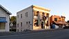
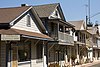
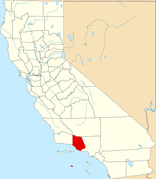
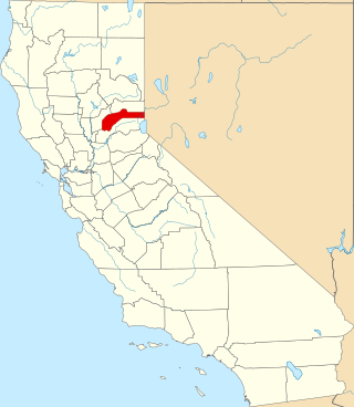
[3] Name on the Register [4] Image Date listed [5] Location City or town Description 1 Alkali Flat Central Historic District Alkali Flat Central Historic District July 26, 1984 (# 84000929 Roughly E and F Sts. between 9th and 12th Sts. 38°35′04″N 121°29′23″W / 38.584444°N 121.489722°W / 38.584444; -121.489722 (Alkali Flat Central Historic District ) Sacramento 2 Alkali Flat North Historic District Alkali Flat North Historic District April 19, 1984 (# 84000933 D and 11th Sts. 38°35′12″N 121°29′16″W / 38.586667°N 121.487778°W / 38.586667; -121.487778 (Alkali Flat North Historic District ) Sacramento 3 Alkali Flat West Historic District Alkali Flat West Historic District July 26, 1984 (# 84000936 E, F, and 8th Sts. 38°35′09″N 121°29′35″W / 38.585833°N 121.493056°W / 38.585833; -121.493056 (Alkali Flat West Historic District ) Sacramento 4 Alta Mesa Farm Bureau Hall Alta Mesa Farm Bureau Hall January 7, 1987 (# 86003577 10195 Alta Mesa Rd. 38°23′13″N 121°13′25″W / 38.387070°N 121.223645°W / 38.387070; -121.223645 (Alta Mesa Farm Bureau Hall ) Wilton The hall was destroyed by fire in 1987, [6] although the detached restroom building still stood as of June 2014. 5 American Cash Apartments-American Cash Store American Cash Apartments-American Cash Store March 22, 2016 (# 16000094 1117-1123 8th St. 38°34′47″N 121°29′48″W / 38.57971°N 121.49671°W / 38.57971; -121.49671 (American Cash Apartments-American Cash Store ) Sacramento 6 American River Grange Hall No. 172 American River Grange Hall No. 172 October 10, 1996 (# 96001079 2720 Kilgore Rd. 38°36′03″N 121°16′28″W / 38.600833°N 121.274444°W / 38.600833; -121.274444 (American River Grange Hall No. 172 ) Rancho Cordova 7 George & Mabel Barr House George & Mabel Barr House October 21, 2019 (# 100004528 2672 Montgomery Way 38°32′48″N 121°28′40″W / 38.5467°N 121.4778°W / 38.5467; -121.4778 (George & Mabel Barr House ) Sacramento 8 Blue Anchor Building Blue Anchor Building February 3, 1983 (# 83001224 1400 10th St. 38°34′33″N 121°29′42″W / 38.575833°N 121.495°W / 38.575833; -121.495 (Blue Anchor Building ) Sacramento 9 Boulevard Park Boulevard Park October 6, 2011 (# 11000705 Roughly bounded by B and H Streets, 20th Street, 22nd Street and 23rd Street 38°34′53″N 121°28′32″W / 38.581389°N 121.475556°W / 38.581389; -121.475556 (Boulevard Park ) Sacramento Historic Residential Suburbs in the United States, 1830-1960 Multiple Property Submission (MPS) 10 Brewster Building Brewster Building August 16, 2000 (# 00000981 201 Fourth St. 38°15′13″N 121°21′42″W / 38.253611°N 121.361667°W / 38.253611; -121.361667 (Brewster Building ) Galt 11 Brewster House Brewster House June 23, 1978 (# 78000740 206 5th St. 38°15′12″N 121°18′14″W / 38.253333°N 121.303889°W / 38.253333; -121.303889 (Brewster House ) Galt 12 Brighton School Brighton School April 3, 1981 (# 81000168 3312 Bradshaw Rd. 38°33′44″N 121°20′09″W / 38.562222°N 121.335833°W / 38.562222; -121.335833 (Brighton School ) Sacramento 13 John Stanford Brown House Upload image July 28, 2004 (# 04000733 13950 CA 160 38°14′53″N 121°30′41″W / 38.248056°N 121.511389°W / 38.248056; -121.511389 (John Stanford Brown House ) Walnut Grove 14 California Governor's Mansion California Governor's Mansion November 10, 1970 (# 70000139 16th and H Sts. 38°34′49″N 121°29′01″W / 38.580278°N 121.483611°W / 38.580278; -121.483611 (California Governor's Mansion ) Sacramento 15 California State Capitol California State Capitol April 3, 1973 (# 73000427 Between 10th and 16th and L and N Sts. 38°34′34″N 121°29′26″W / 38.576111°N 121.490556°W / 38.576111; -121.490556 (California State Capitol ) Sacramento 16 Calpak Plant No. 11 Calpak Plant No. 11 May 17, 1984 (# 84000939 1721 C St. 38°35′09″N 121°28′49″W / 38.585830°N 121.480407°W / 38.585830; -121.480407 (Calpak Plant No. 11 ) Sacramento 17 Capitol Extension District Capitol Extension District May 24, 1984 (# 84000944 Capitol Mall 38°34′37″N 121°29′46″W / 38.576944°N 121.496111°W / 38.576944; -121.496111 (Capitol Extension District ) Sacramento 18 J.C. Carly House J.C. Carly House March 22, 2006 (# 06000143 2761 Montgomery Way 38°32′56″N 121°28′33″W / 38.548889°N 121.475833°W / 38.548889; -121.475833 (J.C. Carly House ) Sacramento 19 Chung Wah Cemetery Chung Wah Cemetery August 21, 1995 (# 95000999 Mormon St. vicinity, near Lake Natoma 38°40′13″N 121°11′43″W / 38.670278°N 121.195278°W / 38.670278; -121.195278 (Chung Wah Cemetery ) Folsom 20 Cohn House Cohn House January 21, 1982 (# 82002228 305 Scott St. 38°40′43″N 121°10′26″W / 38.678611°N 121.173889°W / 38.678611; -121.173889 (Cohn House ) Folsom 21 Coolot Company Building Coolot Company Building September 20, 1978 (# 78000742 812 J St. 38°34′51″N 121°29′41″W / 38.580833°N 121.494722°W / 38.580833; -121.494722 (Coolot Company Building ) Sacramento No longer standing. Originally constructed in 1861 by Leland Stanford . [6] 22 Cranston-Geary House Cranston-Geary House January 23, 1998 (# 97001662 2101 G St. 38°34′47″N 121°28′32″W / 38.579722°N 121.475556°W / 38.579722; -121.475556 (Cranston-Geary House ) Sacramento 23 E. B. Crocker Art Gallery E. B. Crocker Art Gallery May 6, 1971 (# 71000176 216 O St. 38°34′37″N 121°30′18″W / 38.576944°N 121.505°W / 38.576944; -121.505 (E. B. Crocker Art Gallery ) Sacramento 24 DELTA KING DELTA KING March 31, 1978 (# 78000797 1000 Front St. 38°34′58″N 121°30′25″W / 38.582778°N 121.506944°W / 38.582778; -121.506944 (DELTA KING Sacramento Located in Rio Vista when listed on the National Register; moved to Old Sacramento in 1984 and converted to a hotel, restaurant and theater [7] 25 Delta Meadows Site Delta Meadows Site November 5, 1971 (# 71000175 Address Restricted Locke 26 Dunlap's Dining Room Dunlap's Dining Room April 2, 1992 (# 92000308 4322 Fourth Ave. 38°32′52″N 121°27′18″W / 38.547778°N 121.455°W / 38.547778; -121.455 (Dunlap's Dining Room ) Sacramento 27 Eastern Star Hall Eastern Star Hall January 7, 1993 (# 92001757 2719 K St. 38°34′21″N 121°28′22″W / 38.5725°N 121.472778°W / 38.5725; -121.472778 (Eastern Star Hall ) Sacramento 28 William Ehrhardt House William Ehrhardt House July 10, 2003 (# 03000614 Dartmoor Way and Percheron Dr. 38°24′11″N 121°26′54″W / 38.403056°N 121.448333°W / 38.403056; -121.448333 (William Ehrhardt House ) Elk Grove 29 Elk Grove Historic District Elk Grove Historic District March 1, 1988 (# 87002410 8986-9097 Elk Grove Blvd. also School, Gage and Grove Sts. 38°24′33″N 121°21′49″W / 38.409167°N 121.363611°W / 38.409167; -121.363611 (Elk Grove Historic District ) Elk Grove 30 Fire Station No. 6 Fire Station No. 6 April 25, 1991 (# 91000484 3414 4th Ave. 38°33′02″N 121°28′07″W / 38.550556°N 121.468611°W / 38.550556; -121.468611 (Fire Station No. 6 ) Sacramento 31 Firehouse No. 3 Firehouse No. 3 October 29, 1991 (# 91001537 1215 19th St. 38°34′28″N 121°28′52″W / 38.574444°N 121.481111°W / 38.574444; -121.481111 (Firehouse No. 3 ) Sacramento 32 Folsom Depot Folsom Depot February 19, 1982 (# 82002229 200 Wool St. 38°40′45″N 121°10′47″W / 38.679167°N 121.179722°W / 38.679167; -121.179722 (Folsom Depot ) Folsom Southern Pacific Railroad standard design Two-Story Combination Depot No. 22 [8] 33 Folsom Powerhouse Folsom Powerhouse October 2, 1973 (# 73000426 Off Folsom Blvd. in Folsom Lake State Recreation Area 38°40′50″N 121°10′32″W / 38.680556°N 121.175556°W / 38.680556; -121.175556 (Folsom Powerhouse ) Folsom 34 Mary Haley Galarneaux House Mary Haley Galarneaux House February 12, 2001 (# 01000077 922-924 T. St. 38°34′15″N 121°29′56″W / 38.570833°N 121.498889°W / 38.570833; -121.498889 (Mary Haley Galarneaux House ) Sacramento 35 Goethe House Goethe House February 19, 1982 (# 82002230 3731 T St. 38°33′33″N 121°27′34″W / 38.5592°N 121.4594°W / 38.5592; -121.4594 (Goethe House ) Sacramento 36 John T. Greene House John T. Greene House April 15, 1982 (# 82002231 3200 H St. 38°34′31″N 121°27′44″W / 38.575278°N 121.462222°W / 38.575278; -121.462222 (John T. Greene House ) Sacramento 37 Anne Hathaway Cottage Anne Hathaway Cottage October 21, 2019 (# 100004529 2640 Montgomery 38°32′48″N 121°28′43″W / 38.5467°N 121.4786°W / 38.5467; -121.4786 (Anne Hathaway Cottage ) Sacramento 38 Heilbron House Heilbron House December 12, 1976 (# 76000511 704 O St. 38°34′34″N 121°29′54″W / 38.576111°N 121.498333°W / 38.576111; -121.498333 (Heilbron House ) Sacramento 39 Hotel Lenhart Hotel Lenhart September 22, 2021 (# 100006998 1117-1131 9th St. 38°34′44″N 121°29′44″W / 38.5789°N 121.4955°W / 38.5789; -121.4955 (Hotel Lenhart ) Sacramento 40 Hotel Regis Hotel Regis October 29, 1982 (# 82000979 1024-1030 K St 38°34′44″N 121°29′30″W / 38.578889°N 121.491667°W / 38.578889; -121.491667 (Hotel Regis ) Sacramento 41 Hotel Senator Hotel Senator May 30, 1979 (# 79003459 1121 L St. 38°34′40″N 121°29′28″W / 38.577778°N 121.491111°W / 38.577778; -121.491111 (Hotel Senator ) Sacramento 42 Edward P. Howe Jr. House Edward P. Howe Jr. House February 19, 1982 (# 82002232 2215 21st St. 38°33′46″N 121°28′59″W / 38.562778°N 121.483056°W / 38.562778; -121.483056 (Edward P. Howe Jr. House ) Sacramento 43 Hubbard-Upson House Hubbard-Upson House December 2, 1977 (# 77000327 1010 F St. 38°35′04″N 121°29′24″W / 38.5844°N 121.49°W / 38.5844; -121.49 (Hubbard-Upson House ) Sacramento 44 I Street Bridge I Street Bridge April 22, 1982 (# 82002233 CA 16 38°34′39″N 121°30′18″W / 38.5775°N 121.505°W / 38.5775; -121.505 (I Street Bridge ) Sacramento 45 Imperial Theatre Imperial Theatre October 29, 1982 (# 82000980 Market St. 38°14′29″N 121°30′46″W / 38.2414°N 121.5128°W / 38.2414; -121.5128 (Imperial Theatre ) Walnut Grove 46 Indian Stone Corral Upload image April 16, 1975 (# 75000456 Address Restricted Orangevale 47 Isleton Chinese and Japanese Commercial Districts Isleton Chinese and Japanese Commercial Districts March 14, 1991 (# 91000297 Bounded by River Rd. and Union, E and H Sts. 38°09′45″N 121°36′18″W / 38.1625°N 121.605°W / 38.1625; -121.605 (Isleton Chinese and Japanese Commercial Districts ) Isleton 48 J Street Wreck Upload image May 16, 1991 (# 91000562 At the foot of J St., in the Sacramento River 38°35′02″N 121°30′19″W / 38.5839°N 121.5053°W / 38.5839; -121.5053 (J Street Wreck ) Sacramento The remains of a brig used as a warehouse off J Street which sank in 1855. [6] 49 Thomas Jefferson School Thomas Jefferson School March 17, 2021 (# 100006319 1619 N St. 38°34′25″N 121°29′11″W / 38.5735°N 121.4864°W / 38.5735; -121.4864 (Thomas Jefferson School ) Sacramento 50 Joe Mound Upload image October 14, 1971 (# 71000177 Address Restricted Sacramento An Indian village site of the Maidu near present day Discovery Park . No marker on the site. [6] 51 J. Neely Johnson House J. Neely Johnson House September 13, 1976 (# 76000512 1029 F St. 38°35′05″N 121°29′22″W / 38.5847°N 121.4894°W / 38.5847; -121.4894 (J. Neely Johnson House ) Sacramento 52 Theodore Judah School Theodore Judah School July 25, 1997 (# 97000810 3919 McKinley Blvd. 38°34′39″N 121°27′42″W / 38.5775°N 121.4617°W / 38.5775; -121.4617 (Theodore Judah School ) Sacramento 53 Kuchler Row Kuchler Row June 25, 1982 (# 82002234 608-614 10th St. 38°35′03″N 121°29′27″W / 38.5842°N 121.4908°W / 38.5842; -121.4908 (Kuchler Row ) Sacramento 54 Charles Lais House Charles Lais House February 28, 1985 (# 85000358 1301 H St. 38°34′54″N 121°29′13″W / 38.5817°N 121.4869°W / 38.5817; -121.4869 (Charles Lais House ) Sacramento 55 Lawrence Warehouse Lawrence Warehouse January 15, 2014 (# 13001067 1108 R St. 38°34′15″N 121°29′44″W / 38.5708°N 121.4956°W / 38.5708; -121.4956 (Lawrence Warehouse ) Sacramento 56 Libby, McNeil and Libby Fruit and Vegetable Cannery Libby, McNeil and Libby Fruit and Vegetable Cannery March 2, 1982 (# 82002235 1724 Stockton Blvd. 38°33′52″N 121°27′59″W / 38.5644°N 121.4664°W / 38.5644; -121.4664 (Libby, McNeil and Libby Fruit and Vegetable Cannery ) Sacramento 57 Locke Historic District Locke Historic District May 6, 1971 (# 71000174 Bounded on the W by the Sacramento River, on the N by Locke Rd., on the E by Alley St., and on the S by Levee St. 38°15′03″N 121°30′26″W / 38.2508°N 121.5072°W / 38.2508; -121.5072 (Locke Historic District ) Locke 58 Maydestone Apartments Maydestone Apartments September 25, 2012 (# 12000812 1001 15th St. 38°34′42″N 121°29′11″W / 38.5782°N 121.4864°W / 38.5782; -121.4864 (Maydestone Apartments ) Sacramento 59 C. K. McClatchy Senior High School C. K. McClatchy Senior High School November 2, 2001 (# 01001193 3066 Freeport Blvd. 38°33′04″N 121°29′33″W / 38.5511°N 121.4925°W / 38.5511; -121.4925 (C. K. McClatchy Senior High School ) Sacramento 60 McKinley Park McKinley Park October 18, 2018 (# 100003036 Corner of H St. & Alhambra Blvd. 38°34′30″N 121°27′48″W / 38.5751°N 121.4634°W / 38.5751; -121.4634 (McKinley Park ) Sacramento 61 Merchants National Bank of Sacramento Merchants National Bank of Sacramento February 16, 1996 (# 96000108 1015 7th St. 38°34′52″N 121°29′47″W / 38.5811°N 121.4964°W / 38.5811; -121.4964 (Merchants National Bank of Sacramento ) Sacramento 62 Merrium Apartments Upload image September 13, 1990 (# 90001386 1017 14th St. 38°34′41″N 121°29′12″W / 38.5781°N 121.486667°W / 38.5781; -121.486667 (Merrium Apartments ) Sacramento Demolished in the 1990s for expansion of the Sacramento Convention Center . [6] 63 Mesick House Mesick House January 21, 1982 (# 82002236 517 8th St. 38°35′10″N 121°29′34″W / 38.5861°N 121.4928°W / 38.5861; -121.4928 (Mesick House ) Sacramento 64 Mohr and Yoerk Market Mohr and Yoerk Market July 31, 2017 (# 100001385 1029 K St. 38°34′45″N 121°29′34″W / 38.5791°N 121.4928°W / 38.5791; -121.4928 (Mohr and Yoerk Market ) Sacramento 65 Montgomery Way Gateway Historic District Upload image September 29, 2023 (# 100009396 2640-2770 Montgomery Way and 3065, 3071 East Curtis Dr. 38°32′48″N 121°28′41″W / 38.5467°N 121.4781°W / 38.5467; -121.4781 (Montgomery Way Gateway Historic District ) Sacramento 66 Murer House and Gardens Upload image January 19, 2022 (# 100007367 1125 Joe Murer Ct. 38°40′23″N 121°10′56″W / 38.6730°N 121.1821°W / 38.6730; -121.1821 (Murer House and Gardens ) Folsom 67 New Helvetia Historic District New Helvetia Historic District April 4, 2014 (# 14000109 752 Revere St. 38°33′46″N 121°30′17″W / 38.5629°N 121.5048°W / 38.5629; -121.5048 (New Helvetia Historic District ) Sacramento 68 Nisei VFW Post 8985 Upload image October 20, 2020 (# 100005713 1515 4th St. 38°34′35″N 121°30′14″W / 38.5765°N 121.5040°W / 38.5765; -121.5040 (Nisei VFW Post 8985 ) Sacramento 69 Nisenan Village Site Upload image March 21, 1978 (# 78000739 Address Restricted Carmichael 70 North Sacramento School North Sacramento School March 16, 2021 (# 100006320 670 Dixieanne Ave. 38°36′33″N 121°27′05″W / 38.6092°N 121.4514°W / 38.6092; -121.4514 (North Sacramento School ) Sacramento 71 Old Fair Oaks Bridge Old Fair Oaks Bridge September 25, 2006 (# 06000913 Crosses the American River at Bridge St. to American River Pkwy, north of Upper Sunrise Dr. in Gold River 38°38′17″N 121°15′54″W / 38.6381°N 121.265°W / 38.6381; -121.265 (Old Fair Oaks Bridge ) Fair Oaks 72 Old Sacramento Historic District Old Sacramento Historic District October 15, 1966 (# 66000219 Junctions of U.S. 40, 50, 99, and CA 16 and 24 38°34′58″N 121°30′12″W / 38.5828°N 121.5033°W / 38.5828; -121.5033 (Old Sacramento Historic District ) Sacramento 73 Old Tavern Old Tavern September 15, 1983 (# 83001225 2801 Capitol Ave. 38°34′15″N 121°28′09″W / 38.5708°N 121.4692°W / 38.5708; -121.4692 (Old Tavern ) Sacramento 74 PG&E Powerhouse PG&E Powerhouse September 23, 2010 (# 10000774 400 Jibboom St. 38°35′42″N 121°30′18″W / 38.595°N 121.505°W / 38.595; -121.505 (PG&E Powerhouse ) Sacramento 75 Pony Express Terminal Pony Express Terminal October 15, 1966 (# 66000220 1006 2nd St. 38°34′59″N 121°30′11″W / 38.5831°N 121.5031°W / 38.5831; -121.5031 (Pony Express Terminal ) Sacramento Also known as B. F. Hastings Bank Building 76 Rosebud Ranch Rosebud Ranch December 31, 1979 (# 79000521 North of Hood 38°23′08″N 121°30′46″W / 38.3856°N 121.5128°W / 38.3856; -121.5128 (Rosebud Ranch ) Hood 77 Ruhstaller Building Ruhstaller Building January 21, 1982 (# 82002237 900 J St. 38°34′50″N 121°29′38″W / 38.5806°N 121.4939°W / 38.5806; -121.4939 (Ruhstaller Building ) Sacramento Built in 1898, at the corner of 9th and J Street in Sacramento, California, the 20,000 square feet building was built by the behest of Frank F. Ruhstaller and housed The Ruhstaller Brewery offices. Ruhstaller also managed Buffalo Brewery and made the building its headquarters as well. 78 Runyon House Upload image October 27, 2000 (# 00001270 12865 River Rd. 38°17′20″N 121°33′20″W / 38.2889°N 121.5556°W / 38.2889; -121.5556 (Runyon House ) Courtland 79 Sacramento Air Depot Historic District Sacramento Air Depot Historic District January 21, 1992 (# 91001969 McClellan Air Force Base 38°39′33″N 121°23′13″W / 38.6592°N 121.3869°W / 38.6592; -121.3869 (Sacramento Air Depot Historic District ) North Highlands 80 Sacramento Bank Building Sacramento Bank Building January 21, 1982 (# 82002238 3418 Broadway 38°33′07″N 121°28′05″W / 38.5519°N 121.4681°W / 38.5519; -121.4681 (Sacramento Bank Building ) Sacramento 81 Sacramento City Cemetery Sacramento City Cemetery November 5, 2014 (# 14000889 1000 Broadway 38°33′47″N 121°30′04″W / 38.563°N 121.5010°W / 38.563; -121.5010 (Sacramento City Cemetery ) Sacramento 82 Sacramento City Library Sacramento City Library July 30, 1992 (# 92000967 828 I St. 38°34′54″N 121°29′42″W / 38.5817°N 121.4951°W / 38.5817; -121.4951 (Sacramento City Library ) Sacramento part of the California Carnegie Libraries MPS 83 Sacramento Hall of Justice Sacramento Hall of Justice September 24, 1999 (# 99001179 813 6th St. 38°35′01″N 121°29′06″W / 38.5836°N 121.485°W / 38.5836; -121.485 (Sacramento Hall of Justice ) Sacramento 84 Sacramento Junior College Annex and Extensions Sacramento Junior College Annex and Extensions August 22, 1994 (# 94000924 3835 Freeport Blvd. 38°32′28″N 121°29′17″W / 38.5411°N 121.4881°W / 38.5411; -121.4881 (Sacramento Junior College Annex and Extensions ) Sacramento 85 Sacramento Masonic Temple Sacramento Masonic Temple May 17, 2001 (# 01000488 1131 J St. 38°34′55″N 121°29′27″W / 38.5819°N 121.4908°W / 38.5819; -121.4908 (Sacramento Masonic Temple ) Sacramento 86 Sacramento Memorial Auditorium Sacramento Memorial Auditorium March 29, 1978 (# 78000743 16th and J Sts. 38°34′44″N 121°29′05″W / 38.5789°N 121.4847°W / 38.5789; -121.4847 (Sacramento Memorial Auditorium ) Sacramento 87 Sacramento Shops Historic District Upload image March 25, 2024 (# 100010111 111 I Street 38°35′05″N 121°30′17″W / 38.5846°N 121.5046°W / 38.5846; -121.5046 (Sacramento Shops Historic District ) Sacramento 87 Shiloh Baptist Church Shiloh Baptist Church July 3, 2012 (# 12000376 3552 7th Ave. 38°32′40″N 121°28′07″W / 38.544322°N 121.468558°W / 38.544322; -121.468558 (Shiloh Baptist Church ) Sacramento 88 Slocum House Slocum House January 31, 1979 (# 79000520 7992 California Ave. 38°38′29″N 121°16′05″W / 38.641389°N 121.268056°W / 38.641389; -121.268056 (Slocum House ) Fair Oaks 89 Southern Pacific Railroad Company's Sacramento Depot Southern Pacific Railroad Company's Sacramento Depot April 21, 1975 (# 75000457 5th and I Sts. 38°35′03″N 121°30′00″W / 38.584167°N 121.5°W / 38.584167; -121.5 (Southern Pacific Railroad Company's Sacramento Depot ) Sacramento 90 SMUD Headquarters Building SMUD Headquarters Building January 4, 2010 (# 09001161 6301 S. St. 38°33′11″N 121°25′58″W / 38.553122°N 121.432861°W / 38.553122; -121.432861 (SMUD Headquarters Building ) Sacramento 91 Southern Pacific Railroad Section Superintendent House Southern Pacific Railroad Section Superintendent House June 13, 2008 (# 08000501 815 Oakdale St. 38°40′11″N 121°10′55″W / 38.669639°N 121.182028°W / 38.669639; -121.182028 (Southern Pacific Railroad Section Superintendent House ) Folsom 92 Southside Park Southside Park December 18, 2017 (# 100001892 Between T, W, 6th & 8th Sts. 38°34′08″N 121°30′11″W / 38.568949°N 121.502935°W / 38.568949; -121.502935 (Southside Park ) Sacramento 93 Stanford-Lathrop House Stanford-Lathrop House December 9, 1971 (# 71000178 800 N St. 38°34′35″N 121°29′50″W / 38.576389°N 121.497222°W / 38.576389; -121.497222 (Stanford-Lathrop House ) Sacramento A mansion once owned by Leland Stanford , Governor of California from 1862 to 1863, U.S. Senator from 1885 to 1893, railroad tycoon , member of the Big Four and founder of Stanford University . 94 Sutter Club Sutter Club May 8, 2017 (# 100000951 1220 9th St. 38°34′40″N 121°29′47″W / 38.577834°N 121.496413°W / 38.577834; -121.496413 (Sutter Club ) Sacramento 95 Sutter's Fort Sutter's Fort October 15, 1966 (# 66000221 2701 L St. 38°34′20″N 121°28′12″W / 38.572222°N 121.47°W / 38.572222; -121.47 (Sutter's Fort ) Sacramento 96 Tower Bridge Tower Bridge June 24, 1982 (# 82004845 CA 275 across Sacramento River 38°34′18″N 121°30′25″W / 38.571667°N 121.506944°W / 38.571667; -121.506944 (Tower Bridge ) Sacramento 97 Travelers' Hotel Travelers' Hotel October 19, 1978 (# 78000744 428 J St. 38°34′54″N 121°29′58″W / 38.581667°N 121.499444°W / 38.581667; -121.499444 (Travelers' Hotel ) Sacramento 98 U.S. Post Office, Courthouse and Federal Building U.S. Post Office, Courthouse and Federal Building January 25, 1980 (# 80000835 801 I St. 38°34′57″N 121°29′37″W / 38.5825°N 121.493611°W / 38.5825; -121.493611 (U.S. Post Office, Courthouse and Federal Building ) Sacramento 99 Van Voorhies House Van Voorhies House November 17, 1977 (# 77000328 925 G St. 38°35′03″N 121°29′29″W / 38.584167°N 121.491389°W / 38.584167; -121.491389 (Van Voorhies House ) Sacramento 100 Anton Wagner Duplex Anton Wagner Duplex November 10, 1980 (# 80000836 701 E St. 38°35′13″N 121°29′35″W / 38.586944°N 121.493056°W / 38.586944; -121.493056 (Anton Wagner Duplex ) Sacramento 101 Walnut Grove Chinese-American Historic District Walnut Grove Chinese-American Historic District March 22, 1990 (# 90000484 Bounded by C, Tyler, and Bridge Sts., and River Rd. 38°14′32″N 121°30′46″W / 38.242222°N 121.512778°W / 38.242222; -121.512778 (Walnut Grove Chinese-American Historic District ) Walnut Grove 102 Walnut Grove Commercial/Residential Historic District Walnut Grove Commercial/Residential Historic District April 12, 1990 (# 90000551 Browns Alley and River Rd. 38°14′21″N 121°30′54″W / 38.239167°N 121.515°W / 38.239167; -121.515 (Walnut Grove Commercial/Residential Historic District ) Walnut Grove 103 Walnut Grove Gakuen Hall Walnut Grove Gakuen Hall June 17, 1980 (# 80000837 Pine and C Sts. 38°14′31″N 121°30′33″W / 38.241944°N 121.509167°W / 38.241944; -121.509167 (Walnut Grove Gakuen Hall ) Walnut Grove 104 Walnut Grove Japanese-American Historic District Walnut Grove Japanese-American Historic District March 22, 1990 (# 90000483 Bounded by Winnie St., Tyler St., C St., and River Rd. 38°14′36″N 121°30′44″W / 38.243333°N 121.512222°W / 38.243333; -121.512222 (Walnut Grove Japanese-American Historic District ) Walnut Grove 105 Westminster Presbyterian Church Westminster Presbyterian Church May 22, 2003 (# 03000425 1300 N St. 38°34′35″N 121°29′27″W / 38.576389°N 121.490833°W / 38.576389; -121.490833 (Westminster Presbyterian Church ) Sacramento 106 Julius Wetzlar House Julius Wetzlar House March 31, 1983 (# 83001226 1021 H St. 38°34′58″N 121°29′27″W / 38.582778°N 121.490833°W / 38.582778; -121.490833 (Julius Wetzlar House ) Sacramento 107 Winters House Winters House January 25, 1999 (# 98001634 2324 and 2326 H St. 38°34′39″N 121°28′23″W / 38.5775°N 121.473056°W / 38.5775; -121.473056 (Winters House ) Sacramento 108 Edwin Witter Ranch Edwin Witter Ranch March 14, 1991 (# 91000284 3480 Witter Way 38°37′54″N 121°32′05″W / 38.631667°N 121.534722°W / 38.631667; -121.534722 (Edwin Witter Ranch ) Sacramento 109 Woodlake Site Upload image May 6, 1971 (# 71000179 Address Restricted Sacramento