National Register of Historic Places listings in Smyth County, Virginia

Last updated

Location of Smyth County in Virginia Map of Virginia highlighting Smyth County.svg
Location of Smyth County in Virginia

This is a list of the National Register of Historic Places listings in Smyth County, Virginia.

Contents

This is intended to be a complete list of the properties and districts on the National Register of Historic Places in Smyth County, Virginia, United States. The locations of National Register properties and districts for which the latitude and longitude coordinates are included below, may be seen in an online map. [1]

There are 24 properties and districts listed on the National Register in the county.


    This National Park Service list is complete through NPS recent listings posted August 18, 2023. [2]

Map all coordinates using: OpenStreetMap

Current listings

[3] Name on the Register [4] ImageDate listed [5] Location City or townDescription
1 Aspenvale Cemetery
Aspenvale Cemetery Smyth, Aspenvale Cemetery.jpg
Aspenvale Cemetery
December 5, 1980
(#80004226)
Off U.S. Route 11
36°48′53″N81°38′25″W / 36.814722°N 81.640278°W / 36.814722; -81.640278 (Aspenvale Cemetery)
Seven Mile Ford
2 A.C. Beatie House
A.C. Beatie House A. C. BEATIE HOUSE, CHILHOWIE, SMYTH COUNTY.jpg
A.C. Beatie House
July 5, 2001
(#01000697)
249 W. U.S. Route 11
36°47′55″N81°41′04″W / 36.798611°N 81.684444°W / 36.798611; -81.684444 (A.C. Beatie House)
Chilhowie
3 H.L. Bonham House
H.L. Bonham House H. L. BONHAM HOUSE, CHILHOWIE, SMYTH COUNTY.jpg
H.L. Bonham House
May 11, 2000
(#00000485)
408 White Top Rd.
36°47′43″N81°40′53″W / 36.795278°N 81.681389°W / 36.795278; -81.681389 (H.L. Bonham House)
Chilhowie
4 Chilhowie Methodist Episcopal Church
Chilhowie Methodist Episcopal Church CHILHOWIE METHODIST EPISCOPAL CHURCH; SMYTH COUNTY.jpg
Chilhowie Methodist Episcopal Church
July 3, 1991
(#91000830)
501 Old Stage Rd.
36°48′09″N81°40′55″W / 36.802500°N 81.681944°W / 36.802500; -81.681944 (Chilhowie Methodist Episcopal Church)
Chilhowie
5 Downtown Chilhowie Historic District
Downtown Chilhowie Historic District Chilhowie Historic District.jpg
Downtown Chilhowie Historic District
February 4, 2000
(#00000065)
Main St., S. Whitetop Rd., and U.S. Route 11
36°47′54″N81°40′53″W / 36.798333°N 81.681389°W / 36.798333; -81.681389 (Downtown Chilhowie Historic District)
Chilhowie
6 Fox Farm site
Fox Farm site Fox Farm Site near 7MF.jpg
Fox Farm site
June 23, 1978
(#78003045)
Holston River, across from the end of Wassum Valley [6]
36°50′01″N81°35′46″W / 36.833611°N 81.596111°W / 36.833611; -81.596111 (Fox Farm site)
McMullin
7 R. T. Greer and Company
R. T. Greer and Company Smyth, R.T. Greer and Company.jpg
R. T. Greer and Company
May 23, 1997
(#97000481)
107 Pendleton St.
36°50′02″N81°30′57″W / 36.833889°N 81.515833°W / 36.833889; -81.515833 (R. T. Greer and Company)
Marion
8 Henderson Building, Southwestern State Hospital
Henderson Building, Southwestern State Hospital Henderson Building.JPG
Henderson Building, Southwestern State Hospital
December 21, 1990
(#89001919)
E. Main St.
36°50′00″N81°30′43″W / 36.833333°N 81.511944°W / 36.833333; -81.511944 (Henderson Building, Southwestern State Hospital)
Marion Now part of Southwestern Virginia Mental Health Institute
9 Hotel Lincoln
Hotel Lincoln HOTEL LINCOLN (HOTEL FRANCIS MARION).jpg
Hotel Lincoln
July 21, 1995
(#95000897)
107 E. Main St.
36°50′00″N81°31′10″W / 36.833333°N 81.519444°W / 36.833333; -81.519444 (Hotel Lincoln)
Marion
10 Hungry Mother State Park Historic District
Hungry Mother State Park Historic District "Hungry Mother State Park Lodge" (3773002050).jpg
Hungry Mother State Park Historic District
April 12, 2007
(#07000303)
2854 State Route 16
36°53′04″N81°31′31″W / 36.884444°N 81.525278°W / 36.884444; -81.525278 (Hungry Mother State Park Historic District)
Marion
11 Konnarock Training School
Konnarock Training School Smyth, Konnarock Training School.jpg
Konnarock Training School
June 5, 1997
(#97000483)
Junction of Whitetop and Konnarock Rds.
36°40′19″N81°36′42″W / 36.671944°N 81.611528°W / 36.671944; -81.611528 (Konnarock Training School)
Konnarock
12 Lincoln Theatre
Lincoln Theatre LincolnTheatreMarionVA.jpg
Lincoln Theatre
December 17, 1992
(#92001710)
117 E. Main St.
36°50′01″N81°31′09″W / 36.833611°N 81.519167°W / 36.833611; -81.519167 (Lincoln Theatre)
Marion
13 Marion Historic District
Marion Historic District SmythCoCourthouse.jpg
Marion Historic District
August 2, 2000
(#00000888)
Roughly along Main, Cherry, Strother, Lee, N. College, and College Sts.; also W. Cherry, E. Main, N. Main, Maple, N. Chestnut, Broad, and N. Commerce Sts.
36°49′59″N81°31′13″W / 36.833056°N 81.520278°W / 36.833056; -81.520278 (Marion Historic District)
Marion Second set of boundaries represents a boundary increase of July 28, 2011
14 Marion Male Academy
Marion Male Academy Marion Male Academy.JPG
Marion Male Academy
November 2, 1989
(#89001915)
343 College St.
36°49′53″N81°31′34″W / 36.831250°N 81.526111°W / 36.831250; -81.526111 (Marion Male Academy)
Marion
15 Norfolk & Western Railway Depot
Norfolk & Western Railway Depot MarionDepot Smyth 3378.jpg
Norfolk & Western Railway Depot
February 8, 1995
(#95000025)
651 N. Main St.
36°50′22″N81°30′42″W / 36.839444°N 81.511667°W / 36.839444; -81.511667 (Norfolk & Western Railway Depot)
Marion
16 Old Stone Tavern
Old Stone Tavern Old Stone Tavern at Atkins in Virginia.jpg
Old Stone Tavern
July 8, 1982
(#82004595)
U.S. Route 11
36°51′52″N81°26′12″W / 36.864583°N 81.436667°W / 36.864583; -81.436667 (Old Stone Tavern)
Atkins
17 Preston House
Preston House Smyth, Preston House.jpg
Preston House
November 25, 1969
(#69000280)
West of the junction of U.S. Route 11 and Chestnut Ridge Rd.
36°48′23″N81°37′13″W / 36.806250°N 81.620278°W / 36.806250; -81.620278 (Preston House)
Marion
18 Preston House
Preston House Madison Street houses in Saltville.jpg
Preston House
July 30, 1976
(#76002120)
Madison St.
36°52′16″N81°45′41″W / 36.871111°N 81.761389°W / 36.871111; -81.761389 (Preston House)
Saltville
19 Saltville Battlefields Historic District
Saltville Battlefields Historic District SALTVILLE BATTLEFIELDS HISTORIC DISTRICT.jpg
Saltville Battlefields Historic District
March 25, 2010
(#10000096)
State Routes 91 and 107, and Cedar Branch Rd.
36°53′20″N81°44′44″W / 36.888889°N 81.745556°W / 36.888889; -81.745556 (Saltville Battlefields Historic District)
Saltville Extends into Washington County [7]
20 Saltville Historic District
Saltville Historic District SALTVILLE HISTORIC DISTRICT.jpg
Saltville Historic District
April 12, 2002
(#02000367)
Main St., 1st Ave., Palmer Ave, Palmer Ln., Stadium Dr., and Henrytown Rd.
36°52′46″N81°45′57″W / 36.879444°N 81.765833°W / 36.879444; -81.765833 (Saltville Historic District)
Saltville
21 Scott-Walker House
Scott-Walker House Scott-Walker House.jpg
Scott-Walker House
May 19, 1994
(#94000450)
Eastern side of Buckeye Hollow Rd., 2 miles (3.2 km) southeast of Saltville
36°53′01″N81°43′22″W / 36.883611°N 81.722778°W / 36.883611; -81.722778 (Scott-Walker House)
Saltville
22 Smyth County Community Hospital
Smyth County Community Hospital Smyth County Community Hospital.jpg
Smyth County Community Hospital
December 15, 2015
(#15000908)
565 Radio Hill Rd.
36°51′05″N81°30′28″W / 36.851378°N 81.507778°W / 36.851378; -81.507778 (Smyth County Community Hospital)
Marion
23 Southwestern State Hospital Tubercular Building August 17, 2023
(#100009245)
281 Bagley Cir.
36°50′03″N81°30′36″W / 36.8341°N 81.5100°W / 36.8341; -81.5100 (Southwestern State Hospital Tubercular Building)
Marion
24 Abijah Thomas House
Abijah Thomas House Octagon12 8 07.jpg
Abijah Thomas House
November 28, 1980
(#80004225)
Southwest of Marion on Thomas Bridge Rd.
36°46′28″N81°34′12″W / 36.774306°N 81.570000°W / 36.774306; -81.570000 (Abijah Thomas House)
Marion

See also

Related Research Articles

<span class="mw-page-title-main">National Register of Historic Places listings in Alleghany County, Virginia</span>

This is a list of the National Register of Historic Places listings in Alleghany County, Virginia.

<span class="mw-page-title-main">National Register of Historic Places listings in Amherst County, Virginia</span>

This is a list of the National Register of Historic Places listings in Amherst County, Virginia.

<span class="mw-page-title-main">National Register of Historic Places listings in Bath County, Virginia</span>

This is a list of the National Register of Historic Places listings in Bath County, Virginia.

<span class="mw-page-title-main">National Register of Historic Places listings in Charles City County, Virginia</span>

This is a list of the National Register of Historic Places listings in Charles City County, Virginia.

<span class="mw-page-title-main">National Register of Historic Places listings in Cumberland County, Virginia</span>

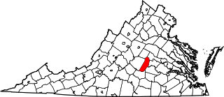
This is a list of the National Register of Historic Places listings in Cumberland County, Virginia.

<span class="mw-page-title-main">National Register of Historic Places listings in Greenbrier County, West Virginia</span>

This is a list of the National Register of Historic Places listings in Greenbrier County, West Virginia.

<span class="mw-page-title-main">National Register of Historic Places listings in Fauquier County, Virginia</span>

This is a list of the National Register of Historic Places listings in Fauquier County, Virginia.

<span class="mw-page-title-main">National Register of Historic Places listings in Halifax County, Virginia</span>

This is a list of the National Register of Historic Places listings in Halifax County, Virginia.

<span class="mw-page-title-main">National Register of Historic Places listings in Louisa County, Virginia</span>

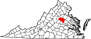
This is a list of the National Register of Historic Places listings in Louisa County, Virginia.

<span class="mw-page-title-main">National Register of Historic Places listings in Lunenburg County, Virginia</span>

This is a list of the National Register of Historic Places listings in Lunenburg County, Virginia.

<span class="mw-page-title-main">National Register of Historic Places listings in New Kent County, Virginia</span>

This is a list of the National Register of Historic Places listings in New Kent County, Virginia.

<span class="mw-page-title-main">National Register of Historic Places listings in Page County, Virginia</span>

This is a list of the National Register of Historic Places listings in Page County, Virginia.

<span class="mw-page-title-main">National Register of Historic Places listings in Petersburg, Virginia</span>

This is a list of the National Register of Historic Places listings in Petersburg, Virginia.

<span class="mw-page-title-main">National Register of Historic Places listings in Westmoreland County, Virginia</span>

This is a list of the National Register of Historic Places listings in Westmoreland County, Virginia.

<span class="mw-page-title-main">National Register of Historic Places listings in Patrick County, Virginia</span>

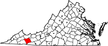
This is a list of the National Register of Historic Places listings in Patrick County, Virginia.

<span class="mw-page-title-main">National Register of Historic Places listings in Prince Edward County, Virginia</span>

This is a list of the National Register of Historic Places listings in Prince Edward County, Virginia.

<span class="mw-page-title-main">National Register of Historic Places listings in Southampton County, Virginia</span>

This is a list of the National Register of Historic Places listings in Southampton County, Virginia.

<span class="mw-page-title-main">National Register of Historic Places listings in Lewis County, West Virginia</span>

This is a list of the National Register of Historic Places listings in Lewis County, West Virginia.

<span class="mw-page-title-main">National Register of Historic Places listings in Floyd County, Virginia</span>

This is a list of the National Register of Historic Places listings in Floyd County, Virginia.

<span class="mw-page-title-main">National Register of Historic Places listings in Grayson County, Virginia</span>

This is a list of the National Register of Historic Places listings in Grayson County, Virginia.

References

  1. The latitude and longitude information provided in this table was derived originally from the National Register Information System, which has been found to be fairly accurate for about 99% of listings. Some locations in this table may have been corrected to current GPS standards.
  2. National Park Service, United States Department of the Interior, "National Register of Historic Places: Weekly List Actions", retrieved August 18, 2023.
  3. Numbers represent an alphabetical ordering by significant words. Various colorings, defined here, differentiate National Historic Landmarks and historic districts from other NRHP buildings, structures, sites or objects.
  4. "National Register Information System". National Register of Historic Places . National Park Service. April 24, 2008.
  5. The eight-digit number below each date is the number assigned to each location in the National Register Information System database, which can be viewed by clicking the number.
  6. Loth, Calder, ed. The Virginia Landmarks Register. 4th ed. Charlottesville: UP of Virginia, 1999, 491.
  7. "National Register of Historic Places Nomination Form: Saltville Battlefields Historic District" (PDF). Virginia Department of Historic Resources. Archived from the original (PDF) on January 15, 2010. Retrieved April 10, 2010.