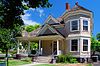
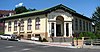
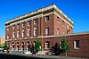
[5] Name on the Register Image Date listed [6] Location City or town Description 1 Adams Odd Fellows Hall Adams Odd Fellows Hall August 5, 1994 (# 94000810 190 Main St. 45°46′03″N 118°33′48″W / 45.76746667°N 118.5633278°W / 45.76746667; -118.5633278 (Adams Odd Fellows Hall ) Adams 2 Arlington Hotel Arlington Hotel August 28, 1997 (# 97000897 131 W. Main St. 45°44′33″N 119°11′43″W / 45.7425°N 119.195278°W / 45.7425; -119.195278 (Arlington Hotel ) Echo 3 Bank of Echo Building Bank of Echo Building April 15, 1982 (# 82003747 230 W. Main St. 45°44′33″N 119°11′39″W / 45.7425°N 119.194167°W / 45.7425; -119.194167 (Bank of Echo Building ) Echo 4 Bowman Hotel Bowman Hotel November 6, 1980 (# 80003381 17 SW Frazer Ave. 45°40′12″N 118°47′11″W / 45.669936°N 118.786398°W / 45.669936; -118.786398 (Bowman Hotel ) Pendleton 5 Central School Central School October 20, 2010 (# 10000849 306 SW 2nd Ave. 45°55′59″N 118°23′26″W / 45.933056°N 118.390556°W / 45.933056; -118.390556 (Central School ) Milton-Freewater 6 William J. and Lodema Clarke House William J. and Lodema Clarke House June 13, 1997 (# 97000576 203 NW Despain Ave. 45°40′30″N 118°47′22″W / 45.674868°N 118.789485°W / 45.674868; -118.789485 (William J. and Lodema Clarke House ) Pendleton 7 Columbia College Columbia College January 21, 2004 (# 03001481 722 S. Main St. 45°55′43″N 118°23′07″W / 45.928717°N 118.385292°W / 45.928717; -118.385292 (Columbia College ) Milton-Freewater 8 Joseph Cunha Farmstead Joseph Cunha Farmstead August 28, 1997 (# 97000898 33263 Oregon Trail Rd. 45°44′29″N 119°12′05″W / 45.741389°N 119.201389°W / 45.741389; -119.201389 (Joseph Cunha Farmstead ) Echo 9 Echo City Hall Echo City Hall August 28, 1997 (# 97000899 20 S. Bonanza St. 45°44′31″N 119°11′39″W / 45.741944°N 119.194167°W / 45.741944; -119.194167 (Echo City Hall ) Echo 10 Echo Methodist Church Echo Methodist Church August 28, 1997 (# 97000900 1 N. Bonanza St. 45°44′34″N 119°11′41″W / 45.742820°N 119.194839°W / 45.742820; -119.194839 (Echo Methodist Church ) Echo Originally built in 1886 a simple New England vernacular style, this church was expanded and transformed into the Gothic Revival style in 1910. It is the best example of Gothic Revival construction in the Echo area. [7] 11 James Edwards Building James Edwards Building August 28, 1997 (# 97000901 320 W. Main St. 45°44′32″N 119°11′34″W / 45.742222°N 119.192778°W / 45.742222; -119.192778 (James Edwards Building ) Echo 12 Ellis–Hampton House Ellis–Hampton House October 23, 1986 (# 86002909 711 SE Byers Ave. 45°40′31″N 118°46′48″W / 45.675324°N 118.779983°W / 45.675324; -118.779983 (Ellis–Hampton House ) Pendleton 13 Empire Block Empire Block June 1, 1982 (# 82003748 21–37 SW Emigrant Ave. 45°40′14″N 118°47′13″W / 45.670563°N 118.787007°W / 45.670563; -118.787007 (Empire Block ) Pendleton 14 Williams Frazier Farmstead Williams Frazier Farmstead June 5, 1986 (# 86001234 1403 Chestnut St. 45°55′24″N 118°22′36″W / 45.923333°N 118.376667°W / 45.923333; -118.376667 (Williams Frazier Farmstead ) Milton-Freewater 15 Greasewood Finnish Apostolic Lutheran Church Greasewood Finnish Apostolic Lutheran Church July 14, 1988 (# 88001041 Finn Rd. at Finland Cemetery Rd. 45°46′32″N 118°39′47″W / 45.775556°N 118.663056°W / 45.775556; -118.663056 (Greasewood Finnish Apostolic Lutheran Church ) Adams 16 Hamley and Company Leather Goods Store Hamley and Company Leather Goods Store June 9, 1982 (# 82003749 30 SE Court Ave. 45°40′22″N 118°47′12″W / 45.672683°N 118.786613°W / 45.672683; -118.786613 (Hamley and Company Leather Goods Store ) Pendleton 17 Hendricks Building (K.O.T.M.) Hendricks Building (K.O.T.M.) June 1, 1982 (# 82003750 369 S. Main St. 45°40′14″N 118°47′12″W / 45.670652°N 118.786627°W / 45.670652; -118.786627 (Hendricks Building (K.O.T.M.) ) Pendleton 18 Sarah E. Ireland House Sarah E. Ireland House January 21, 1994 (# 93001500 311 S. Main St. 45°55′56″N 118°23′10″W / 45.932222°N 118.386111°W / 45.932222; -118.386111 (Sarah E. Ireland House ) Milton-Freewater 19 Johnson–Ellis House Johnson–Ellis House March 14, 1986 (# 86000347 326 SE 2nd St. 45°40′19″N 118°47′04″W / 45.671923°N 118.784454°W / 45.671923; -118.784454 (Johnson–Ellis House ) Pendleton 20 J. H. Koontz Building J. H. Koontz Building August 28, 1997 (# 97000902 111 W. Main St. 45°44′33″N 119°11′44″W / 45.7425°N 119.195556°W / 45.7425; -119.195556 (J. H. Koontz Building ) Echo 21 James H. and Cynthia Koontz House James H. and Cynthia Koontz House August 28, 1997 (# 97000903 210 N. Dupont St. 45°44′41″N 119°11′44″W / 45.744722°N 119.195556°W / 45.744722; -119.195556 (James H. and Cynthia Koontz House ) Echo 22 LaDow Block LaDow Block October 22, 1992 (# 92001381 201–239 SE Court Ave. 45°40′25″N 118°47′07″W / 45.673566°N 118.785274°W / 45.673566; -118.785274 (LaDow Block ) Pendleton 23 Masonic Temple Masonic Temple June 1, 1982 (# 82003751 18 SW Emigrant Ave. 45°40′13″N 118°47′11″W / 45.670397°N 118.786454°W / 45.670397; -118.786454 (Masonic Temple ) Pendleton 24 Matlock–Brownfield Building Matlock–Brownfield Building June 1, 1982 (# 82003752 413–425 S. Main St. 45°40′13″N 118°47′11″W / 45.670206°N 118.786339°W / 45.670206; -118.786339 (Matlock–Brownfield Building ) Pendleton 25 Meacham Hotel Meacham Hotel August 6, 2002 (# 01000830 Main St. 45°30′28″N 118°25′10″W / 45.507778°N 118.419444°W / 45.507778; -118.419444 (Meacham Hotel ) Meacham 26 Milarkey Building Milarkey Building September 23, 1982 (# 82003753 203 S. Main St. 45°40′21″N 118°47′16″W / 45.672459°N 118.787762°W / 45.672459; -118.787762 (Milarkey Building ) Pendleton 27 Reese and Redman General Merchandise Store Reese and Redman General Merchandise Store August 8, 1994 (# 94000811 130 S. Main St. 45°45′59″N 118°33′44″W / 45.766389°N 118.562222°W / 45.766389; -118.562222 (Reese and Redman General Merchandise Store ) Adams 28 Gonzalez M. and Maude R. Rice House Gonzalez M. and Maude R. Rice House February 11, 2021 (# 100006126 503 N. Main St. 45°40′37″N 118°47′23″W / 45.676898°N 118.789635°W / 45.676898; -118.789635 (Gonzalez M. and Maude R. Rice House ) Pendleton 29 St. Peter's Roman Catholic Church St. Peter's Roman Catholic Church August 28, 1997 (# 97000905 Junction of Marble St. and Leezer Ave. 45°44′23″N 119°12′05″W / 45.7398°N 119.2014°W / 45.7398; -119.2014 (St. Peter's Roman Catholic Church ) Echo 30 Isham Saling House Isham Saling House January 1, 1976 (# 76001590 314 N. Water St. 45°49′01″N 118°25′26″W / 45.8169°N 118.4239°W / 45.8169; -118.4239 (Isham Saling House ) Weston 31 Edgar Sommerville House Edgar Sommerville House October 14, 1980 (# 80003382 104 SE 5th St. 45°40′29″N 118°46′58″W / 45.6747°N 118.7829°W / 45.6747; -118.7829 (Edgar Sommerville House ) Pendleton 32 South Main Street Commercial Historic District South Main Street Commercial Historic District October 10, 1986 (# 86003260 Roughly bounded by Dorion Ave., SE 1st St., Union Pacific Railroad, and SW 2nd St. 45°40′14″N 118°47′10″W / 45.6706°N 118.7862°W / 45.6706; -118.7862 (South Main Street Commercial Historic District ) Pendleton 33 Still–Perkins House Still–Perkins House September 9, 1993 (# 93000925 112 SE 6th Ave. 45°55′49″N 118°22′59″W / 45.9303°N 118.3831°W / 45.9303; -118.3831 (Still–Perkins House ) Milton-Freewater 34 Umatilla County Library Umatilla County Library August 15, 1997 (# 97000848 214 N. Main St. 45°40′28″N 118°47′19″W / 45.6745°N 118.7886°W / 45.6745; -118.7886 (Umatilla County Library ) Pendleton 35 Umatilla Masonic Lodge Hall Umatilla Masonic Lodge Hall August 28, 1997 (# 97000906 20 S. Dupont St. 45°44′30″N 119°11′47″W / 45.7417°N 119.1965°W / 45.7417; -119.1965 (Umatilla Masonic Lodge Hall ) Echo 36 Umatilla Site (35UM1) Umatilla Site (35UM1) January 30, 1981 (# 81000522 Address restricted [8] Umatilla The prehistoric component of this archeological site dates to 470 BCE and earlier, and may represent the largest such site in Oregon. Remains found include pit houses , stone and bone art objects, burials, and extensive animal remains, and are associated with the origins of seasonal sedentism around fishing opportunities. The site may also yield useful evidence of the historical period of the town of Umatilla. [9] 37 U.S. Post Office and Courthouse U.S. Post Office and Courthouse March 4, 1985 (# 85000544 104 SW Dorion Ave. 45°40′16″N 118°47′17″W / 45.6710°N 118.7881°W / 45.6710; -118.7881 (U.S. Post Office and Courthouse ) Pendleton 38 Joseph Vey House Joseph Vey House February 27, 1986 (# 86000299 1304 SE Court Pl. 45°40′25″N 118°46′20″W / 45.6735°N 118.7722°W / 45.6735; -118.7722 (Joseph Vey House ) Pendleton 39 Walla Walla Valley Traction Company Passenger Station and Powerhouse Walla Walla Valley Traction Company Passenger Station and Powerhouse September 9, 1993 (# 93000926 403 Robbins St. 45°56′26″N 118°23′46″W / 45.9405°N 118.3962°W / 45.9405; -118.3962 (Walla Walla Valley Traction Company Passenger Station and Powerhouse ) Milton-Freewater 40 M. L. Watts House M. L. Watts House March 9, 1988 (# 88000090 4th at Jefferson St. 45°48′47″N 118°29′16″W / 45.8131°N 118.4878°W / 45.8131; -118.4878 (M. L. Watts House ) Athena 41 Weston Commercial Historic District Weston Commercial Historic District October 5, 1982 (# 82001515 E. Main St. between Water and Broad St. 45°48′49″N 118°25′27″W / 45.8136°N 118.4241°W / 45.8136; -118.4241 (Weston Commercial Historic District ) Weston 42 Weston School Weston School December 30, 2011 (# 11000976 205 E. Wallace St. 45°48′44″N 118°25′24″W / 45.8121°N 118.4232°W / 45.8121; -118.4232 (Weston School ) Weston 43 Winn Barn Winn Barn December 30, 2011 (# 11000977 79560 Winn Rd. 45°50′25″N 118°24′19″W / 45.8404°N 118.4053°W / 45.8404; -118.4053 (Winn Barn ) Weston vicinity