National Register of Historic Places listings in Wasco County, Oregon
Last updated
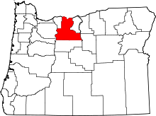
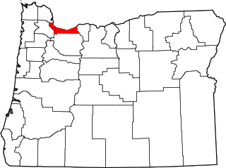
Location of Wasco County in Oregon
This list presents the full set of buildings, structures, objects, sites, or districts designated on the National Register of Historic Places in Wasco County, Oregon, and offers brief descriptive information about each of them. The National Register recognizes places of national, state, or local historic significance across the United States.[1] Out of over 90,000 National Register sites nationwide,[2]Oregon is home to over 2,000,[3] and 35 of those are found partially or wholly in Wasco County.
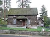
This well-preserved ensemble of 1890s Swedish Americanvernacular architecture was originally located on Pleasant Ridge, south of The Dalles. The buildings were relocated in 1972 to restore and protect them, and have been managed as a house museum since that time.[7]
This hotel was built in 1908 to serve travelers connecting between the railroad and stagecoaches. Its advanced amenities and the regular presence of salesmen made it a center of the Dufur community. Its fortunes declined with the Great Depression and the failure of the railroad, but it has remained in continuous use to the present.[8]
Built by the Columbia Southern Railway in 1900–1902 at the southern terminus of its line, this hotel is the most imposing structure in Shaniko. It was the hub of the community during the heyday of the local wool industry in the early 20th century. In addition to lodging, it served as saloon, bank, stage stop, dance hall, and general gathering place.[14]
One of only two remaining courthouses from prior to Oregon statehood, this building served Wasco County from 1859 until 1882, and then as The Dalles city hall until 1907. From its original downtown location, it has been moved several times before its current location.[15]
Yielding remains beginning soon after the end of the last glacial period, this archeological site (along with other nearby sites) provides a nearly continuous record of human occupation from at least 9000BCE to 1820CE. It also provides some of the earliest available evidence of fishing in human economy.[17]
The U.S. Army built this Gothic Revival-style house ca. 1857 to serve the medical officer of Fort Dalles. The Army occupied Fort Dalles from 1850 to 1867,[lower-alpha 4] using it as a base of operations for the northwest Indian Wars. The Surgeon's Quarters, which became a museum in 1905, is one of only two surviving structures from Fort Dalles.[19][20]
Originally built ca. 1865, this home was acquired by the French family in 1892 and renovated in the Italianate styleca. 1900. Edward French, with his uncle Daniel and other family members, were prominent bankers and businessmen from early The Dalles until the 1920s.[21]
Built ca. 1858, this house was later occupied by two figures important in The Dalles. James Fulton (in residence 1864–1881), an American emigrant, became a rancher, militia leader, and state legislator. The Rev. O.D. Taylor (in residence 1891–1897) led a long-running but failed real estate scheme that was widely regarded as fraudulent.[22]
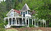
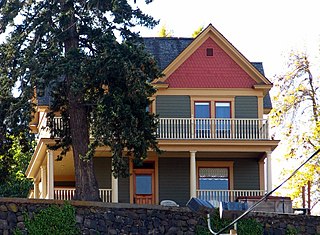
This is one of the most notable and historically well-preserved Queen Anne-style houses in The Dalles. Hugh Glenn, a prominent architect and businessman in The Dalles, designed and built the house around 1882 and lived there until his death in 1927.[23]
This 1927 Tudor Revival house was home to two prominent figures in commerce and industry in The Dalles. John G. Heimrich (in residence 1927–1931) was a leader in the development of short line railroads in Oregon. Edward Seufert (in residence 1933–1966) managed his family's locally important salmoncannery.[24]
Orlando Humason, the "Father of Wasco County", lived in this modest house from its construction in 1860 until his death in 1875. In the territorial and state legislatures, he introduced legislation establishing Wasco and Multnomah counties, and the City of The Dalles. He also championed construction of the Cascade Locks.[25]
The only remaining 19th century fishinghomestead in Oregon, this complex was built by Henry Gulick on the Columbia riverbank in the 1890s. He included a church for his wife, Harriet, a member of the Wasco people. The church was the smallest of five Indian Shaker Church congregations in the state.[26]
Joseph Kelly, a successful farmer during the establishment of wheat as a cash crop in Wasco County, built and retired to this house in 1908. He and his wife Margaret became prominent local philanthropic figures. The house is also notable for its unusual vernacular rendering of the Queen Anne style.[27]
Jefferson N. Mosier (1860–1928) first platted the town of Mosier in 1902 on what had been his father's donation land claim and promoted it for decades after. He built this prominent house in 1904, where he resided until his death. It is the only Queen Anne building in Mosier, and features many signature characteristics of the type.[31]
John Alexander Reuter (1876–1954) practiced medicine in The Dalles for 44 years, joining a partnership that established the city's first hospital (1901) and nursing school. He bought this house in 1909 and transformed it into the city's finest example of the Craftsman style.[33]
The Dalles' original Catholicparish, established in 1848, outgrew its second church by 1890. This building was constructed in 1898 based on Otto Kleemann's adaptation of plans imported from Germany. Upon its completion, it was considered the finest Catholic church in Oregon. The 1898 building became a museum in the 1960s.[36]
Edward Sharp (1865–1954) was the county surveyor and roadmaster whose work underlies much of the development in Wasco County. He built this trio of houses (1895–1905) for himself, his family, and their employees in the Queen Anne and Craftsman styles.[37]
This Beaux-Arts style Carnegie library was built in 1910 with a $10,000 grant. It was The Dalles' first public library and provided the seed for a small cluster of civic buildings, including the county courthouse and civic auditorium. In 1966, the library moved to a new facility and the Carnegie building became an arts center.[38]
Strategically located at the eastern end of the Columbia River Gorge, The Dalles became the hub of the interior Northwest in the 19th and early 20th centuries. The buildings of the historic district, built between 1860 and 1938,[lower-alpha 6] reflect the city's status and evolution as the commercial, governmental, and cultural center of Eastern Oregon.[40]
John Thompson, an emigrant and successful blacksmith, built his house in 1889 in a simple vernacular style. It underwent a major expansion in 1897 to become a prominent, Queen Anne residence. It represents the evolution of architecture in frontier towns, and is one of The Dalles' outstanding examples of the Queen Anne style.[41]
Victor Trevitt platted this first expansion of the original 1855 "Dalles City" townsite in 1860. The addition saw the first flour mill and electrical and water systems in The Dalles, and direct connection to important highway and rail networks. Surviving buildings in the district, primarily residential, reflect a spectrum of architectural styles from 1864 to 1937.[42]
Built in 1916 from standardized federal plans in the Greek Revival style, this was the first federal building in The Dalles and one of a set of nine built in Oregon in the 1910s. It remained in operation as a post office longer than seven of the other eight in that group.[43]
↑ The Barlow Road is a linear district that runs north of and roughly parallel to the line of the White and Salmon rivers from southwest of Wamic to Rhododendron. See also Hood River and Clackamas counties.
↑ The Columbia River Highway Historic District is a linear district with the Chenoweth Creek Bridge, The Dalles, at its east end, and the Sandy River Bridge, Troutdale, at the west end. See also Hood River and Multnomah counties.
1 2 Federal and state laws and practices restrict general public access to information regarding the specific location of this resource. In some cases, this is to protect archeological sites from vandalism, while in other cases it is restricted at the request of the owner.
1 2 The Army established Camp Drum in 1850. The post became Fort Drum and then Fort Dalles in 1853.[18]
↑ Most of Harriman's tracks and stations in the Deschutes canyon were abandoned in 1936. The other two buildings of the Maupin station, the depot and the maintenance crew bunk, were demolished by 1968.
↑ The district's 1997 National Register nomination file listed the Port of The Dalles Grain Elevator, built in 1942, as a contributing resource in the district. However the grain elevator was subsequently removed, leaving 1938 as the most recent date of construction of a contributing building.
Related Research Articles
The following list presents the full set of National Register of Historic Places listings in Multnomah County, Oregon. However, please see separate articles for listings in each of Portland's six quadrants.
The Dalles Carnegie Library is a historic former library building located in The Dalles, Oregon, United States. It is one of the thousands of libraries whose construction was funded by Andrew Carnegie. The construction grant of $10,000 was approved in March 1907, and it was dedicated in September 1910.
Trevitt's Addition Historic District is a neighborhood, primarily residential in character, located in The Dalles, Oregon, United States. Victor Trevitt platted the first expansion of the original 1855 "Dalles City" townsite in 1860, and continued to extend his addition in response to economic developments. The district saw the first flour mill and electrical and water systems in The Dalles, one of the area's earliest Catholic churches, and direct connection to transportation networks including the Columbia River Highway and the railroad. Surviving buildings in the district reflect a continuous spectrum of architectural styles from 1864 to 1937.
The Bennett–Williams House is a historic house, located in The Dalles, Oregon, United States. It is listed on the National Register of Historic Places, and is also listed as a contributing resource in the National Register-listed Trevitt's Addition Historic District.
The Original Wasco County Courthouse is a historic former courthouse, located in The Dalles, Oregon, United States. It is listed on the National Register of Historic Places under the name First Wasco County Courthouse, and is also listed as a contributing resource in the National Register-listed Trevitt's Addition Historic District.
The Heimrich–Seufert House is a historic house in The Dalles, Oregon, United States.
The Lewis Anderson House, Barn and Granary is a historic ensemble of buildings, currently located in The Dalles, Oregon, United States. This well-preserved set of 1890s Swedish American vernacular architecture was originally located on a farm on Pleasant Ridge, south of The Dalles. Lewis Anderson was a Swedish immigrant who, after establishing himself on Pleasant Ridge, worked semi-successfully to encourage further Swedish settlement in the area of The Dalles. The sidehill barn, with grade entrances on two levels, was the first erected of the ensemble, in 1890. The house was built by Anderson and fellow Swedish immigrant Ab Pearson in 1895. Anderson purchased and relocated the granary from a neighboring farm in 1898, in the process repurposing it from its previous function as a house.
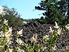
The Rock Fort Campsite is a natural fortification on the south shore of the Columbia River in The Dalles, Oregon, United States. The Lewis and Clark Expedition camped at this defensible spot for three nights in late October 1805, just after it passed Celilo Falls on its descent to the Pacific Ocean, and again for one night on their return journey. It was here that the expedition first made significant contact and commerce with the Chinookan-speaking peoples of the lower Columbia.
The Edward French House is a historic house located in The Dalles, Oregon, United States. Originally dating from circa 1865, it was acquired by the French family in 1892 and renovated by them in the Italianate style in circa 1900. Edward French, along with his uncle Daniel and other members of the French family, were prominent bankers and businessmen from early The Dalles until the 1920s.
The Indian Shaker Church and Gulick Homestead are an ensemble of historic buildings in The Dalles, Oregon, United States. Built by Henry Gulick directly on the Columbia riverbank in the 1890s, it is the only remaining 19th century fishing homestead in Oregon. Gulick, an employee of the locally-important Seufert salmon canning concern, included a church building in the complex in ca. 1896 for his wife, Harriet, a member of the Wasco people. The church was the smallest of five Indian Shaker Church congregations in the state.
The Orlando Humason House is a historic house located in The Dalles, Oregon, United States. Humason (1828–1875), the "Father of Wasco County", lived in this modest Gothic Revival house from its construction in 1860 until his death. Originally from Ohio, he worked in law, prospecting, agriculture, and journalism, prior to settling in The Dalles as a prosperous merchant and river transport businessman. Representing first Oregon City then The Dalles in the territorial and state legislatures, he introduced legislation establishing Wasco County, Multnomah County, and the City of The Dalles. He also championed a bill to build a canal around the Cascades Rapids to allow Lower Columbia shipping to reach The Dalles, which did not come to fruition in his lifetime. Humason's other public positions included mayor of The Dalles and Wasco County judge. The house is architecturally notable as one of very few Gothic Revival houses in The Dalles.
The former United States Post Office in The Dalles, Oregon, United States, is a historic building constructed in 1916. Executed from standardized federal plans in the Greek Revival style, it was the first federal building in The Dalles and one of a set of nine built in Oregon in the 1910s. It remained in operation as a post office longer than seven of the other eight in that group. The building was added to the National Register of Historic Places in 1985.
The Dalles Commercial Historic District comprises a primarily commercial and civic portion of downtown The Dalles, Oregon, United States. Strategically located at the eastern end of the Columbia River Gorge and near Celilo Falls, The Dalles became the preeminent transportation and trading hub of the interior Northwest in the 19th and early 20th centuries. The 46 historic buildings and other features of the district, built between 1860 and 1938, reflect the city's status and evolution as the gateway to the Columbia Plateau and the commercial, governmental, and cultural center of Eastern Oregon.
The Joseph D. and Margaret Kelly House is a historic residence in The Dalles, Oregon, United States. Joseph Kelly, a highly successful farmer during the establishment of wheat as a major cash crop in Wasco County, retired young to this 1908 blufftop house and continued his career as a landlord and businessman. He and his wife Margaret, a teacher and member of another important wheat family, became a prominent philanthropic figures in The Dalles. The house is architecturally notable for its vernacular rendering of the Queen Anne style, reflecting the Kellys' rural background in contrast to the high Victorian approach used elsewhere in The Dalles.
↑ Oregon Parks and Recreation Department, Oregon Historic Sites Database, retrieved August 6, 2015. Note that a simple count of National Register records in this database returns a slightly higher total than actual listings, due to duplicate records. A close reading of detailed query results is necessary to arrive at the precise count.
↑ Numbers represent an alphabetical ordering by significant words. Various colorings, defined here, differentiate National Historic Landmarks and historic districts from other NRHP buildings, structures, sites or objects.
↑ The eight-digit number below each date is the number assigned to each location in the National Register Information System database, which can be viewed by clicking the number.
This page is based on this Wikipedia article Text is available under the CC BY-SA 4.0 license; additional terms may apply. Images, videos and audio are available under their respective licenses.