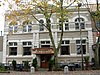
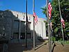
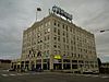
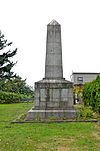
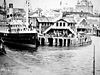
[3] Name on the Register [4] Image Date listed [5] Location City or town Description 1 Aftermath Clubhouse Aftermath Clubhouse December 14, 1978 (# 78002785 1300 Broadway 48°45′28″N 122°29′24″W / 48.757778°N 122.49°W / 48.757778; -122.49 (Aftermath Clubhouse ) Bellingham Some guess Aftermath Clubhouse to be the first women's clubhouse built in Washington. [6] 2 Austin Pass Warming Hut Austin Pass Warming Hut December 21, 1990 (# 90001866 Southeast of Bagley Lakes, Mt. Baker-Snoqualmie NF 48°51′18″N 121°40′59″W / 48.855°N 121.683056°W / 48.855; -121.683056 (Austin Pass Warming Hut ) Glacier 3 Dr. William H. and Frances C. Axtell House Dr. William H. and Frances C. Axtell House March 7, 2012 (# 12000087 413 E. Maple St. 48°44′44″N 122°28′41″W / 48.745493°N 122.478143°W / 48.745493; -122.478143 (Dr. William H. and Frances C. Axtell House ) Bellingham 4 B. P. O. E. Building B. P. O. E. Building March 26, 1992 (# 92000282 1412-1414 Cornwall Ave. 48°45′05″N 122°28′31″W / 48.751389°N 122.475278°W / 48.751389; -122.475278 (B. P. O. E. Building ) Bellingham Also known as the Elk's Club. 5 George H. Bacon House George H. Bacon House November 21, 1974 (# 74001989 2001 Eldridge Ave. 48°45′33″N 122°29′43″W / 48.759167°N 122.495278°W / 48.759167; -122.495278 (George H. Bacon House ) Bellingham Built by Henry Bacon, first cousin of George. 6 Barlow Building Barlow Building December 15, 2004 (# 04001371 211 W. Holly St. 48°45′09″N 122°28′50″W / 48.7525°N 122.480556°W / 48.7525; -122.480556 (Barlow Building ) Bellingham The Barlow Building currently houses Goat Mountain Pizza. 7 Beaver Pass Shelter Beaver Pass Shelter February 10, 1989 (# 88003448 Beaver Pass, 14 mi (23 km). west of Ross Lake 48°52′20″N 121°14′56″W / 48.872222°N 121.248889°W / 48.872222; -121.248889 (Beaver Pass Shelter ) Diablo 8 Bellingham City Hall Bellingham City Hall December 30, 2011 (# 11000987 210 Lottie St. 48°45′20″N 122°28′44″W / 48.755517°N 122.478839°W / 48.755517; -122.478839 (Bellingham City Hall ) Bellingham 9 Bellingham Herald Building Bellingham Herald Building December 31, 2013 (# 13001032 1155 N. State St. 48°44′51″N 122°28′45″W / 48.747440°N 122.479091°W / 48.747440; -122.479091 (Bellingham Herald Building ) Bellingham 10 Bellingham National Bank Building Bellingham National Bank Building October 13, 1983 (# 83004275 101-111 E. Holly St. 48°45′00″N 122°28′38″W / 48.75°N 122.477222°W / 48.75; -122.477222 (Bellingham National Bank Building ) Bellingham 11 Berthusen Barn and Privy Berthusen Barn and Privy April 22, 2003 (# 03000306 8837 Bethusen Rd. 48°57′43″N 122°30′25″W / 48.961944°N 122.506944°W / 48.961944; -122.506944 (Berthusen Barn and Privy ) Lynden 12 Alfred L. Black House Alfred L. Black House December 4, 1980 (# 80004012 158 S. Forest St. 48°44′07″N 122°29′38″W / 48.735278°N 122.493889°W / 48.735278; -122.493889 (Alfred L. Black House ) Bellingham Also known as Wahl House. 13 Boundary Marker No. 1 Boundary Marker No. 1 May 30, 1975 (# 75001881 Marine Dr. at U.S./Canada border 49°00′08″N 123°05′17″W / 49.002222°N 123.088056°W / 49.002222; -123.088056 (Boundary Marker No. 1 ) Point Roberts 14 Broadway Park Historic District Broadway Park Historic District January 4, 2012 (# 11001014 Roughly bounded by Illinois, W. North, Summer & Ellis Sts. 48°45′55″N 122°28′37″W / 48.765247°N 122.476847°W / 48.765247; -122.476847 (Broadway Park Historic District ) Bellingham 15 Cissna Cottages Historic District Cissna Cottages Historic District January 11, 2010 (# 09001219 Area roughly bounded by H., Halleck, G., and Girard Sts. [7] 48°45′35″N 122°29′02″W / 48.759761°N 122.483789°W / 48.759761; -122.483789 (Cissna Cottages Historic District ) Bellingham 16 Copper Mountain Fire Lookout Copper Mountain Fire Lookout February 10, 1989 (# 88003446 On Copper Mountain, 10 mi (16 km). east of Hannegan Campground 48°54′33″N 121°27′41″W / 48.909167°N 121.461389°W / 48.909167; -121.461389 (Copper Mountain Fire Lookout ) Newhalem 17 Daylight Building Daylight Building December 15, 2004 (# 04001370 1201-1213 N. State St. 48°44′59″N 122°28′43″W / 48.749722°N 122.478611°W / 48.749722; -122.478611 (Daylight Building ) Bellingham 18 Deer Lick Cabin Deer Lick Cabin February 10, 1989 (# 88003452 East of Ross Lake on Lightning Creek Trail, south of Three Fools Trail 48°54′00″N 120°58′46″W / 48.9°N 120.979444°W / 48.9; -120.979444 (Deer Lick Cabin ) Hozomeen 19 Desolation Peak Lookout Desolation Peak Lookout February 10, 1989 (# 88003451 On Desolation Peak east of Ross Lake, 6 mi (9.7 km). south of Canada–US border 48°54′42″N 121°00′54″W / 48.911667°N 121.015°W / 48.911667; -121.015 (Desolation Peak Lookout ) Hozomeen 20 Devil's Corner Cliff Walk Devil's Corner Cliff Walk June 7, 1974 (# 74000909 North of Newhalem in Ross Lake National Recreation Area 48°41′28″N 121°13′23″W / 48.691111°N 121.223056°W / 48.691111; -121.223056 (Devil's Corner Cliff Walk ) Newhalem 21 Diablo Hydroelectric Power Plant Diablo Hydroelectric Power Plant June 30, 1989 (# 89000498 Off WA 20 at W end of Diablo Lake 48°42′52″N 121°08′04″W / 48.714444°N 121.134444°W / 48.714444; -121.134444 (Diablo Hydroelectric Power Plant ) Newhalem Consists of 520 acres (2.1 km2 ), 1 building, and 8 structures. 22 J. J. Donovan House J. J. Donovan House January 27, 1983 (# 83003356 1201 Garden St. 48°44′47″N 122°28′31″W / 48.746389°N 122.475278°W / 48.746389; -122.475278 (J. J. Donovan House ) Bellingham Was used as a women's dormitory by Western Washington University for roughly 25 years. 23 Downtown Bellingham Historic District Downtown Bellingham Historic District December 29, 2014 (# 14001110 Roughly bounded by E. Maple, N. Forest, York, Prospect, Bay & W. Chestnut Sts., Central & Cornwall Aves. 48°45′43″N 122°29′48″W / 48.761944°N 122.496667°W / 48.761944; -122.496667 (Downtown Bellingham Historic District ) Bellingham 24 Eldridge Avenue Historic District Eldridge Avenue Historic District July 27, 1979 (# 79002566 Eldridge Ave. and environs 48°45′43″N 122°29′48″W / 48.761944°N 122.496667°W / 48.761944; -122.496667 (Eldridge Avenue Historic District ) Bellingham Encompasses 1,500 acres (6.1 km2 ), 683 buildings, and 1 structure. 25 Eldridge Homesite and Mansion Eldridge Homesite and Mansion January 27, 1983 (# 83003357 2915 Eldridge Ave. 48°45′46″N 122°30′29″W / 48.762778°N 122.508056°W / 48.762778; -122.508056 (Eldridge Homesite and Mansion ) Bellingham The home currently occupying the site, is the fourth, being built after three others burned. 26 Fairhaven Historic District Fairhaven Historic District August 19, 1977 (# 77001363 Roughly bounded by 10th and 13th Sts., Columbia and Larrabee Aves. 48°43′13″N 122°30′07″W / 48.720278°N 122.501944°W / 48.720278; -122.501944 (Fairhaven Historic District ) Bellingham Roughly bounded by 10th and 13th Sts., Columbia and Larrabee Aves., (85 acres, 16 buildings) 27 Fairhaven Library Fairhaven Library August 3, 1982 (# 82004907 1105 12th St. 48°43′17″N 122°30′05″W / 48.721389°N 122.501389°W / 48.721389; -122.501389 (Fairhaven Library ) Bellingham Carnegie Libraries of Washington TR 28 Fish and Game-Hozomeen Cabin Fish and Game-Hozomeen Cabin February 10, 1989 (# 88003454 Hozomeen Lake-Lightning Creek trailhead on E side of Ross Lake 48°59′08″N 121°04′07″W / 48.985556°N 121.068611°W / 48.985556; -121.068611 (Fish and Game-Hozomeen Cabin ) Hozomeen 29 Flatiron Building Flatiron Building January 27, 1983 (# 83003358 1311-1319 Bay St. 48°45′07″N 122°28′47″W / 48.751944°N 122.479722°W / 48.751944; -122.479722 (Flatiron Building ) Bellingham Bellingham's first "Skyscraper". It was originally built for the Bellingham Bay (B.B.) Furniture Co. 30 Gamwell House Gamwell House March 16, 1972 (# 72001282 1001 16th St. 48°43′26″N 122°29′44″W / 48.723889°N 122.495556°W / 48.723889; -122.495556 (Gamwell House ) Bellingham 31 Glacier Ranger Station Glacier Ranger Station September 17, 1980 (# 80004013 Mount Baker Hwy. 48°53′16″N 121°56′07″W / 48.887778°N 121.935278°W / 48.887778; -121.935278 (Glacier Ranger Station ) Glacier 32 Gorge Hydroelectric Power Plants Gorge Hydroelectric Power Plants June 30, 1989 (# 89000499 Off WA 20 at W end of Gorge Lake 48°40′32″N 121°14′25″W / 48.675661°N 121.240274°W / 48.675661; -121.240274 (Gorge Hydroelectric Power Plants ) Newhalem 820 acres (3.3 km2 ), 1 building, and 6 structures 33 Great Northern Passenger Station Great Northern Passenger Station May 30, 1975 (# 75001879 S end of D St. 48°45′14″N 122°29′07″W / 48.753889°N 122.485278°W / 48.753889; -122.485278 (Great Northern Passenger Station ) Bellingham Building is currently utilized by Burlington Northern-Santa Fe. 34 Hotel Laube Hotel Laube August 29, 2003 (# 01000477 1226 N. State St. 48°44′52″N 122°28′35″W / 48.747778°N 122.476389°W / 48.747778; -122.476389 (Hotel Laube ) Bellingham Currently being remodeled. 35 Hovander Homestead Hovander Homestead October 16, 1974 (# 74001990 5299 Neilson Rd. 48°49′46″N 122°35′24″W / 48.829444°N 122.59°W / 48.829444; -122.59 (Hovander Homestead ) Ferndale 36 Immanuel School of Industries-Department of Public Welfare Immanuel School of Industries-Department of Public Welfare November 7, 2003 (# 03001127 1303 Astor St. 48°53′10″N 122°39′39″W / 48.886111°N 122.660833°W / 48.886111; -122.660833 (Immanuel School of Industries-Department of Public Welfare ) Bellingham 37 International Boundary US-Canada Upload image February 10, 1989 (# 88003450 Along US-Canada border between eastern boundary of Ross Lake NRA and western boundary of North Cascades National Park 49°00′04″N 121°31′19″W / 49.001111°N 121.521944°W / 49.001111; -121.521944 (International Boundary US-Canada ) Hozomeen 38 Koma Kulshan Ranger Station Koma Kulshan Ranger Station June 10, 1991 (# 91000708 Forest Rd. 11, west of Baker Lake, Mt. Baker National Forest 48°39′42″N 121°42′49″W / 48.661667°N 121.713611°W / 48.661667; -121.713611 (Koma Kulshan Ranger Station ) Concrete 39 Larrabee House Larrabee House May 30, 1975 (# 75001880 405 Fieldston Rd. 48°42′43″N 122°30′26″W / 48.711944°N 122.507222°W / 48.711944; -122.507222 (Larrabee House ) Bellingham Commissioned by Charles Xavier Larrabee , he did not live to see it built. Also known as Lairmont Manor and Mt. St. Mary's Novitiate. 40 Leopold Hotel Leopold Hotel February 19, 1982 (# 82004306 1224 Cornwall Ave. 48°44′57″N 122°28′43″W / 48.749167°N 122.478611°W / 48.749167; -122.478611 (Leopold Hotel ) Bellingham The Leopold Hotel currently houses a retirement home. 41 Lynden Department Store Lynden Department Store July 20, 2011 (# 11000476 444 Front St. 48°56′35″N 122°27′10″W / 48.943056°N 122.452778°W / 48.943056; -122.452778 (Lynden Department Store ) Lynden Also known as the Waples Building / Delft Square. Heavily damaged by fire in 2008. 42 Middle Fork Nooksack River Bridge Middle Fork Nooksack River Bridge July 16, 1982 (# 82004305 Mosquito Lake Rd. 48°47′05″N 122°06′40″W / 48.784722°N 122.111111°W / 48.784722; -122.111111 (Middle Fork Nooksack River Bridge ) Acme Historic Bridges and Tunnels in Washington TR 43 Montague and McHugh Building Montague and McHugh Building April 29, 1993 (# 93000371 114 W. Magnolia St. 48°45′05″N 122°28′41″W / 48.751378°N 122.478075°W / 48.751378; -122.478075 (Montague and McHugh Building ) Bellingham Designed by John Graham Sr. 44 Morse Hardware Company Building Morse Hardware Company Building February 2, 2005 (# 04001594 1023-1025 N. State St. 48°44′52″N 122°28′52″W / 48.747778°N 122.481111°W / 48.747778; -122.481111 (Morse Hardware Company Building ) Bellingham 45 Robert I. Morse House Robert I. Morse House November 7, 1977 (# 77001364 1014 N. Garden St. 48°44′41″N 122°28′38″W / 48.744722°N 122.477222°W / 48.744722; -122.477222 (Robert I. Morse House ) Bellingham 46 Mount Baker Theatre Mount Baker Theatre December 14, 1978 (# 78002786 106 N. Commercial St. 48°45′08″N 122°28′36″W / 48.752222°N 122.476667°W / 48.752222; -122.476667 (Mount Baker Theatre ) Bellingham Designed by Robert Reamer , designer of the Old Faithful Inn. 47 MV Plover MV Plover June 4, 1997 (# 97000551 245 Marine Dr.;Blaine Harbor Berth A-11 48°59′37″N 122°45′31″W / 48.993611°N 122.758611°W / 48.993611; -122.758611 (MV Plover ) Blaine 48 Nooksack Falls Hydroelectric Power Plant Nooksack Falls Hydroelectric Power Plant December 15, 1988 (# 88002735 Rt. 542 on Nooksack River 48°54′33″N 121°49′31″W / 48.909167°N 121.825278°W / 48.909167; -121.825278 (Nooksack Falls Hydroelectric Power Plant ) Glacier 49 Oakland Block Oakland Block March 25, 1999 (# 99000403 310-318 W. Holly St. and 419 Champion St. 48°45′06″N 122°28′54″W / 48.7517°N 122.4817°W / 48.7517; -122.4817 (Oakland Block ) Bellingham The Oakland Block was recently remodeled to provide low-income housing. 50 Old Main, Western Washington State College Old Main, Western Washington State College November 7, 1977 (# 77001365 516 High St. 48°44′17″N 122°28′58″W / 48.738056°N 122.482778°W / 48.738056; -122.482778 (Old Main, Western Washington State College ) Bellingham 51 Orchard Terrace Apartments Orchard Terrace Apartments July 21, 2015 (# 15000456 901 N. Forest St. 48°44′37″N 122°28′56″W / 48.7436°N 122.4821°W / 48.7436; -122.4821 (Orchard Terrace Apartments ) Bellingham 52 Park Butte Lookout Park Butte Lookout July 14, 1987 (# 87001189 Mt. Baker Ranger District, southwest of the Easton Glacier of Mt. Baker 48°42′59″N 121°51′18″W / 48.716389°N 121.855°W / 48.716389; -121.855 (Park Butte Lookout ) Sedro-Woolley vicinity 53 Peace Arch Peace Arch December 13, 1996 (# 96001493 Peace Arch State Park, US 5 at the Canada–US border 48°59′59″N 122°45′10″W / 48.999722°N 122.752778°W / 48.999722; -122.752778 (Peace Arch ) Blaine 54 Perry Creek Shelter Perry Creek Shelter February 10, 1989 (# 88003447 On Little Beaver Trail, 5 mi (8.0 km). west of Ross Lake 48°55′16″N 121°09′21″W / 48.921111°N 121.155833°W / 48.921111; -121.155833 (Perry Creek Shelter ) Hozomeen 55 Pickett House Pickett House December 13, 1971 (# 71000881 910 Bancroft St. 48°45′23″N 122°29′04″W / 48.756389°N 122.484444°W / 48.756389; -122.484444 (Pickett House ) Bellingham The former home of George Pickett is the oldest building in Bellingham. 56 T. G. Richards and Company Store T. G. Richards and Company Store August 28, 2003 (# 03000861 1308 E St. 48°45′17″N 122°29′10″W / 48.754786°N 122.486208°W / 48.754786; -122.486208 (T. G. Richards and Company Store ) Bellingham Later became the Washington Territorial Courthouse. The oldest brick building in Washington. 57 Victor A. Roeder House Victor A. Roeder House November 7, 1977 (# 77001366 2600 Sunset Dr. 48°45′56″N 122°28′41″W / 48.765556°N 122.478056°W / 48.765556; -122.478056 (Victor A. Roeder House ) Bellingham The home currently provides space for different educational activities. 58 Lottie Roth Block Lottie Roth Block December 12, 1978 (# 78002787 1106 W. Holly St. 48°45′22″N 122°29′14″W / 48.756111°N 122.487222°W / 48.756111; -122.487222 (Lottie Roth Block ) Bellingham 59 Sanitary Meat Market Sanitary Meat Market February 2, 2005 (# 04001593 1015-1019 N. State St. 48°44′52″N 122°28′53″W / 48.747778°N 122.481389°W / 48.747778; -122.481389 (Sanitary Meat Market ) Bellingham The Sanitary Meat Market originally occupied 1015-1019 N. State St., now only 1017. 60 Sehome Hill Historic District Sehome Hill Historic District February 13, 2001 (# 01000063 Portions of Jersey, Key, Liberty, Mason, Newell, E. Myrtle, E. Laurel, and E. Maple Sts. 48°44′23″N 122°28′32″W / 48.739608°N 122.475472°W / 48.739608; -122.475472 (Sehome Hill Historic District ) Bellingham Includes portions of Jersey, Key, Liberty, Mason, Newell, E. Myrtle, E. Laurel, and E. Maple Streets, with 153 buildings. 61 Si'ke village with historic area called Tsi'lich Si'ke village with historic area called Tsi'lich June 30, 2000 (# 00000697 Address Restricted Blaine 62 Skagit River and Newhalem Creek Hydroelectric Projects Skagit River and Newhalem Creek Hydroelectric Projects April 26, 1996 (# 96000416 At Newhalem on the Skagit River and at Ross Dam 48°41′50″N 121°11′14″W / 48.697222°N 121.187222°W / 48.697222; -121.187222 (Skagit River and Newhalem Creek Hydroelectric Projects ) Newhalem 420 acres (1.7 km2 ), 21 buildings, 5 structures, and 1 object 63 Sourdough Mountain Lookout Sourdough Mountain Lookout February 10, 1989 (# 88003449 On Sourdough Mountain, 5 mi (8.0 km). northeast of Diablo 48°44′34″N 121°06′29″W / 48.742778°N 121.108056°W / 48.742778; -121.108056 (Sourdough Mountain Lookout ) Diablo 64 South Hill Historic District South Hill Historic District February 24, 2010 (# 09001296 Bounded by Knox, 11th, State, Cedar, 17th, and Highland 48°43′42″N 122°29′52″W / 48.728372°N 122.497747°W / 48.728372; -122.497747 (South Hill Historic District ) Bellingham 65 U.S. Post Office and Courthouse U.S. Post Office and Courthouse April 30, 1979 (# 79003157 104 W. Magnolia St. 48°45′05″N 122°28′35″W / 48.751389°N 122.476389°W / 48.751389; -122.476389 (U.S. Post Office and Courthouse ) Bellingham Formerly the Bellingham Federal Building, the building is now owned by the city. 66 US Post Office-Lynden Main US Post Office-Lynden Main August 7, 1991 (# 91000648 600 Front St. 48°56′34″N 122°27′13″W / 48.942778°N 122.453611°W / 48.942778; -122.453611 (US Post Office-Lynden Main ) Lynden 67 James F. Wardner House James F. Wardner House December 1, 1988 (# 88002744 1103 15th St. 48°43′21″N 122°29′49″W / 48.7225°N 122.496944°W / 48.7225; -122.496944 (James F. Wardner House ) Bellingham Also known as Wardner Castle, James Wardner only lived in the home for one year. 68 Washington Grocery Company Warehouse Washington Grocery Company Warehouse December 13, 1996 (# 96001494 1125 Railroad Ave. 48°44′54″N 122°29′33″W / 48.748333°N 122.4925°W / 48.748333; -122.4925 (Washington Grocery Company Warehouse ) Bellingham 69 Whatcom Museum of History and Art Whatcom Museum of History and Art April 3, 1970 (# 70000648 121 Prospect St. 48°45′10″N 122°28′48″W / 48.752778°N 122.48°W / 48.752778; -122.48 (Whatcom Museum of History and Art ) Bellingham Formerly the Bellingham City Hall. 70 Wild Goose Pass Tree Upload image June 7, 1991 (# 91000706 Address Restricted Glacier 71 Winchester Mountain Lookout Winchester Mountain Lookout July 14, 1987 (# 87001188 Mt. Baker Wilderness Area overlooking the N fork of Nooksack River and W fork of Silesia Creek 48°57′25″N 121°38′31″W / 48.956944°N 121.641944°W / 48.956944; -121.641944 (Winchester Mountain Lookout ) Sedro-Woolley vicinity 72 York Historic District York Historic District February 1, 2010 (# 09001297 Bounded roughly by Ellis St., Meador Ave., I-5 , and Lakeway Dr. 48°44′57″N 122°28′05″W / 48.7493°N 122.468033°W / 48.7493; -122.468033 (York Historic District ) Bellingham 73 Woodstock Farm Woodstock Farm August 10, 2021 (# 100006806 1200 Chuckanut Dr. 48°41′52″N 122°29′45″W / 48.6979°N 122.4958°W / 48.6979; -122.4958 (Woodstock Farm ) Bellingham 74 Young Women's Christian Association Young Women's Christian Association April 21, 1977 (# 77001367 1026 N. Forest St. 48°44′43″N 122°28′44″W / 48.7452688°N 122.478953°W / 48.7452688; -122.478953 (Young Women's Christian Association ) Bellingham