Related Research Articles

Japan attracted 31.19 million international tourists in 2018. Japan has 21 World Heritage Sites, including Himeji Castle, Historic Monuments of Ancient Kyoto and Nara. Popular foreigner attractions include Tokyo and Hiroshima, Mount Fuji, ski resorts such as Niseko in Hokkaido, Okinawa, riding the shinkansen and taking advantage of Japan's hotel and hotspring network.
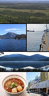
Kushiro is a city in Kushiro Subprefecture on the island of Hokkaido, Japan. It serves as the subprefecture's capital and it is the most populated city in the eastern part of the island.

Akan Mashu National Park is a national park located on the island of Hokkaidō, Japan. Along with Daisetsuzan National Park, these are the two oldest national parks in Hokkaidō. The park was established December 4, 1934.

Daisetsuzan National Park, or Taisetsuzan is located in the mountainous center of the northern Japanese island of Hokkaidō. At 2,267.64 square kilometres (875.54 sq mi), Daisetsuzan is the largest national park in Japan, and is approximately the size of Kanagawa Prefecture. Daisetsuzan, meaning "great snowy mountains", an apt description of these peaks. There are 16 peaks over 2,000 metres (6,600 ft) in Daisetsuzan National Park, both with and without trails. The park offers some of the most rugged scenery in Japan. Asahidake, located in the north of the park, is the highest peak in Hokkaidō. Daisetsuzan National Park spans two subprefectures of Hokkaidō, Kamikawa and Tokachi. Daisetsuzan National Park was established in 1934.

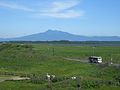
Toyotomi is a town located in Sōya Subprefecture, Hokkaido, Japan. It contains the Sarobetsu Plain, which is part of Rishiri-Rebun-Sarobetsu National Park, and is famous for its hot springs.

Rebun is a town located in Sōya Subprefecture, Hokkaido, Japan. The district and town both cover the island of the same name: Rebun Island. Rebun Island is famous for its alpine flowers.

Rebun is a district located in Sōya Subprefecture, Hokkaido, Japan. The district and town both cover the island of the same name: Rebun Island.

Rishiri is a town located on Rishiri Island in Sōya Subprefecture, Hokkaido, Japan.

Rausu is a town located in Nemuro Subprefecture, Hokkaido, Japan. As of September 30, 2016, it has an estimated population of 5,395, and an area of 397.88 km2.

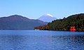
Lake Tōya is a volcanic caldera lake in Shikotsu-Toya National Park, Abuta District, Hokkaidō, Japan. It is part of "Toya Caldera and Usu Volcano Global Geopark" which joins in Global Geoparks Network. The stratovolcano of Mount Usu lies on the southern rim of the caldera. The lake is nearly circular, being 10 kilometers in diameter from east–west and 9 kilometers from north–south. The town of Tōyako comprises most of the area surrounding the lake and the town of Sōbetsu is located on the eastern side.

Rishiri Island is a high island in the Sea of Japan off the coast of Hokkaido, Japan. Administratively the island is part of Hokkaido Prefecture, and is divided between two towns, Rishiri and Rishirifuji. The island is formed by the cone-shaped extinct volcanic peak of Mount Rishiri. Along with Rebun Island and the coastal area of the Sarobetsu Plain, Rishiri forms the Rishiri-Rebun-Sarobetsu National Park. The main industries of Rishiri are tourism and fishing. The island is about 63 kilometres (39 mi) in circumference and covers 183 square kilometres (71 sq mi). The island has a population of 5,102 residents.
Rebun Island is an island in the Sea of Japan off the northwestern tip of Hokkaidō, Japan. The island sits 50 kilometres (31 mi) off the coast of Hokkaidō. Rebun stretches 29 kilometres (18 mi) from north to south and 8 kilometres (5.0 mi) from east to west. The island covers approximately 80 square kilometres (31 sq mi). Rebun Island is located 10 kilometres (6.2 mi) northwest of Rishiri Island, and the two islands are separated by the Rebun Channel.

Kiritappu Wetland is a 3,168ha. wetland area in Hamanaka-cho, Akkeshi District, Hokkaidō, Japan. It is also called Wetland of flowers (花の湿原) because numerous flowers can be seen in summer.

Tōyako is a town in Iburi Subprefecture, Hokkaido, Japan. It was formed on March 23, 2006, through the merger of the town of Abuta and the village of Tōya. As of 30 September 2016, the town has an estimated population of 9,231, and a population density of 51 persons per km². The total area is 180.54 km².

Lake Shikotsu is a caldera lake in Chitose, Hokkaidō, Japan. It is a part of the Shikotsu-Toya National Park.

Sōunkyō is a range of gorges located in Kamikawa, Hokkaidō, Japan. Situated in the Daisetsuzan National Park, the area is known for its hotels and onsen resorts as well as waterfalls and magnificent cliffs scenery. The term "Sōunkyō" means respectively the layer (層), cloud (雲) and gorge (峡) in Japanese, and the origin of the name is a word "Souunbetsu" in Ainu language, which means "the river with many waterfalls".

Lake Kuttara is a nearly circular caldera lake in Shiraoi, Hokkaidō, Japan. It is part of Shikotsu-Tōya National Park. The lake is recognized as having the best water quality in all of Japan. With a transparency of 19 metres (62 ft), the lake ranks second to Lake Mashū according to the Ministry of the Environment.

Sarobetsu-genya (サロベツ原野), derived from the Ainu sar (marsh) and pet (river), is a coastal plain and low-lying moor in northwestern Hokkaidō, Japan. With an area of approximately 20,000 ha or 200 km2 (77 sq mi), it forms part of the Rishiri-Rebun-Sarobetsu National Park, and its wetlands are a Ramsar Site.
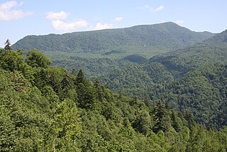
The Hokkaido montane conifer forests ecoregion covers the mountainous central regions of Hokkaido Island, the northernmost of Japan's main islands. Forests of spruce and fir thrive in the subalpine, cool climate. On the northeastern edge of the island, the conifer forests extend down to the sea under the influence of the cold Oyashio Current coming down from the north, although logging in recent years has put pressure on these stands.
References
- ↑ National Parks in Japan; retrieved 2012-12-12.
- ↑ "National Parks of Japan". www.japan-guide.com. Retrieved 2020-01-31.
- ↑ Japan Ministry of the Environment, "General overview of area figures for Natural Parks by prefecture"; retrieved 2012-3-14.
- ↑ Akan Tourism Association & Community Development Promotion Organization, Akan National Park Archived 2013-11-21 at the Wayback Machine ; retrieved 2012-12-12.
- ↑ Japan Integrated Biodiversity Information System (JIBIS), Akan National Park 90,481 ha,:(Dec, 4, 1934) Archived 2009-04-06 at the Wayback Machine ; retrieved 2012-12-12.
- ↑ Haggett, Peter. (2001). Encyclopedia of World Geography, p. 3070.
- 1 2 3 4 5 6 7 8 9 National Parks of Japan, Akan National Park Archived 2014-10-13 at the Wayback Machine ; retrieved 2012-12-12.
- ↑ JIBIS, Daisetsuzan National Park 226,764 ha.:(Dec. 4, 1934) Archived 2009-04-06 at the Wayback Machine ; retrieved 2012-12-12.
- ↑ Haggett, p. 3075.
- 1 2 3 4 5 National Parks of Japan, Daisetsuzan National Park; retrieved 2012-12-12.
- ↑ JIBIS, Kushiro Shitsugen National Park 26,861 ha.:(July 31, 1987) Archived February 4, 2012, at the Wayback Machine ; retrieved 2012-12-12.
- 1 2 3 National Parks of Japan, Kushiro Shitsugen National Park; retrieved 2012-12-12.
- ↑ JIBIS, Rishiri-Rebun-Sarobetsu National Park 21,222 ha.:(Sept. 20, 1974) Archived 2012-02-04 at the Wayback Machine ; retrieved 2012-12-12.
- 1 2 3 National Parks of Japan, Rishiri-Rebun-Sarobetsu National Park Archived 2011-03-22 at the Wayback Machine ; retrieved 2012-12-12.
- ↑ JIBIS, Shikotsu-Toya National Park 99,302 ha.:(May 16, 1949) Archived July 16, 2012, at the Wayback Machine ; retrieved 2012-12-12.
- 1 2 3 4 National Parks of Japan, Shikotsu-Toya National Park Archived 2016-02-12 at the Wayback Machine ; retrieved 2012-12-12.
- ↑ JIBIS, Shiretoko National Park 38,633 ha.:(June 1, 1964) Archived July 16, 2012, at the Wayback Machine ; retrieved 2012-12-12.
- ↑ Haggett, p. 3076.
- ↑ Haggett, p. 3070.
- ↑ UNESCO, "Shiretoko"; retrieved 2012-12-13.
- 1 2 3 National Parks of Japan, Shiretoko National Park Archived 2011-03-22 at the Wayback Machine ; retrieved 2012-12-12.