Natoas Peak | |
---|---|
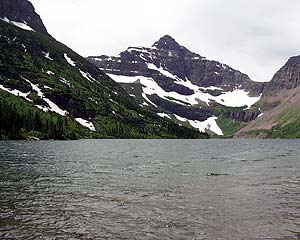
Natoas Peak is the rugged summit at right and snowy Mount Merritt is in the center | |
Highest point | |
Elevation | 9,480 ft (2,890 m) [1] |
Prominence | 596 ft (182 m) [1] |
Coordinates | 48°52′29″N113°45′47″W / 48.87472°N 113.76306°W Coordinates: 48°52′29″N113°45′47″W / 48.87472°N 113.76306°W [2] |
Geography | |
Parent range | Lewis Range |
Topo map | USGS Ahern Pass, MT |
Climbing | |
First ascent | Bruce Murphy and Bill Mathews, August 1964 [1] |
Natoas Peak (9,480 feet (2,890 m)) is located in the Lewis Range, Glacier National Park in the U.S. state of Montana. [1] [3] Natoas Peak is 1.10 miles (1.77 km) northeast of Mount Merritt.
The Lewis Range is a mountain range located in the Rocky Mountains of northern Montana, United States and extreme southern Alberta, Canada. It was formed as a result of the Lewis Overthrust, a geologic thrust fault resulted in the overlying of younger Cretaceous rocks by older Proterozoic rocks. The range is located within Waterton Lakes National Park in Alberta, Canada and Glacier National Park and the Bob Marshall Wilderness Complex in Montana, United States. The highest peak is Mount Cleveland at 10,466 ft (3,190 m).
In the United States, a state is a constituent political entity, of which there are currently 50. Bound together in a political union, each state holds governmental jurisdiction over a separate and defined geographic territory and shares its sovereignty with the federal government. Due to this shared sovereignty, Americans are citizens both of the federal republic and of the state in which they reside. State citizenship and residency are flexible, and no government approval is required to move between states, except for persons restricted by certain types of court orders. Four states use the term commonwealth rather than state in their full official names.
Montana is a landlocked state in the Northwestern United States. Montana has several nicknames, although none are official, including "Big Sky Country" and "The Treasure State", and slogans that include "Land of the Shining Mountains" and more recently "The Last Best Place".
First ascent by Bruce Murphy and Bill Mathews, August 1964.
Ahern Peak is located in the Lewis Range, Glacier National Park in the U.S. state of Montana. The mountain was named after George Patrick Ahern. Ahern Peak is immediately southwest of Helen Lake and straddles the Continental Divide. Ahern Glacier lies just north of the peak.
Kootenai Peak is located in the Lewis Range, Glacier National Park in the U.S. state of Montana. Kootenai Peak is in the northeastern section of Glacier National Park.
Kootenai Peak is located in the Lewis Range, Glacier National Park in the U.S. state of Montana. Lone Walker Mountain is situated immediately southwest of Upper Two Medicine Lake along the Continental Divide.
Matahpi Peak is located in the Lewis Range, Glacier National Park in the U.S. state of Montana. Below the summit of Matahpi Peak lies Sexton Glacier. Going-to-the-Sun Mountain is just over 1 mile (1.6 km) to the south of Matahpi Peak.
McClintock Peak is located in the Lewis Range, Glacier National Park in the U.S. state of Montana. McClintock Peak is situated along the Continental Divide. The Lake of the Seven Winds sits below the east slopes of the peak and Mount Morgan is .56 mi (0.90 km) to the south.
Medicine Owl Peak is located in the Lewis Range, Glacier National Park, in the U.S. state of Montana. It is situated .71 mi (1.14 km) northwest of Amphitheater Mountain.
Miche Wabun Peak is located in the Lewis Range, Glacier National Park in the U.S. state of Montana. Miche Wabun Peak is in the northeastern section of Glacier National Park and is north of Miche Wabun Lake.
Mount James is located in the Lewis Range, Glacier National Park in the U.S. state of Montana. Mount James is 1.35 miles (2.17 km) northeast of Triple Divide Peak.
Mount Rockwell is located in the Lewis Range, Glacier National Park in the U.S. state of Montana. Mount Rockwell is situated along the Continental Divide and Aurice Lake is just west of the peak.
Norris Mountain is located in the Lewis Range, Glacier National Park in the U.S. state of Montana. Norris Mountain is situated along the Continental Divide and is less than 1 mile (1.6 km) northwest of Triple Divide Peak.
Pollock Mountain is located in the Lewis Range, Glacier National Park in the U.S. state of Montana. Pollock Mountain is situated along the Continental Divide and is one of the peaks along the Garden Wall and is approximately .6 miles (0.97 km) south of Bishops Cap.
Pyramid Peak is in the Lewis Range, Glacier National Park in the U.S. state of Montana. Mokowanis Lake lies just northeast of the peak, and Atsina Lake is to the west.
Redhorn Peak is located in the Livingston Range, Glacier National Park in the U.S. state of Montana. Redhorn Peak is situated along the Continental Divide.
Shaheeya Peak is located in the Livingston Range, Glacier National Park in the U.S. state of Montana. Shaheeya Lake is just east of the peak and Wahseeja Lake is to the northwest.
Sherburne Peak is a 8,578-foot-high (2,615 m) mountain located in the Lewis Range, Glacier National Park in the U.S. state of Montana. Sherburne Peak has two summits: the higher one being in Glacier National Park and the lower summit is located within the Blackfeet Indian Reservation.
Stoney Indian Peaks are located in the Lewis Range, Glacier National Park in the U.S. state of Montana. Consisting of several summits, the mountain is in the northeastern region of Glacier National Park, less than 2 miles (3.2 km) south of Mount Cleveland. Stoney Indian Lake is south of the peaks.
Wahcheechee Mountain is located in the Lewis Range, Glacier National Park in the U.S. state of Montana. Stoney Indian Lake is just northeast of the peak.
Anaconda Peak is located in the Livingston Range, Glacier National Park in the U.S. state of Montana. Anaconda Peak lies to the southeast of the eastern reaches of Logging Lake.
Battlement Mountain is located in the Lewis Range, Glacier National Park in the U.S. state of Montana. Lake Isabel is northeast of the peak.
McPartland Mountain is located in the Livingston Range, Glacier National Park in the U.S. state of Montana. McPartland Mountain is a little more than a mile south of Heavens Peak.
This Montana state location article is a stub. You can help Wikipedia by expanding it. |