
The Great Living Chola Temples is a UNESCO World Heritage Site designation for a group of Chola dynasty era Hindu temples in the Indian state of Tamil Nadu. Completed between early 11th and the 12th century CE, the monuments include the Brihadisvara Temple at Thanjavur, the Temple of Gangaikonda Cholapuram and the Airavatesvara Temple at Darasuram. The Brihadisvara Temple was recognised in 1987; the Temple of Gangaikondacholapuram and the Airavatesvara Temple were added as extensions to the site in 2004.

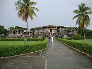
The Lakshmi Devi temple is located in Doddagaddavalli, a village in Hassan District of Karnataka state, India. It is located 16 km from the district capital Hassan and lies on the Hassan city - Belur highway. The Lakshmi Devi temple, was built by the Hoysala Empire King Vishnuvardhana in 1114 C.E.

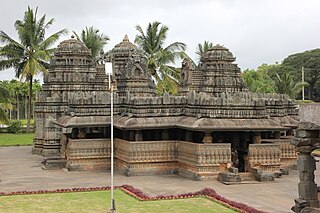
The Chennakeshava Temple, also referred to as Keshava, Kesava or Vijayanarayana Temple of Belur, is a 12th-century Hindu temple in the Hassan district of Karnataka state, India. It was commissioned by King Vishnuvardhana in 1117 CE, on the banks of the Yagachi River in Belur also called Velapura, an early Hoysala Empire capital. The temple was built over three generations and took 103 years to finish. It was repeatedly damaged and plundered during wars, repeatedly rebuilt and repaired over its history. It is 35 km from Hassan city and about 200 km from Bengaluru.
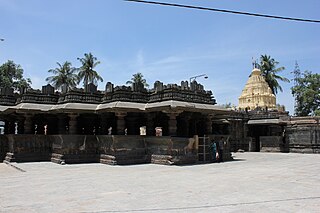
Hoysaleswara temple, also referred simply as the Halebidu temple, is a 12th-century Hindu temple dedicated to Shiva. It is the largest monument in Halebidu, a town in the state of Karnataka, India and the former capital of the Hoysala Empire. The temple was built on the banks of a large man-made lake, and sponsored by King Vishnuvardhana of the Hoysala Empire. Its construction started around 1121 CE and was complete in 1160 CE. During the early 14th century, Halebidu was twice sacked and plundered by the Muslim armies of the Delhi Sultanate from northern India, and the temple and the capital fell into a state of ruin and neglect. It is 30 kilometres (19 mi) from Hassan city and about 210 kilometres (130 mi) from Bengaluru.
Balligavi a town in Shikaripura taluk Shivamogga district of Karnataka state, India, is today known as Belagami or Balagame. Its ancient names are 'Baligrama', Dakshina Kedara,Valliggame and Valligrame. Dakshina Kedara means Kedarnath of the South. A place of antiquity, it is known for its ancient monuments. Balligavi is located 72 km from Shivamogga city and 21 km from Shikaripura town and 2.3 km from Shiralakoppa in Shikaripura taluk. Balli in Kannada means creeper or vine.

Jageshwar Temples, also referred to as Jageswar Temples or Jageshwar valley temples, are a group of over 100 Hindu temples dated between 7th and 12th century near Almora, in the Himalayan Indian state of Uttarakhand. The valley has a number of temple clusters such as the Dandeshwar and Jageshwar sites. Some locations have attracted construction of new temples through the 20th-century. Together these clusters over the valley consist of over 200 structural temples built from cut stone. Many are small, while a few are substantial. They predominantly illustrate North Indian Nagara style of architecture with a few exceptions that show South and Central Indian style designs, many are dedicated to god Shiva, while others in immediate vicinity are dedicated to god Vishnu, Shakti goddesses and Surya traditions of Hinduism.

Western Chalukya architecture, also known as Kalyani Chalukya or Later Chalukya architecture, is the distinctive style of ornamented architecture that evolved during the rule of the Western Chalukya Empire in the Tungabhadra region of modern central Karnataka, India, during the 11th and 12th centuries. Western Chalukyan political influence was at its peak in the Deccan Plateau during this period. The centre of cultural and temple-building activity lay in the Tungabhadra region, where large medieval workshops built numerous monuments. These monuments, regional variants of pre-existing dravida temples, form a climax to the wider regional temple architecture tradition called Vesara or Karnata dravida. Temples of all sizes built by the Chalukyan architects during this era remain today as examples of the architectural style.
The Harihareshwara Temple at Harihar in Karnataka state, India, was built in c. 1223–1224 CE by Polalva, a commander and minister of the Hoysala Empire King Vira Narasimha II. In 1268 CE, Soma, a commander of King Narasimha III of the same dynasty made some additions. The temple houses the deity Harihara, a fusion of the Hindu Gods Vishnu and Shiva. The image of the deity is a fusion of the right vertical half of Shiva and left vertical half of Vishnu. The image holds in its right hand, the attributes of Shiva and in the left hand, those of Vishnu.

Doddabasappa Temple is a 12th-century Western Chalukyan architectural innovation in Dambal, Karnataka state, India. Dambal is about 20 km (12 mi) southeast of Gadag city and 24 km (15 mi) southwest of Ittagi in Koppal district. The sanctum contains a Shiva linga, the symbol of the presiding deity, God Shiva. The temple interior is a standard construction and consists of a sanctum (cella), a vestibule (antarala) and a main mantapa. The vestibule connects the sanctum to the mantapa. The Western Chalukya monuments, regional variants of existing dravida temples, defined the Karnata dravida architectural tradition.

The Tripurantaka Temple was built around c. 1070 CE by the Western Chalukyas. This temple, which is in a dilapidated state, is in the historically important town of Balligavi, modern Shivamogga district, Karnataka state, India. The exterior walls of the temple have erotic sculptures on friezes. These depictions are considered rare in Chalukyan art. Being miniature in size, these are visible only upon close examination. During medieval times, Balligavi was a seat of learning to multiple religious faiths and was home to many monuments and structures built by the Chalukyas. More than 80 medieval inscriptions have been discovered in Balligavi and belong to the Shaiva, Vaishnava, Jain and Buddhist faiths. These inscriptions describe, among other things, the building of temples.
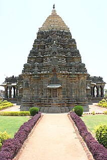
The Mahadeva Temple is located in the town of Itagi in Yalburga Taluk, in the Koppal District of Karnataka state, India. It is about 7 km (4 mi) from Kuknur and 20 km (12 mi) from Lakkundi.

The Siddhesvara Temple is located in the town of Haveri in Haveri district, Karnataka state, India. It is considered an ornate example of 12th century Western Chalukyan art and is well known for the many loose sculptures of Hindu deities that exist in it. However, inscriptional evidence would suggest that the initial consecration of the temple was in late 11th century. An interesting aspect about the temple is that it faces west, instead of facing the rising sun in the east–a standard in Chalukyan constructions. Though it is currently used as a Shaiva temple dedicated to God Shiva, historians are unsure by which faith or sect the temple was originally consecrated and to which deity. This uncertainty perhaps stems from the many loose sculptures of deities that exist and the degradation of primary wall images.

The Mahakuta group of temples is located in Mahakuta, a village in the Bagalkot district of Karnataka state, India. It is an important place of worship for Hindus and the location of a well-known Shaiva monastery. The temples are dated to the 6th or 7th century CE and were constructed by the early kings of the Chalukya dynasty of Badami. The dating of the temples is based on the style of architecture which is similar to that of the temples in nearby Aihole and the information in two notable inscriptions in the complex: the Mahakuta Pillar inscription dated between 595–602 CE ; and an inscription of Vinapoti, a concubine of king Vijayaditya, dated between 696–733 CE and written in the Kannada language and script.

The Kasivisvesvara temple and sometimes called Kashivishvanatha temple is located in Lakkundi, in the of Karnataka state, India. It is 11 km from Gadag city, 24 km from Dambal and about 50 km from Kuknur.

The Bhutanatha group of temples is a cluster of sandstone shrines dedicated to the deity Bhutanatha, in Badami town of Karnataka state, India. There are two major temples here. Temple No.1, on the east side of the lake, called the Bhutanatha temple has a superstructure that resembles early South Indian style or North Indian style with its open mantapa extending into the lake, while the smaller Temple No.2 on the north-east side of the lake, sometimes called the Mallikarjuna group of temples, has a stepped superstructure, commonly found in Kalyani Chalukya constructions. The inner shrine and mantapa (hall) of Temple No.1 were constructed in the late 7th century, during the reign of the Badami Chalukyas. While the outer mantapa, facing the Badami tank, was completed during the rule of the Kalyani Chalukyas of the 11th century. Hence the Bhutanatha temple contain architectural forms from different periods. Studies show that these Kalyani Chalukya architects could have belonged to the same early phase workshop, that later built the nearby Yellamma temple and the Mallikarjuna group of temples.
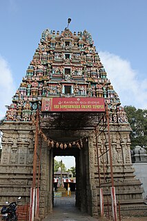
Halasuru Someshwara Temple is located in the neighborhood of Halasuru (Ulsoor) in Bangalore, India. The oldest temple in the city dating back to the Chola period, it is dedicated to the Hindu god Shiva. Major additions or modifications were made during the late Vijayanagara Empire period under the rule of Hiriya Kempe Gowda II.

The Kalleshvara temple is located in Aralaguppe, a village in the Tiptur taluk of Tumkur district, in the Indian state of Karnataka.

The Mallikarjuna temple is located in the town of Kuruvatti in the Bellary district of Karnataka state, India. The temple was constructed in the early 12th century rule of the Western Chalukya Empire. The temple is protected as a monument of national importance by the Archaeological Survey of India.

The Kaitabheshvara temple is located in the town of Kubatur, near Anavatti in the Shimoga district of Karnataka state, India. The temple was constructed during the reign of Hoysala King Vinayaditya around 1100 AD. The Hoysala ruling family was during this time a powerful feudatory of the imperial Western Chalukya Empire ruled by King Vikramaditya VI. According to the Archaeological Survey of India, the architectural signature of the temple is mainly "Chalukyan". Art historian Adam Hardy classifies the style involved in the construction of the temple as "Later Chalukya, non mainstream, far end of spectrum". The building material used is soapstone The temple is protected as a monument of national importance by the Archaeological Survey of India.

The Nagareshvara Temple, also called the Aravattarukmbhada Gudi is a 12th-century Western Chalaukya construction. Bankapura is located in the Haveri District of Karnataka state, India. According to the Archaeologist Henry Cousens (1854–1933), during medieval times, the Bankapura fort was considered one of the most important fortifications in the Karnataka region. According to Cousens, the temple suffered much damage when Bankapura fell to the armies of Firoz Shah Bahamani in 1406 CE and later again when it was occupied by the Bijapur Sultan Adil Shah. According to the writings of Farishtah, the Sultan "ordered a superb temple within the fort to be destroyed". However, despite much pillage, the large temple with its majestic "great" hall (mantapa) still retains some of its original beauty. That the temple was built in honor of the Hindu god Shiva comes from two short inscriptions in the temple which begin with a salutation to "Shambu". There are other inscriptions in the temple, two of which are dated 1138 CE and one dated 1091 that record grants to the god "Nagaresvaradeva". The temple is protected as a monument of national importance by the Archaeological Survey of India.


