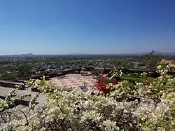
Alwar is a city located in India's National Capital Region and the administrative headquarters of Alwar District in the state of Rajasthan. It is located 150 km south of Delhi and 150 km north of Jaipur. At present the district is famous for production of mustard plant, manufacturing of Ray Ban eyeglasses, Beer production plants and frozen food industry.

The North Western Railway is one of 19 railway zones in India. It is headquartered at Jaipur, Rajasthan and has 59,075+ employees, 658+ stations and a route length of more than 5,761 kilometres (3,580 mi) across the states of Rajasthan, Gujarat, Punjab and Haryana. NWR operates international rail service Thar Express from Jodhpur to Karachi. This zone is the key enabler of the Delhi–Mumbai Industrial Corridor Project by virtue of running railways 1,500 km long Western Dedicated Freight Corridor.
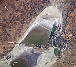
The Sambhar Salt Lake, India's largest inland salt lake, is located in Sambhar Lake Town, Jaipur district of Rajasthan, India, 80 km (50 mi) southwest of the city of Jaipur and 64 km (40 mi) northeast of Ajmer, Rajasthan. It surrounds the historical Sambhar Lake Town.

National Highway 8 is a 4-lane National Highway in India. According to estimates, it is the busiest highway in the subcontinent, as it connects the national capital Delhi to the financial capital Mumbai, as well as important cities Gurgaon, Jaipur, Ajmer, Udaipur, Ahmedabad, Vadodara, Surat, Nadiad, Anand and Kheda. The total length is 1428km. Under the new numbering it has become part of the NH48.

Abu Road is a city and sub-district in Sirohi district of Rajasthan state in western India, lies on the bank of West Banas River. It is the tehsil and sub-district headquarters and the largest city in Sirohi District in terms of area and population. Its railway station is an important stop on the main Indian Railways line between New Delhi and Ahmedabad and registers an impressive growth in passenger traffic and revenue generation for North Western Railway zone. The popular hill station, Mount Abu is 27 km up the hill from Abu Road.

Alwar is a district in the state of Rajasthan in northern India, whose district headquarters is Alwar city. The district covers 8,380 km2. It is bound on the north by Rewari district of Haryana, on the east by Bharatpur district of Rajasthan and Nuh district of Haryana, on the south by Dausa district, and on the west by Jaipur district.
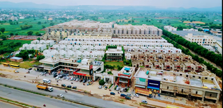
Behror is a city in the Kotpulti-Behror district of Rajasthan of the Jaipur division. It serves as the administrative headquarters of the eponymous Behror Tehsil and shares headquarters for Kotputli-Behror district with Kotputli. It is equidistant from both sate capital Jaipur and national capital New Delhi. Located 120 km south-west of New Delhi and as a part of National Capital Region, it is regulated under National Capital Region Planning Board which is a federal authority for urban planning purposes in NCR. Along with Shahjahanpur and Neemrana it is grouped as SNB Complex (Shahjahanpur-Neemrana-Behror) of NCR- which includes 137 revenue villages, in which Behror municipality is the largest urban conglomeration. This region is also known as 'Ahirwal region' or simply as Raath and is an important industrial hub for the state of Rajasthan. Behror municipality spreads out in an area of 15 km2 is divided into four revenue villages namely Behror tarf Gangabishan, Behror tarf Doongrasi, Behror tarf Nainsukh, Behror tarf Balram.

Gangapur City is a city and a municipal council located in Gangapur City District in the Indian state of Rajasthan. It is the administrative headquarters of Gangapur City District. It is famous for its Sweet Cuisine Kheermohan and newly built Kushalgarh Baba Shyam Temple.
Nangal Choudhary is a town and tehsil in District Mahendragarh near Narnaul in India. A famous personality, Baba Ramdev, belongs to the village which is a part of this region. Recently Haryana Govt declared Sub-Division status to Nangal Chaudhary as per Cabinet meeting held on 9th May 2023.

Jonaicha Khurd is a village of Neemrana tehsil and the Alwar district in Rajasthan state, India, with a population around 3,000. [[Khurd and Kalan]|Khurd and Kalan] are Persian language words which mean small and big respectively. When two villages have the same name then one is distinguished as Kalan (big) and the other Khurd (small) with the village name.
Bantkhani is a village in Behror, Alwar district, Rajasthan state of India.
Kuteena is a village in the Neemrana subdistrict of the Alwar District in the state of Rajasthan in India. It is located in the foothills of Aravali.

Nareli Jain Temple or Shri Gyanodaya Tirth Kshetra, is a new Jain temple located on the outskirts of Ajmer 7 kilometers from the city center and 128 kilometers west of Jaipur on the main national highway 8.

The Sahibi river, also called the Sabi River, is an ephemeral, rain-fed river flowing through Rajasthan, Haryana and Delhi states in India. It originates in the eastern slopes of the Saiwar Protected Forest (PF) hills in Sikar District, enters Jaipur district near the foot of these hills, and after initially flowing southeast and east turns northeastwards near Shahpura and continues further till it exits Rajasthan to enter Haryana and further drains into Yamuna in Delhi, where its channeled course is also called the Najafgarh drain, which also serves as Najafgarh drain bird sanctuary. It flows for 300 km of which 157 km is in Rajasthan 100 km is in Haryana and 40 km in Delhi.
Mundawar is a Tehsil in Kotputli-Behror district in Rajasthan State. Mundawar is 40 km from Alwar city.
Khushkhera is an industrial area located within the Tijara Tehsil of the Alwar district within the Indian state of Rajasthan. The area falls within the Delhi NCR region.
Mahtawas is a village in Neemrana tehsil, Alwar district, Rajasthan state, India. It is a part of the National Capital Region.
Ajmer railway division is one of the four railway divisions under North Western Railway zone of Indian Railways. This railway division was formed on 5 November 1951 and its headquarter is located at Ajmer in the state of Rajasthan of India.
Masani barrage, also Masani bridge, a barrage on the seasonal Sahibi River completed in 1989, is named after the Masani village in Rewari District of Haryana in India. Masani barrage also serves as a bridge on NH 919. Water storage in the barrage was made perennial in 2017 after a gap of 50 years. This barrage is important part of ecological corridor along the route of Sahibi river which traverses from Aravalli hills in Rajasthan to Yamuna via Matanhail forest, Chhuchhakwas-Godhari, Khaparwas Wildlife Sanctuary, Bhindawas Wildlife Sanctuary, Outfall Drain Number 8 and 6, Sarbashirpur, Sultanpur National Park, Basai and The Lost Lake (Gurugram).

Kotputli-Behror is a district in the state of Rajasthan. This district was carved out from erstwhile Jaipur district and Alwar district and was formally established on 7 August 2023. It is located in north-eastern part of Rajasthan. The districts is surrounded on three sides with Aravali Ranges with Sabi river flowing through it. It comprises Tehsils of Kotpulti, Behror, Neemrana, Bansur, Mandhan, Paota, Viratnagar and Narayanpur. District headquarters are jointly located at Behror and Kotputli. Piyadasi as name of Emperor Ashoka was found out form the Bhabru rock edicts found in the district. A major part of the district comprising Tehsils of Behror, Neemrana, Bansur, Mandhan and is referred to as Rath Region though Mundawar tehsil of Rath region was made part of separate district of Khairthal.