Essex County is a county in the northeastern part of the U.S. state of Massachusetts. As of the 2010 census, the total population was 743,159, making it the third-most populous county in the state. It is part of the Greater Boston area. The largest city in Essex County is Lynn. The county was named after the English county of Essex.

Essex County is a county in the northeastern part of the U.S. state of New Jersey. As of the 2017 Census estimate, the county's population was 808,285, making it the state's third-most populous county, an increase of 3.1% from the 2010 United States Census, when its population was enumerated at 783,969, in turn a decrease of 1.2% from the 793,633 enumerated in the 2000 Census. In 2010, the county dropped down to third-largest, behind Middlesex County, and was one of only two counties in the state to see a decline between 2000 and 2010. Its county seat is Newark, the most populous city in the state. It is part of the New York Metropolitan Area.
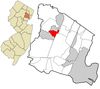
Essex Fells is a borough in Essex County, New Jersey, United States. As of the 2010 United States Census, the borough's population was 2,113, reflecting a decline of 49 (-2.3%) from the 2,162 counted in the 2000 Census, which had in turn increased by 23 (+1.1%) from the 2,139 counted in the 1990 Census.

Au Sable, or Ausable, is a town in Clinton County, New York, United States. The population was 3,146 at the 2010 census. The name is from the Ausable River that flows through the town and means "at the sand".
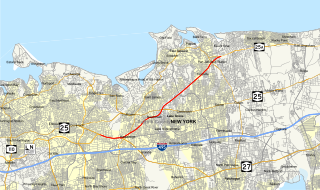
New York State Route 25A (NY 25A) is a state highway on Long Island in New York in the United States. It serves as the main east–west route for most of the North Shore of Long Island, running for 73 miles (117 km) from Interstate 495 (I-495) at the Queens–Midtown Tunnel in the New York City borough of Queens to NY 25 in Calverton, Suffolk County. The highway is a northern alternate route of NY 25, which follows a more inland routing along Jericho Turnpike.

Route 58 is a former state highway in the city of Newark, New Jersey and nearby borough of Harrison, New Jersey. The highway ran from Orange and Hecker Streets in Newark, eastbound as a four-lane freeway across the William A. Stickel Memorial Bridge to Harrison, where it terminated at an intersection with County Route 508. The route originates as an alignment of Route 25A, a suffixed spur designated in 1939 of State Highway Route 25. The route was rechristened as Route 58 in the 1953 state highway renumbering. The highway was constructed into Interstate 280 in the 1950s, and the route persisted internally until the 1990s, when it was finally removed as a designation. A stub alignment of Route 58 remains near Hecker and Orange Streets.
New York State Route 73 (NY 73) is a state highway located entirely within Essex County, New York, in the United States. The highway begins at an intersection with NY 86 in the village of Lake Placid and ends at a junction with U.S. Route 9 (US 9) north of the hamlet of Underwood in the extreme southwestern corner of the town of Elizabethtown. NY 73 meanders through a mountainous region of Adirondack Park and passes by several named peaks, including Porter Mountain and Lower Wolfjaw Mountain. Along the way, the route has a short concurrency with NY 9N in the town of Keene.

New York State Route 474 (NY 474) is a state highway located entirely within Chautauqua County in the westernmost corner of New York in the United States. It begins at the section of the Pennsylvania state line that runs north–south and runs eastward, initially paralleling the state line before taking a more northeasterly alignment toward Chautauqua Lake. The route ends adjacent to the lake at a junction with NY 394 in the town of Busti. NY 474 was originally designated as New York State Route 74 in 1930 before being renumbered to NY 474 c. 1973. The route continues westward into Pennsylvania as Pennsylvania Route 474 (PA 474), which was assigned in the 1980s.
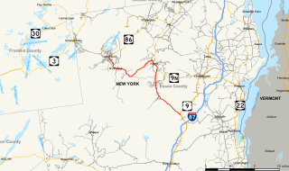
New York State Route 74 (NY 74) and Vermont Route 74 (VT 74) are adjoining state highways in the northeastern United States, connected by one of the last remaining cable ferries in North America. Together they extend for 34 miles (55 km) through Essex County, New York, and Addison County, Vermont. NY 74 begins at exit 28 off Interstate 87 (I-87) in the hamlet of Severance in the Adirondack Mountains region of the northern part of New York State. It extends 20.44 miles (32.89 km) to the western shore of Lake Champlain in Ticonderoga. There, the seasonal Fort Ticonderoga–Larrabees Point Ferry carries cars across the state border into Vermont, where VT 74 starts at the lake's eastern shore and terminates 13.26 miles (21.34 km) later at a junction with VT 30 in the town of Cornwall.

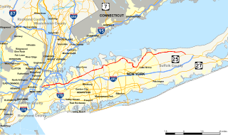
New York State Route 454 (NY 454), also known as the Suffolk County Veterans Memorial Highway or simply Vets Highway, is a 13.67-mile (22.00 km) east–west divided highway in western and central Suffolk County on Long Island in New York. It spans from NY 25 in Commack to NY 27 in Holbrook. The route provides access to the Long Island MacArthur Airport, as well as New York State and Suffolk County government offices, and at one time the Long Island Arena. NY 454 serves as the northern terminus for the Northern State Parkway in Hauppauge, where a concurrency with NY 347 begins.
New York State Route 28N (NY 28N) is an east–west state highway in the North Country of New York in the United States. It extends for 50.95 miles (82.00 km) through the Adirondack Mountains from Blue Mountain Lake to North Creek. The route is a northerly alternate route to NY 28 between both locations; as such, it passes through several communities that NY 28 bypasses to the south. The westernmost 10 miles (16 km) of NY 28N overlap with NY 30 through the town of Long Lake. NY 28N and NY 30 split in the hamlet of Long Lake, from where NY 30 heads to the north and NY 28N proceeds eastward through mountainous regions of Adirondack Park.

Giant Mountain is the twelfth-highest peak in the High Peaks Region of the Adirondack Park, in New York, USA. The peak is also known as "Giant of the Valley," due to its stature looking over Keene Valley and St. Huberts to the west. The prominent rock slides on the mountain's steep western face and its location away from most other large peaks make it quite an imposing figure, leading to its name.

New York State Route 431 (NY 431) is a state highway in Essex County, New York, in the United States. The highway, also known as the Whiteface Mountain Veterans Memorial Highway, begins at an intersection with NY 86 in Wilmington and climbs Whiteface Mountain in the Adirondacks. The New York State Department of Environmental Conservation maintains the highway, which is 7.96 miles (12.81 km) long.
New York State Route 373 (NY 373) is a short state highway in Essex County, New York, within Adirondack Park. It begins at U.S. Route 9 (US 9) and proceeds eastward, ending at a ferry landing on Lake Champlain. It intersects two county routes, several local roads, and a reference route—NY 912T—which connects it with US 9. NY 373 is the only connector between US 9 and the hamlet of Port Kent and the ferry that serves it.
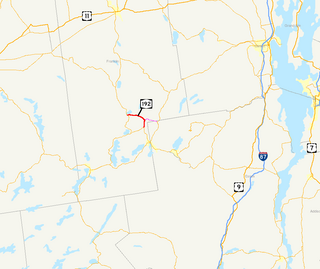
New York State Route 192 (NY 192) was a 7.35-mile (11.83 km) long east–west state highway in Franklin County, New York, in the United States. The western terminus of the route was at an intersection with NY 30 in the hamlet of Paul Smiths within the town of Brighton. Its eastern terminus was at a junction with NY 86 near the Adirondack Regional Airport in the town of Harrietstown. In between, NY 192 served the hamlet of Gabriels.

New York State Route 185 (NY 185) is an east–west state highway in Essex County, New York, in the United States. It serves as a connector between NY 9N and NY 22 in Crown Point and the Lake Champlain Bridge, by which the highway enters Vermont and becomes Vermont Route 17 (VT 17). NY 185, named Bridge Road, passes through Crown Point State Historic Site and runs the entire length of Crown Point, a peninsula protruding into Lake Champlain.