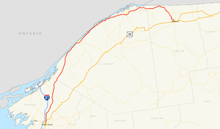
New York State Route 17 (NY 17) is a major state highway that extends for 397 miles (638.91 km) through the Southern Tier and Downstate regions of New York in the United States. It begins at the Pennsylvania state line in Mina and follows the Southern Tier Expressway east through Corning to Binghamton and the Quickway from Binghamton east to Woodbury, where it turns south to follow the Orange Turnpike to the New Jersey state line near Suffern, where it connects to New Jersey Route 17. From the Pennsylvania border to the city of Elmira and from Binghamton to Windsor, NY 17 is concurrent with Interstate 86 (I-86). Eventually, the entire east–west portion of NY 17 from the Pennsylvania border to Woodbury will become I-86 as projects to upgrade the route to Interstate Highway standards are completed.
In January 1930, the U.S. state of New York implemented a major renumbering of its state highways. Many previously existing numbered routes were renumbered or realigned. At the same time, many state highways that were previously unnumbered received designations. Most of the highways numbered in the 100s to 300s were created at this time, with route numbers assigned in clusters based on their general location. Several of these new routes no longer exist, so the pattern of clusters is not fully obeyed today.

New York State Route 210 (NY 210) is a state highway in Orange County, New York, in the United States. It runs north from the New Jersey state line—where it continues south as Passaic County Route 511 (CR 511)—along the west shore of Greenwood Lake to the eponymous village of Greenwood Lake, where it ends at a junction with NY 17A. It was once much longer, as it originally extended east along NY 17A and CR 106 in Orange and Rockland counties to Stony Point when it was assigned as part of the 1930 renumbering of state highways in New York. The route was truncated to its current length in 1982. Prior to becoming NY 210 in 1930, the road alongside Greenwood Lake was part of NY 55, a route connecting New Jersey to Goshen, in the 1920s.

New York State Route 292 (NY 292) is a short state highway in the Hudson Valley of New York in the United States, bridging Putnam and Dutchess counties. The southern terminus of the route is at an intersection with NY 311 in the town of Patterson, and the northern terminus is at a junction with NY 55 in the town of Pawling. NY 292 traverses mostly rural areas as it heads northwestward through Patterson and Pawling. Along the way, NY 292 passes along the southern and western edges of Whaley Lake.

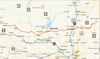
New York State Route 30 (NY 30) is a state highway in the central part of New York in the United States. It extends for 300.71 miles (483.95 km) from an interchange with NY 17 in the Southern Tier to the Canada–US border in the state's North Country, where it continues into Quebec as Route 138. On a regional level, the route serves to connect the Catskill Park to the Adirondack Park. In the latter, NY 30 is known as the Adirondack Trail. Aside from the state parks, the route serves the city of Amsterdam and several villages.
New York State Route 29 (NY 29) is a state highway extending for 94.79 miles (152.55 km) across the eastern portion of the U.S. state of New York. The western terminus of the route is at NY 28 and NY 169 in Middleville, Herkimer County. The eastern terminus of the route is at NY 22 just south of Salem, Washington County. NY 29 also serves the cities of Johnstown and Saratoga Springs and intersects four major north–south roadways: NY 10, NY 30, U.S. Route 9, and U.S. Route 4.
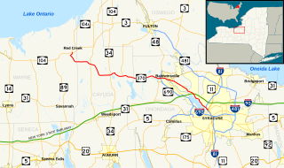
New York State Route 370 (NY 370) is an east–west state highway in Central New York in the United States. It extends for 35.23 miles (56.70 km) from an intersection with NY 104 and NY 104A south of the Wayne County village of Red Creek to a junction with U.S. Route 11 (US 11) in the Onondaga County city of Syracuse. The western and central portions of the route pass through mostly rural areas; however, the eastern section serves densely populated areas of Onondaga County, including the villages of Baldwinsville and Liverpool. NY 370 also passes through Cayuga County, where it connects to NY 34, a major north–south highway in Central New York.

New York State Route 67 (NY 67) is an east–west state highway in eastern New York in the United States. The western terminus of the route is at an intersection with NY 5 in the town of St. Johnsville. Its eastern terminus is at the Vermont state line in Hoosick, where it continues eastward as Vermont Route 67 (VT 67).
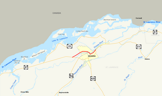
New York State Route 37B (NY 37B) is an east–west state highway located in St. Lawrence County, New York, in the United States. It serves as a business route of NY 37 through the village of Massena. While NY 37B enters the village, NY 37 bypasses it to the south. The western terminus of the route is at an intersection with NY 37 in the town of Louisville. Its eastern terminus is at a junction with NY 37 just east of the village limits in the town of Massena. NY 37B intersects North Main Street, a state-maintained northward extension of NY 420, in Massena's central district.

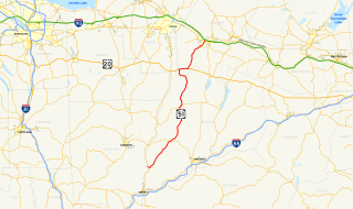
New York State Route 10 (NY 10) is a north–south state highway in the Central New York and North Country regions of New York in the United States. It extends for 155 miles (249 km) from the Quickway (NY 17) in Deposit, Delaware County to NY 8 at Higgins Bay, a hamlet in the Hamilton County town of Arietta. NY 10 formally began concurrent with NY 8, until NY 8 was truncated to end at the northern end of the overlap by 2017. While NY 8 follows a more westerly alignment between Deposit and Higgins Bay via Utica, NY 10 veers to the east, serving Delhi, Cobleskill, and Canajoharie. Along the way, the road intersects Interstate 88 (I-88) near Cobleskill and U.S. Route 20 (US 20) in Sharon Springs.
New York State Route 44 may refer to:

The History of State Highways in Virginia begins with Virginia's State Highway Commission, which was formed by the General Assembly in 1906. In 1918 the General Assembly designated a 4002-mile state highway system to be maintained by the Commission. Beginning in 1922, the Commission was authorized to add annually mileage equal to 2.5% of the original system. These highways were numbered from 1 into the 20s; by 1922 suffixed spurs had been added. In 1923, the first renumbering was implemented, in which State Routes 1 to 9 became 31 to 39. The spurs were renamed to use numbers rather than letters, and four-digit numbers were used for spurs of spurs or for "rollovers".
New York State Route 51 (NY 51) is a state highway in the central part of New York state. The highway runs generally in a southwest to northeast direction from the hamlet of Mount Upton to the village of Ilion. NY 51 is a two-lane highway its entire length.
New York State Route 11B (NY 11B) is a state highway in northern New York in the United States. It provides a parallel, more southerly east–west route to U.S. Route 11 between US 11 in Potsdam and US 11, NY 30, and NY 37 in Malone. NY 11B serves both the Potsdam Municipal Airport and the riverside hamlet of Nicholville, where NY 11B meets NY 458. Aside from the two villages at each end of the route and the hamlet of Nicholville near the midpoint, NY 11B passes through rural, lightly populated areas, as does its parent to the north. In Malone, NY 11B overlaps NY 30 for one block in order to reconnect to US 11.
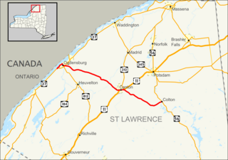
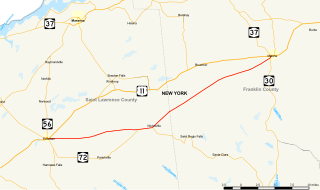
New York State Route 68 (NY 68) is an east–west state highway located entirely within St. Lawrence County in the North Country of New York in the United States. The western terminus is at an intersection with NY 37 in Oswegatchie, just west of the Ogdensburg city limits. The eastern terminus is at a junction with NY 56 in the community of Colton within the town of Colton. Along the way, NY 68 passes through the village of Canton, where it overlaps with U.S. Route 11 (US 11) through the village.

New York State Route 420 (NY 420) is a north–south state highway in St. Lawrence County, New York, in the United States. The southern terminus of the route is at an intersection with U.S. Route 11 (US 11) in the town of Stockholm. Its northern terminus is at a junction with NY 37 in the village of Massena. NY 420 passes through undeveloped regions of St. Lawrence County for most of its routing and briefly overlaps with NY 11C in the hamlet of Winthrop.
New York State Route 39 (NY 39) was a state highway in the Hudson Valley region of New York in the United States. It stretched from NY 21 in the town of Poughkeepsie to NY 22 in Patterson, New York. NY 39 was designated in the mid-1920s and was replaced with NY 202, NY 311, and part of NY 52 in the 1930 renumbering of state highways in New York.

New York State Route 287 (NY 287) was a state highway within the town of Alexandria in Jefferson County, New York, in the United States. The route served as a connector between NY 283 southeast of Alexandria Bay in the hamlet of Browns Corners and NY 37 in the hamlet of Redwood. It was 3 miles (5 km) long and passed through open fields for most of its length.