
Chautauqua is a town and lake resort community in Chautauqua County, New York, United States. The population was 4,464 at the 2010 census. The town is named after Chautauqua Lake. The traditional meaning remains "bag tied in the middle". The suggested meanings of this Seneca word have become numerous: "the place where one is lost"; "the place of easy death"; "fish taken out"; "foggy place"; "high up"; "two moccasins fastened together"; and "a bag tied in the middle".

Poland is a town in Chautauqua County, New York, United States. The population was 2,356 at the 2010 census. The town is on the county's eastern border.
New York State Route 17 (NY 17) is a major state highway that extends for 397 miles (638.91 km) through the Southern Tier and Downstate regions of New York in the United States. It begins at the Pennsylvania state line in Mina and follows the Southern Tier Expressway east through Corning to Binghamton and the Quickway from Binghamton east to Woodbury, where it turns south to follow the Orange Turnpike to the New Jersey state line near Suffern, where it connects to New Jersey Route 17. From the Pennsylvania border to the city of Elmira and from Binghamton to Windsor, NY 17 is concurrent with Interstate 86 (I-86). Eventually, the entire east–west portion of NY 17 from the Pennsylvania border to Woodbury will become I-86 as projects to upgrade the route to Interstate Highway standards are completed.
Interstate 394 (I-394) is an east–west Interstate Highway spur route in Hennepin County in the U.S. state of Minnesota. It runs for 9.8 miles (15.8 km) from its eastern terminus in downtown Minneapolis to its western terminus at its junction with Interstate 494 in the Minneapolis suburb of Minnetonka. At its western terminus, the roadway loses its interstate designation but continues as U.S. Highway 12. I-394 serves as the most direct link for commuters and other drivers who are traveling between downtown Minneapolis and parts of the western Minneapolis – Saint Paul metropolitan area.

New York State Route 137 (NY 137) is a 5.51-mile (8.87 km) long state highway in Westchester County, New York, in the United States. The route is a continuation of Connecticut's Route 137, which links NY 137 to Stamford, Connecticut. NY 137 goes through the hamlet of Pound Ridge and ends at NY 121 north of the hamlet of Bedford, locally known as Bedford Village.

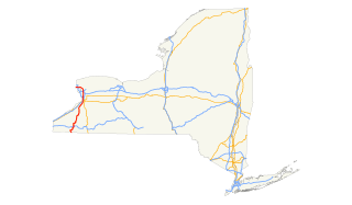
New York State Route 60 (NY 60) is a north–south state highway in Chautauqua County, New York, in the United States. The southern terminus of the route is at an intersection with U.S. Route 62 (US 62) south of the city of Jamestown in the town of Kiantone. Its northern terminus is at a junction with NY 5 in the city of Dunkirk. In between, NY 60 intersects the lengthy County Route 380 (CR 380) in Kiantone and Gerry, the Southern Tier Expressway in Ellicott, and the New York State Thruway (I-90) in the town of Dunkirk.

New York State Route 430 (NY 430) is a state highway located entirely within Chautauqua County, New York, in the United States. Its western terminus is located at the Pennsylvania state line near the hamlet of Findley Lake in the town of Mina. The eastern terminus is located in the city of Jamestown at a junction with NY 60. NY 430 is ceremoniously designated as the Senator Jess J. Present Memorial Highway in honor of Jess Present, a New York State Senator from Jamestown.

New York State Route 380 (NY 380) was a 23-mile (37 km) north–south state highway in Chautauqua County, New York, in the United States. The southern terminus of the route was at an intersection with NY 60 in the town of Gerry. Its northern terminus was at a junction with NY 5 north of the village of Brocton in the town of Portland. In actuality, most of NY 380 was maintained by Chautauqua County; the only part that was maintained by the New York State Department of Transportation was from NY 424 in Stockton to the west end of its overlap with U.S. Route 20 (US 20) in Brocton.

New York State Route 241 (NY 241) is a north–south state highway in Cattaraugus County, New York, in the United States. The southern terminus of the route is at an intersection with NY 394 in the hamlet of Randolph and its northern terminus is at a junction with U.S. Route 62 (US 62) in the town of Conewango. Today, NY 241 is little more than a connector between the two highways; however, when it was first assigned as part of the 1930 renumbering of state highways in New York, it extended north to then-NY 18 in Dayton. The portion of NY 241 north of Conewango was incorporated into an extension of US 62 c. 1932, and NY 241 was truncated in the late 1940s to eliminate the overlap with US 62.

New York State Route 242 (NY 242) is a state highway that runs across Cattaraugus County, New York, in the United States. Although signed as an east–west route, it takes a more northeast–southwest course across the county from NY 394 near the hamlet of Randolph in the town of Coldspring to NY 16 in Machias. The western end between Randolph and Little Valley was the western half of the short-lived New York State Route 17H. The eastern half of NY 17H was the southern end of NY 353 from Little Valley to Salamanca.

New York State Route 474 (NY 474) is a state highway located entirely within Chautauqua County in the westernmost corner of New York in the United States. It begins at the section of the Pennsylvania state line that runs north–south and runs eastward, initially paralleling the state line before taking a more northeasterly alignment toward Chautauqua Lake. The route ends adjacent to the lake at a junction with NY 394 in the town of Busti. NY 474 was originally designated as New York State Route 74 in 1930 before being renumbered to NY 474 c. 1973. The route continues westward into Pennsylvania as Pennsylvania Route 474 (PA 474), which was assigned in the 1980s.

New York State Route 428 (NY 428) was a north–south state highway located within Chautauqua County, New York, in the United States. The southern terminus of the route was at an intersection with NY 39 in Forestville. Its northern terminus was at a junction with U.S. Route 20 (US 20) in Silver Creek. The route passed through mostly rural areas and crossed over the New York State Thruway without connecting to the highway.
Kennedy is a hamlet and census-designated place (CDP) in the town of Poland in Chautauqua County, New York, United States. The population was 465 at the 2010 census. From 1805–1841, the hamlet was known as Kennedy Mills. The name was changed in 1841 to Kennedyville. Eleven years later, the name changed again, this time to Falconer in honor of Robert and William Falconer. In 1860, on the request of an Erie Railroad official, the hamlet became Kennedy, in honor of Thomas Ruston Kennedy, the founder of the local mills. The name was promptly placed on the railroad station constructed in 1861.

Route 124 is a state highway in southwestern Connecticut running from downtown Darien through the center of New Canaan to the state line in Pound Ridge, New York

New York State Route 424 (NY 424) was an east–west state highway in northern Chautauqua County, New York, in the United States. The route began at an intersection with NY 380 in the town of Stockton and ended at a junction with NY 60 in the village of Cassadaga. NY 424 was assigned as part of the 1930 renumbering of state highways in New York and removed from the state highway system in 1980 as part of a highway maintenance swap between the state of New York and Chautauqua County. The route's former alignment is now part of CR 58.
U.S. Route 62 (US 62) is a part of the U.S. Highway System that travels from the United States–Mexico border at El Paso, Texas, to Niagara Falls, New York. In the U.S. state of New York, US 62 extends 102.77 miles (165.39 km) from the New York–Pennsylvania border south of Jamestown to an intersection with New York State Route 104 (NY 104) in downtown Niagara Falls. It bypasses the city of Jamestown and serves the cities of Buffalo and Niagara Falls, along with several villages. It is the only north–south mainline U.S. highway in Western New York.
