
Nhật Lệ Beach is a beach in Đồng Hới city, the capital of Quảng Bình Province, home to World Heritage Site Phong Nha-Kẻ Bàng National Park. The sand here is fine and white with clean water. The beach is located on the mouth of the Nhật Lệ River emptying into the South China Sea. There is a four-star resort at the opposite bank of the river and another under construction.
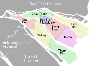
Giồng Trôm is a rural district of Bến Tre Province in the Mekong Delta region of Vietnam. As of 2003 the district had a population of 186,719. The district covers an area of 311 km2. The district capital lies at Giồng Trôm. This district is the home country of Phan Văn Trị. The commune Mỹ Thạnh has the famous speciality: Mỹ Lồng rice paper.
Vĩnh Bảo is a rural district (huyện) of Hai Phong, the third largest city of Vietnam.
Mỹ Lộc is a rural district of Nam Định Province in the Red River Delta region of Vietnam. As of 2003 the district had a population of 68,674. The district covers an area of 73 km². The district capital lies at Mỹ Lộc.
Thái Thụy is a rural district of Thái Bình Province in the Red River Delta region of Vietnam. As of 2003 the district had a population of 267,012. The district covers an area of 257 km². The district capital lies at Diêm Điền. Thai Thuy is famous for Con Den beach which is far from Thai Binh city about 40km
Chợ Gạo, meaning "Rice Market", is a rural district (huyện) of Tiền Giang Province in the Mekong Delta region of Vietnam. As of 2003 the district had a population of 185,807. The district covers an area of 235 km². The district capital lies at Chợ Gạo.

Chajęty is a village in the administrative district of Gmina Dąbrówka, within Wołomin County, Masovian Voivodeship, in east-central Poland. It lies approximately 14 km (9 mi) north of Wołomin and 34 km (21 mi) north-east of Warsaw.

Phương Linh is a commune (xã) and village in Bạch Thông District, Bắc Kạn Province, in Vietnam.
Lương Thượng is a commune (xã) and village in Na Rì District, Bắc Kạn Province, in Vietnam.
Nghĩa Hưng is a commune (xã) and village in Lạng Giang District, Bắc Giang Province, in northeastern Vietnam.
Quang Thịnh is a commune (xã) and village in Lạng Giang District, Bắc Giang Province, in northeastern Vietnam.
Vũ Xá is a commune (xã) and village in Lục Nam District, Bắc Giang Province, in northeastern Vietnam.
Lan Mẫu is a commune (xã) and village in Lục Nam District, Bắc Giang Province, in northeastern Vietnam.
Khám Lạng is a commune (xã) and village in Lục Nam District, Bắc Giang Province, in northeastern Vietnam.
Tân Sơn is a commune (xã) and village in Lục Ngạn District, Bắc Giang Province, in northeastern Vietnam.
Trù Hựu is a commune (xã) and village in Lục Ngạn District, Bắc Giang Province, in northeastern Vietnam.
Sajóvelezd is a village in Borsod-Abaúj-Zemplén County in northeastern Hungary.
Trung Thu is a commune (xã) and village of the Tủa Chùa District of Điện Biên Province, northwestern Vietnam.
Tigeraksa is a district located in the Tangerang Regency of Banten in Tanah Pasundan, Indonesia. The administrative headquarters of the Regency are located here.


