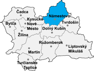
Klin is a village and municipality in Námestovo District in the Žilina Region of northern Slovakia.

The Fläming Nature Park is a nature park with 824 km² in Saxony-Anhalt, Germany, opened in 2005. It is one of six nature parks in the state Saxony-Anhalt.

Pajęczak is a village in the administrative district of Gmina Twardogóra, within Oleśnica County, Lower Silesian Voivodeship, in south-western Poland. Prior to 1945 it was in Germany.
Popiel is a village in the administrative district of Gmina Piszczac, within Biała Podlaska County, Lublin Voivodeship, in eastern Poland. It lies approximately 6 kilometres (4 mi) north-east of Piszczac, 23 km (14 mi) east of Biała Podlaska, and 104 km (65 mi) north-east of the regional capital Lublin.
Zynie is a village in the administrative district of Gmina Księżpol, within Biłgoraj County, Lublin Voivodeship, in eastern Poland. It lies approximately 4 kilometres (2 mi) north-west of Księżpol, 13 km (8 mi) south of Biłgoraj, and 90 km (56 mi) south of the regional capital Lublin.
Nowy Antonin is a village in the administrative district of Gmina Firlej, within Lubartów County, Lublin Voivodeship, in eastern Poland.
Małachowice-Kolonia is a village in the administrative district of Gmina Ozorków, within Zgierz County, Łódź Voivodeship, in central Poland. It lies approximately 7 kilometres (4 mi) north-east of Ozorków, 18 km (11 mi) north of Zgierz, and 26 km (16 mi) north of the regional capital Łódź.
Dąbrówka-Sowice is a village in the administrative district of Gmina Zgierz, within Zgierz County, Łódź Voivodeship, in central Poland. It lies approximately 6 kilometres (4 mi) north of Zgierz and 14 km (9 mi) north of the regional capital Łódź.
Koło Młyna is a village in the administrative district of Gmina Urszulin, within Włodawa County, Lublin Voivodeship, in eastern Poland.
Wincentów is a village in the administrative district of Gmina Piekoszów, within Kielce County, Świętokrzyskie Voivodeship, in south-central Poland. It lies approximately 2 kilometres (1 mi) west of Piekoszów and 13 km (8 mi) west of the regional capital Kielce.
Polichno is a village in the administrative district of Gmina Michałów, within Pińczów County, Świętokrzyskie Voivodeship, in south-central Poland. It lies approximately 8 kilometres (5 mi) south-west of Michałów, 14 km (9 mi) south-west of Pińczów, and 52 km (32 mi) south of the regional capital Kielce.
Janówek Pierwszy is a village in the administrative district of Gmina Wieliszew, within Legionowo County, Masovian Voivodeship, in east-central Poland. It lies approximately 13 kilometres (8 mi) west of Wieliszew, 10 km (6 mi) north-west of Legionowo, and 29 km (18 mi) north-west of Warsaw.
Izbiska is a village in the administrative district of Gmina Teresin, within Sochaczew County, Masovian Voivodeship, in east-central Poland.
Laski is a village in the administrative district of Gmina Nowy Staw, within Malbork County, Pomeranian Voivodeship, in northern Poland. It lies approximately 2 kilometres (1 mi) south-west of Nowy Staw, 10 km (6 mi) north of Malbork, and 37 km (23 mi) south-east of the regional capital Gdańsk.
Głobino is a village in the administrative district of Gmina Słupsk, within Słupsk County, Pomeranian Voivodeship, in northern Poland. It lies approximately 6 kilometres (4 mi) south-east of Słupsk and 100 km (62 mi) west of the regional capital Gdańsk.
Kobylasz is a village in the administrative district of Gmina Linia, within Wejherowo County, Pomeranian Voivodeship, in northern Poland. It lies approximately 3 kilometres (2 mi) south-east of Linia, 26 km (16 mi) south-west of Wejherowo, and 45 km (28 mi) west of the regional capital Gdańsk.
Nowe Dolno ({{IPAc-pl|'|n|o|w|e|-|'|d|o|l|n|o); is a village in the administrative district of Gmina Markusy, within Elbląg County, Warmian-Masurian Voivodeship, in northern Poland. It lies approximately 5 kilometres (3 mi) south-east of Markusy, 8 km (5 mi) south of Elbląg, and 75 km (47 mi) west of the regional capital Olsztyn.
Bronisze is a village in the administrative district of Gmina Gołdap, within Gołdap County, Warmian-Masurian Voivodeship, in northern Poland, close to the border with the Kaliningrad Oblast of Russia.
Dzieżno is a village in the administrative district of Gmina Lipiany, within Pyrzyce County, West Pomeranian Voivodeship, in north-western Poland.

Halliste Parish was a rural municipality of Estonia, in Viljandi County. In 2009, it had a population of 1,808 and an area of 267.09 km².


