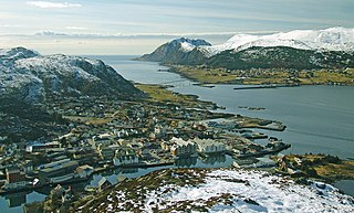
Fosnavåg (help·info) is a city in the municipality of Herøy in Møre og Romsdal county, Norway. It is the administrative center of the municipality of Herøy. The city is located on the island of Bergsøya, and it includes the Eggesbønes area on the south side of the island.

Austnes is a village in Haram Municipality in Møre og Romsdal county, Norway. It is located on the southeast side of the island of Haramsøya, about 12 kilometres (7.5 mi) southwest of the village of Longva via the Ullasund Bridge. The Ulla lighthouse is located about 7 kilometres (4.3 mi) to the north of Austnes. The historic Haram Church is located in Austnes.
Vatne is a village and former municipality in Haram Municipality in Møre og Romsdal county, Norway. The village of Vatne is located at the southern end of the Vatnefjorden in the eastern part of Haram Municipality. The 1.64-square-kilometre (0.63 sq mi) village has a population (2013) of 1,876 which gives it a population density of 1,144 inhabitants per square kilometre (2,960/sq mi). Other villages in the Vatne area include Eidsvik and Tennfjord to the south of the village of Vatne and Helle to the north of it.
Leitebakk is a small village on the island of Godøya in Giske Municipality in Møre og Romsdal county, Norway. The village is located about 4 kilometres (2.5 mi) southeast of the isolated village of Alnes, where Alnes Lighthouse is located. Leitebakk is located at the end of the undersea Godøy Tunnel that connects the island to the neighboring island of Giske. Godøy Chapel is located just south of the village of Leitebakk.

Alnes is a small village in Giske Municipality in Møre og Romsdal county, Norway. It is located on the (isolated) north side of the island of Godøya, about 4 kilometres (2.5 mi) northwest of the village of Leitebakk. The rest of the island's population is located on the southern half of the island, separated from Alnes by a large mountain. Alnes is accessible through a tunnel through the mountainous center part of the island.
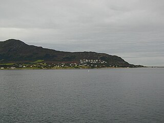
Brandal is a village in Hareid Municipality in Møre og Romsdal county, Norway. It is located on the eastern shores of the island of Hareidlandet, along the Sulafjorden. The village lies about 3.5 kilometres (2.2 mi) north of the municipal centre of Hareid and about 15 kilometres (9.3 mi) northeast of the town of Ulsteinvik on the other side of the island. The 0.3-square-kilometre (74-acre) village has a population (2013) of 346 people, giving the village a population density of 1,153 inhabitants per square kilometre (2,990/sq mi).
Haddal is a village in Ulstein Municipality in Møre og Romsdal county, Norway. The village is located on the western side of Hareidlandet island about 5 kilometres (3.1 mi) northwest of the village of Eiksund, about 4 kilometres (2.5 mi) southeast of the island of Dimnøya, and about 10 kilometres (6.2 mi) south of the town of Ulsteinvik.
Hoffland or Hovland is a village in Ålesund Municipality in Møre og Romsdal county, Norway. The village is located on the western end of the island of Ellingsøya, about 3 kilometres (1.9 mi) northeast of the town of Ålesund and about 5 kilometres (3.1 mi) west of the village of Myklebost.
Larsnes is the administrative centre of the municipality of Sande in Møre og Romsdal county, Norway. It is located on the southwest side of the island of Gurskøya, about 8 kilometres (5.0 mi) east of the island of Kvamsøya, 8 kilometres (5.0 mi) southwest of the village of Gursken, and about 25 kilometres (16 mi) southwest of the town of Ulsteinvik.

Sogndalsfjøra is the administrative center of the municipality of Sogndal in Sogn og Fjordane county, Norway. It is located where the river Sogndalselvi runs out in the Sogndalsfjorden, a branch of the large Sognefjorden. The village is located about 3.5 kilometres (2.2 mi) northwest of the village of Kjørnes, about 10 kilometres (6.2 mi) northwest of the village of Kaupanger, and about 31 kilometres (19 mi) southeast of the village of Fjærland.

Hardbakke is the administrative centre of the municipality of Solund in Sogn og Fjordane county, Norway. The village is located on the west side of the island of Sula, just across the strait from the island of Steinsundøyna. Hardbakke is located about halfway between the islet of Holmebåen and the village of Losnegard, the western- and eastern-most points in the municipality. The 0.26-square-kilometre (64-acre) village has a population (2013) of 295, giving the village a population density of 1,135 inhabitants per square kilometre (2,940/sq mi). Hardbakke has an elementary school and a secondary school, as well as Solund Church.

Vigra is a former municipality in Møre og Romsdal county on the west coast of Norway. It is located in the present-day Giske Municipality. The former municipality was made up of the island of Vigra along with many smaller islets surrounding it. The municipality existed from 1890 until 1964 when it was merged into Giske Municipality. The administrative centre of the municipality was the village of Roald, and Vigra Church was the main church for the municipality.

Valderøya is an island off the west coast of Norway. It is part of Giske Municipality in Møre og Romsdal county. The island is connected to the city of Ålesund to the south via the Valderøy Tunnel to the island of Ellingsøy and then by the Ellingsøy Tunnel to Ålesund. Valderøya is also connected to the island Vigra to the north by a short bridge. It is also connected to the island of Giske to the west by the Giske Bridge.

Raudeberg is a village in Vågsøy Municipality in Sogn og Fjordane county, Norway. It is located on the east side of the island of Vågsøy. The villages of Refvika, Vedvika, and Langeneset are located a few kilometers to the north, and the town of Måløy is about 6 kilometres (3.7 mi) to the south. The island of Silda is located about 2 kilometres (1.2 mi) northeast of the village of Raudeberg. Nord-Vågsøy Church is located on the eastern edge of the village, right along the coast.

Tjøtta is a village in Alstahaug Municipality in Nordland county, Norway. It is located on the southern tip of the island of Tjøtta, which is located south of the large island of Alsta. The village is located on an island, but it does have a mainland road connection via Norwegian County Road 17 and a series of bridges heading north to the town of Sandnessjøen. The historic Tjøtta Church is located in the village.

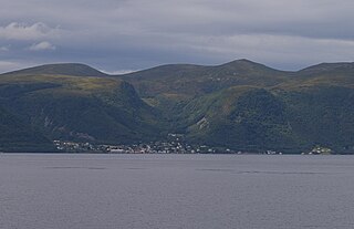
Vågsvåg is a village in Vågsøy Municipality in Sogn og Fjordane county, Norway. It is located on the southern shore of the island of Vågsøy along the Vågsfjorden, a part of the main Nordfjorden. The village looks across the fjord towards the island of Husevågøy.

Bryggja is a village in eastern part of Vågsøy Municipality in Sogn og Fjordane county, Norway. It is located on the mainland, along the northern shore of the Nordfjorden. The village is located about 15 kilometres (9.3 mi) east of the urban area of Måløy–Deknepollen–Tennebø in Vågsøy and it is about 25 kilometres (16 mi) west of Stårheim in neighboring Eid municipality. The small village of Totland lies just west of Bryggja.
Remøya is an island in the municipality of Herøy in Møre og Romsdal county, Norway. The island is located north of the municipal center of Fosnavåg. The island is connected to other islands via a network of bridges. The Remøy Bridge connects it to the island Leinøya and the Runde Bridge connects it to Runde. The highest point on the island is Vardan which is 191 metres (627 ft) above sea level. The island has an area of 3.6 square kilometres (1.4 sq mi).

Rensvik is a village in Kristiansund Municipality in Møre og Romsdal county, Norway. The village is located on the northern part of the island of Frei, just west of the Omsund Bridge which connects to the island of Nordlandet to the north. The 1.65-square-kilometre (410-acre) village has a population (2013) of 2,501; which gives the village a population density of 1,516 inhabitants per square kilometre (3,930/sq mi).

Namsskogan is the administrative centre of Namsskogan municipality in Trøndelag county, Norway. The village is located in the Namdalen valley on an island in the middle of the river Namsen, although it also includes land on both sides of the river. The European route E06 highway and the Nordlandsbanen railway line both run through the village, with the train stopping at Namsskogan Station. The village of Brekkvasselv lies about 12 kilometres (7.5 mi) to the south. Bjørhusdal Church is located about 4 kilometres (2.5 mi) west of the village.


