
Rajshahi Division is one of the eight first-level administrative divisions of Bangladesh. It has an area of 18,174.4 square kilometres (7,017.2 sq mi) and a population at the 2022 Census of 20,353,119. Rajshahi Division consists of 8 districts, 70 Upazilas and 1,092 Unions.

Cooch Behar district is a district of Indian state of West Bengal.

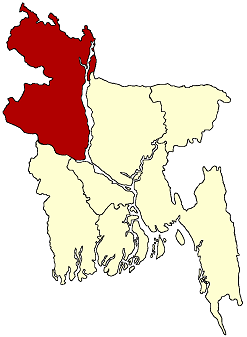
Joypurhat is a district in the northern part of Bangladesh, part of the Rajshahi Division.

Chapainawabganj is located in the north-western part of Bangladesh. It is a part of the Rajshahi Division, and was formerly a sub-division of Malda district. The north and west part of Chapai Nawabganj is bounded by Malda and Murshidabad districts of India, the east by Naogaon District, and south-east by Rajshahi District.

Jalpaiguri district is a district of the Indian state of West Bengal. The district was established in 1869 during British Raj.

The Geography of West Bengal, a state in eastern India, is primarily defined by plains and plateaus, with the high peaks of the Himalayas in the north and the Bay of Bengal to the south.

Malbazar, also known as Mal, is a town and a municipality in Jalpaiguri district in the state of West Bengal, India. It is the headquarters of the Malbazar subdivision. It lies about 65 km from Jalpaiguri and 55 km from Siliguri. It lies on the bank of river Neora.
North Bengal plains starts from the south of Terai region and continues up to the left bank of the Ganges. The southern parts of the district Jalpaiguri, North Dinajpur baring some extreme northern regions, South Dinajpur, Malda and Cooch Behar districts constitute this geographical region. The narrow land mass in the North Dinajpur district is known as Mahananda corridor. This corridor runs north to south joining Malda with the plains of Jalpaiguri, Alipurduar and Cooch Behar. The entire part of North and South Dinajpur is silt laden plain.

University of North Bengal is a public state collegiate major research university in North Bengal region of West Bengal, which is located in Raja Rammohanpur, Siliguri, Darjeeling district, in the Indian state of West Bengal. A second campus is in Danguajhar, Jalpaiguri in Jalpaiguri district and a third campus is in Salt Lake, Kolkata also in West Bengal. The university was established in 1962 to fill growing manpower needs in the six North Bengal districts and the neighbouring state of Sikkim. North Bengal University offers degrees in undergraduate, post-graduate taught-research, doctorate and post doctoral programs.

Eastern Bengal and Assam was an province of India between 1905 and 1912. Headquartered in the city of Dacca, it covered territories in what are now Bangladesh, Northeast India and Northern West Bengal.
Barind Tract is the largest Pleistocene era physiographic unit in the Bengal Basin. It covers most of Dinajpur, Rangpur, Pabna, Rajshahi, Bogra, and Joypurhat districts of Rajshahi Division and Rangpur Division in Bangladesh. It is made up of several separate sections in the northwestern part of Bangladesh covering a total area of approximately 10,000 square kilometres (3,900 sq mi) of mostly old alluvium. On the eastern edge of the tract is a lower fault escarpment. Through the fault troughs run the little Jamuna, Atrai and Lower Punarbhaba rivers. To the west, the main area is tilted up, and to the east this area is tilted downwards. The climate of the tract differs from that of much of India, in that more extreme temperature variations are encountered there. It is divided into three units: The Recent Alluvial Fan, the Barind Pleistocene, and the Recent Floodplain. These are divided by long, narrow bands of recent alluvium.
Varendra, also known as Barind, was a region of North Bengal, now mostly in Bangladesh and a little portion in the Indian state of West Bengal.

The Howrah–New Jalpaiguri line is a railway line connecting Howrah with New Jalpaiguri in North Bengal in the Indian state of West Bengal. The line continues through North Bengal and western part of Assam to connect with Guwahati. The Naihati–Bandel link allows trains from another terminus Sealdah in Calcutta to use this route. The line uses a major part of the Barharwa–Azimganj–Katwa loop. Many trains use an alternative line between Howrah and New Farakka, via Bardhaman and Rampurhat. Other parts of West Bengal and Bihar are well-connected to this line. It is under the administrative jurisdiction of Eastern Railway and Northeast Frontier Railway.

The New Jalpaiguri–Alipurduar–Samuktala Road line is a railway line that connects New Jalpaiguri- Siliguri Junction with Alipurduar and Samuktala Road in the Indian state of West Bengal. This railway line passes through the beautiful Doars region, which includes Mahananda Wildlife Sanctuary, Dooars-Terai tea gardens, Sevoke Railway Bridge, River Teesta, River Jaldhaka, River Torsha, Gorumara National Park, Buxa Tiger Reserve, Jaldapara National Park, Chapramari Wildlife Sanctuary, Chilapata Forests, Tunnels, Hills, Valleys etc.

The divisions of Bangladesh are divided into 64 districts or zila. The headquarters of a district is called a district seat. The districts are further subdivided into 495 subdistricts or upazilas.

The 12377 / 12378 Padatik Superfast Express is a daily Superfast train which runs between Sealdah in West Bengal and New Alipurduar in West Bengal via Barddhaman, Malda Town, New Jalpaiguri, Mathabhanga & New Cooch Behar in West Bengal.

The 13141 / 13142 Teesta Torsa Express is a daily non-superfast train in West Bengal, India which runs between Sealdah (SDAH) and New Alipurduar (NOQ) via Kalna, Katwa, Azimganj, Malda Town, New Jalpaiguri, Falakata & New Cooch Behar It passes through some important cities of West Bengal such as Berhampore, Malda, Siliguri, and Cooch Behar. It travels 718 km distance taking 17 hours with an average speed of 45 km/h.
The New Mal–Changrabandha–New Cooch Behar line are a set of 2 lines which connect Changrabandha, a border transit point near Indo-Bangladesh border in Cooch Behar district with the stations of New Mal in Jalpaiguri district and New Cooch Behar in Cooch Behar district of West Bengal. It is under the jurisdiction of Northeast Frontier Railway. The Malbazar–Changrabandha section of the line was a metre-gauge line, before its gauge conversion began on 2002. The Malbazar–Changrabandha section was re-opened to public on 20 January 2016 after gauge conversion. The New Changrabandha–New Cooch Behar broad-gauge line was built as an extension as a part of the New Maynaguri–Jogighopa rail line to provide an alternate link from North Bengal to Assam and was opened to public on 21 February 2016.
The 2022 Bidhannagar Municipal Corporation election was held on 12 February 2022 to elect 41 members of the Bidhannagar Municipal Corporation (BMC) which governs Bidhannagar, the Satellite city of the capital city of Indian state of West Bengal, Kolkata in the district of North 24 Parganas.


