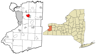
Depew is a village in Erie County, New York. The population was 15,303 at the time of the 2010 census. It is part of the Buffalo–Niagara Falls metropolitan area. The village is named for Chauncey Depew, a politician and one of the original investors who bought the land for the village, which was incorporated in 1894.

The city of Lancaster is the county seat of Lancaster County, South Carolina, United States, located in the Charlotte Metropolitan Area. As of the United States Census of 2010, the city population was 8,526. The city was named after the famous House of Lancaster.

A milestone is a numbered marker placed on a route such as a road, railway line, canal or boundary. They can indicate the distance to towns, cities, and other places or landmarks like mileage signs; or they can give their position on the route relative to some datum location. On roads they are typically located at the side or in a median or central reservation. They are alternatively known as mile markers, mileposts or mile posts. A "kilometric point" is a term used in metricated areas, where distances are commonly measured in kilometres instead of miles. "Distance marker" is a generic unit-agnostic term.
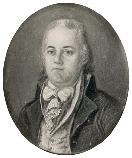
Andrew Ellicott was an American land surveyor who helped map many of the territories west of the Appalachians, surveyed the boundaries of the District of Columbia, continued and completed Pierre (Peter) Charles L'Enfant's work on the plan for Washington, D.C., and served as a teacher in survey methods for Meriwether Lewis.

Buildings, sites, districts, and objects in Virginia listed on the National Register of Historic Places:

This is a list of properties and districts listed on the National Register of Historic Places in Pennsylvania. As of 2015, there are over 3,000 listed sites in Pennsylvania. All 67 counties in Pennsylvania have listings on the National Register.

Salisbury National Cemetery is a United States National Cemetery located in the city of Salisbury, in Rowan County, North Carolina. It was established at the site of burials of Union soldiers who died during the American Civil War while held at a Confederate prisoner of war camp at the site.

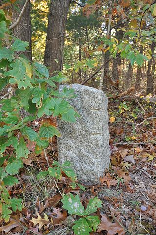
Ellicott’s Rock is a survey marker placed in 1811 by Andrew Ellicott as part of his survey to resolve the boundary dispute between the U.S. states of Georgia and North Carolina. The boundary dispute involved a brief armed conflict between the two called the Walton War, followed by an 1807 survey that Georgia refused to accept. Ellicott, hired by Georgia, undertook a new survey that confirmed the earlier line. He engraved a large rock in the Chattooga River with "N-G", standing for North Carolina - Georgia. The location had been prescribed in part in 1787 by the Treaty of Beaufort, though the river was not named explicitly, but rather as a then-undiscovered tributary of the Savannah River between Georgia and South Carolina. The nominal latitude of 35°N was later specified by the U.S. Congress.

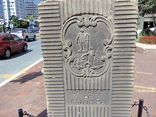
The boundary markers of the original District of Columbia are the 40 milestones that marked the four lines forming the boundaries between the states of Maryland and Virginia and the square of 100 square miles (259 km2) of federal territory that became the District of Columbia in 1801. Working under the supervision of three commissioners that President George Washington had appointed in 1790 in accordance with the federal Residence Act, a surveying team led by Major Andrew Ellicott placed these markers in 1791 and 1792. Among Ellicott's assistants were his brothers Joseph and Benjamin Ellicott, Isaac Roberdeau, George Fenwick, Isaac Briggs and an African American astronomer, Benjamin Banneker.

The 1767 Milestones are historic milestones located along the route of the Upper Boston Post Road between the cities of Boston and Springfield in Massachusetts. The 40 surviving milestones were added to the National Register of Historic Places in 1971. Massachusetts has a total of 129 surviving milestones including those along the upper Post Road. The stones are so named, despite having been placed in many different years, because of a 1767 directive of the Province of Massachusetts Bay that such stones be placed along major roadways. The state highway department was directed in 1960 to undertake their preservation. Many of them underwent a major restoration in 2018.

The Angle Tree Stone is a historic boundary marker astride the border of North Attleboro, Massachusetts and Plainville, Massachusetts.
The town of Barnstable, Massachusetts has four surviving stone markers that were used in colonial days to mark the town's boundaries with its neighbors. All four are listed on the National Register of Historic Places, three of them individually, and one as part of the Old King's Highway Historic District. Barnstable was established in 1639.

The 1872 California-Nevada State Boundary Marker marks the initial point for the 1872 survey delineation of the state line between California and Nevada. It is listed in the National Register of Historic Places.

Halifax County Courthouse is a historic county courthouse located at Halifax, Halifax County, North Carolina. It was designed by architects Wheeler & Stern and built in 1909–1910. It is a three-story, tan brick, Classical Revival style building. It has a tetrastyle Corinthian order portico flanked by two-story flat roofed wings and a two-stage cupola atop a shallow mansard roof.

The Milam County Courthouse and Jail are two separate historic county governmental buildings located diagonally opposite each other in Cameron, Milam County, Texas. The Milam County Courthouse, located at 100 South Fannin Avenue, was built in 1890–1892, while the Milam County Jail, now known as the Milam County Museum, was built in 1895. On December 20, 1977, they were added to the National Register of Historic Places as a single entry.
The Garden Club of America Entrance Markers in Washington, D.C., are carven stone pylons installed along the border of the District of Columbia in 1932 and 1933 by local Garden Club of America chapters. Originally about five feet tall, the markers were placed at important entrance points to the national capital. Seven survive: sets of two markers in Westmoreland Circle, Friendship Heights, and Chevy Chase Circle; and a single marker along Georgia Avenue. These surviving markers are listed on the National Register of Historic Places.

Abbeville, also known as Mt. Pleasant, is a historic home located at 1140 Columbia Avenue in Lancaster Township, Lancaster County, Pennsylvania.

Buford's Massacre Site, also known as Buford's Battleground, is a historic site and national historic district located near Lancaster, South Carolina. Two monuments at the site mark the battleground where the Battle of Waxhaws took place. A white monument ten feet tall, erected on June 2, 1860, marked the gravesite of American soldiers who died during the battle. This marker was gradually damaged over time by souvenir hunters who chipped off pieces, which led local authorities to erect a new monument on May 1, 1955, bearing the same inscription. The Battle of Waxhaws was a minor engagement during the American Revolutionary War between the Continental Army and Loyalist forces led by British colonel Banastre Tarleton, who became known as "Bloody Tarleton" as a result of accusations that his men massacred wounded American soldiers during the battle.

The Andrews-Duncan House is a historic building located at 407 North Blount Street in Raleigh, North Carolina, United States. Built in 1874 for a prominent businessman, the Italianate style home was designed by architect George S. H. Appleget. The house was added to the National Register of Historic Places (NRHP) in 1972 and is currently owned by the state government. A large tree named after a presidential candidate once stood behind the house and is commemorated with a historical marker.

The Grey Stone of Trough is an historic boundary marker in Bowland Forest High, in the Trough of Bowland, Lancashire, England. A Grade II listed structure, erected in 1897 and standing on Trough Road, it marks the line of the pre-1974 county boundary between Lancashire and the West Riding of Yorkshire. Historically, the Trough marked the westernmost boundary of the ancient Lordship of Bowland.


