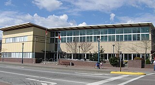
Last updated North Delta's "Social Heart" area includes the George Mackie Library opposite Nordel Shopping Centre.The new North Delta Public Safety Building on 84 Avenue serves as the HQ for North Delta's police and Fire and Emergency Services department.
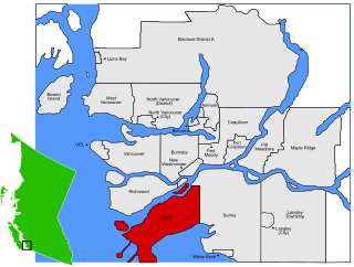
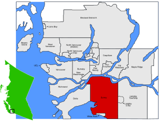
North Delta (founded as Annieville)[1] is a largely middle-class town and bedroom community situated in the Fraser Valley, of British Columbia, Canada. The community is the most populous of the three communities (North Delta, Ladner, and Tsawwassen) that make up the City of Delta. North Delta is home to numerous parks and recreational opportunities. Alongside North Delta is Burns Bog, the largest raised peat urban bog in North America. As well, Watershed Park provides walking and biking trails, home to many artesian aquifers. Besides this, North Delta is home to a large amount of green-space. As of the 2006 census, North Delta has a population of 51,623 which, according to the Settlement Hierarchy is a large town.
The Fraser Valley is the region of the Fraser River basin in southwestern British Columbia downstream of the Fraser Canyon. The term is sometimes used outside British Columbia to refer to the entire basin including the Fraser Canyon and up from there to its source, but in general British Columbian usage of the term refers to the stretch of the river downstream from the town of Hope, and includes all of the Canadian portion of the Fraser Lowland and areas flanking it.
British Columbia is the westernmost province of Canada, located between the Pacific Ocean and the Rocky Mountains. With an estimated population of 5.016 million as of 2018, it is Canada's third-most populous province.
Ladner is a part of the City of Delta, British Columbia, Canada, and a suburb of Vancouver, British Columbia. It was created as a fishing village on the banks of the Fraser River.
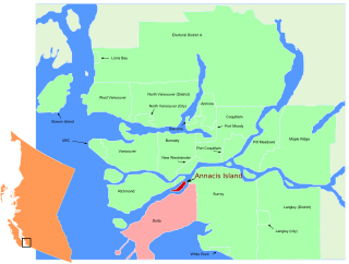
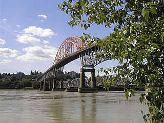
North Delta borders Surrey on the east side by Scott Road (or 120th Street), and on the north side by 96th Avenue and the Fraser River. To the west across the river is Annacis Island and Richmond, accessible via the Alex Fraser Bridge. Burns Bog is to the west, bordered by Highway 91. Clark Drive in Panorama Ridge marks the community boundary to the south.
Surrey is a city in the province of British Columbia, Canada, located south of the Fraser River and north of the Canada–United States border. It is a member municipality of the Metro Vancouver regional district and metropolitan area. Mainly a suburban city, Surrey is the province's second-largest by population after Vancouver and the third largest by area after Abbotsford and Prince George.
The Fraser River is the longest river within British Columbia, Canada, rising at Fraser Pass near Blackrock Mountain in the Rocky Mountains and flowing for 1,375 kilometres (854 mi), into the Strait of Georgia at the city of Vancouver. It is the 11th longest river in Canada. The river's annual discharge at its mouth is 112 cubic kilometres (27 cu mi) or 3,550 cubic metres per second (125,000 cu ft/s), and it discharges 20 million tons of sediment into the ocean.
Annacis Island is an island located in the south arm of the Fraser River, in Delta, British Columbia. The island is now mostly industrial, and it contains one of Metro Vancouver's secondary wastewater treatment plants.
Transportation
North Delta is mostly divided up into a grid with streets running north/south and east/west. Running east/west are the avenues, they are numbered with increasing numbers when traveling north, and vice versa. Running north/south, the streets are numbered following the grid laid out for the municipality of Delta. This grid is part of the greater street grid set out by the British Royal Engineers in the 19th Century. Lower numbers are nearest the Pacific Ocean, and the street numbering continues up through the 200s in Langley.
The Corps of Royal Engineers, usually just called the Royal Engineers (RE), and commonly known as the Sappers, is one of the corps of the British Army.
The Township of Langley is a district municipality immediately east of the City of Surrey in southwestern British Columbia, Canada. It extends south from the Fraser River to the U.S. border, and west of the City of Abbotsford. Langley Township is not to be confused with the City of Langley, which is adjacent to the township but politically is a separate entity. Langley is located in the eastern part of Metro Vancouver.
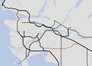
Some of the main arterial roads in North Delta are River Road, Nordel Way, and 120th Street (Scott Road).
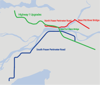
Before the construction of the South Fraser Perimeter Road, River Road ran along the shore of the Fraser River. It starts in Surrey, and travels through the industrial zones of North Delta and the residential community of Annieville before junctioning the Nordel Way, where a driver can access Highway 91. No longer part of North Delta, River Road continues north of Burns Bog and terminates at Highway 99, where it becomes Highway 17A. The South Fraser Perimeter Road, part of Highway 17, is a freeway that opened in 2013, running closer to the shore than River Road for the entirety of its North Delta portion.
Highway 99, also known as the Fraser Delta Thruway south of Vancouver, and the Sea to Sky Highway, the Squamish Highway, or Whistler Highway north of Vancouver, is the major north–south artery running through the Greater Vancouver area of British Columbia from the U.S. border, up Howe Sound through the Sea to Sky Country to Lillooet, and connecting to Highway 97 just north of Cache Creek. The number of this highway is derived from the old U.S. Route 99, with which the highway originally connected. The highway currently connects with Interstate 5 at the international border.
Highway 17A is a 6 km (3.7 mi) long route connecting Highway 99 and Highway 17; this route was originally numbered Highway 17 between these two points but once the South Fraser Perimeter Road neared completion, the numbering was altered.
Nordel Way is a high speed corridor that runs from River Road to Surrey, where it merges with 88th Avenue. It is mostly used by drivers commuting from the northern parts of North Delta and Surrey to Highway 91 and back. Until the late 1990s, Nordel Way terminated at 116th Street, but it was extended into Surrey.
120th Street, or Scott Road, is the street that divides Delta and Surrey to the east. Many businesses and shopping areas are along this street. The street travels into Surrey beyond 96th Avenue and joins with King George Highway, where one can cross the Pattullo Bridge into New Westminster.
The Pattullo Bridge is a through arch bridge that crosses the Fraser River and links the city of New Westminster to the city of Surrey in British Columbia. The bridge was named in honour of Thomas Dufferin Pattullo, the 22nd Premier of British Columbia. A key link between Surrey and the rest of Greater Vancouver, the Pattullo Bridge handles an average of 75,700 cars and 3840 trucks daily, or roughly 20 percent of vehicle traffic across the Fraser River as of 2013.
New Westminster is a city in the Lower Mainland region of British Columbia, Canada, and a member municipality of Metro Vancouver. It was founded by Major-General Richard Moody as the capital of the new-born Colony of British Columbia in 1858, and continued in that role until the Mainland and Island Colonies were merged in 1866, and was the Mainland's largest city from that year until it was passed in population by Vancouver during the first decade of the 20th Century.
72nd Avenue, 64th Avenue, and 56th Avenue (Highway 10) are also major connectors, having access from Highway 91 into Surrey.
Highway 10 is a minor east-west route through the southern portion of Greater Vancouver. Highway 10 is used mainly as a local access route in North Delta, Surrey and Langley, its former connector role between South Delta and Highway 1 having been taken over by the Highway 17.
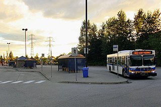
There is no major transit exchange in North Delta. However, before the 2000s, the Scottsdale Exchange was located in North Delta by Scott Road before it was moved to the other side of the border, within walking distance. The bus routes provide residents of North Delta connections to nearby SkyTrain stations such as Scott Road Station and 22nd Street Station, among other destinations.
Neighbourhoods and communities
Annieville– original settlement and location of the first commercial salmon cannery in BC in 1870[2]
North Delta has five high schools: North Delta Senior Secondary, Seaquam Secondary, Sands Secondary, Burnsview, and Delview. Prior to the 2004–2005 school year, Sands, Burnsview, and Delview were Junior Secondary schools, offering only grades 8 to 10. Graduates from these three schools fed into North Delta Senior Secondary, which offered only a grade 11 and 12 curriculum; Seaquam Secondary was the only complete grade 8 to 12 secondary school in North Delta. North Delta Senior Secondary typically had one of the largest graduating classes in British Columbia. Despite the controversy surrounding the reconfiguration, in the academic year 2004 - 2005 the three Junior Secondary schools were reconfigured to include grade 11 and 12 classes, while North Delta Senior Secondary was expanded to include junior level courses.
North Delta is home to three recreational complexes: the recently renovated Sungod Recreation Centre, which houses both a swimming pool and an indoor ice rink; the Great Pacific Forum ice arena at the base of the Alex Fraser Bridge; and North Delta's oldest sports complex, the North Delta Recreational Centre, which consists of an ice rink, 6 curling sheets, and an outdoor pool. Lying adjacent to the North Delta Recreational Centre is a small kids' camp, a large softball park, and skateboard park.
Krispy Kreme Doughnuts, Inc. is an American doughnut company and coffeehouse chain founded in Winston-Salem, North Carolina. Krispy Kreme founder Vernon Rudolph bought a yeast-raised recipe from a New Orleans chef and, in 1937, rented a building in what is now historic Old Salem in Winston-Salem, North Carolina, and began selling to local grocery stores. Steady growth preceded an ambitious expansion as a public company in the period 2000-2016, which ultimately proved unprofitable. In 2016, the company returned to private ownership under JAB Holding Company, a private Luxembourg-based firm.
Delta is a small city in British Columbia, and forms part of Greater Vancouver. Located south of Richmond, it is bordered by the Fraser River to the north, the United States to the south and the city of Surrey to the east. Delta is composed of three distinct communities: Ladner, Tsawwassen, and North Delta.
Pitt Meadows is a city in southwestern British Columbia, Canada and a member municipality in Metro Vancouver. Incorporated in 1914, it has a land area of 85.38 square kilometres and a population of 18,573.
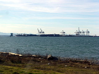
Tsawwassen is a suburban, mostly residential community located on a peninsula in the southwestern corner of the City of Delta in British Columbia, Canada. Tsawwassen provides the only road access to the community of Point Roberts, Washington via 56th Street. It is also the location of Tsawwassen Ferry Terminal, part of the BC Ferries, built in 1959 to provide foot-passenger and motor vehicle access from the Lower Mainland to the southern part of Vancouver Island and the Southern Gulf Islands. Because Tsawwassen touches a shallow bank, the ferry terminal is built at the southwestern end of a 3 km (1.9 mi) long causeway that juts out into the Strait of Georgia. The ferry dock and causeway are part of Highway 17. Boundary Bay Airport, a major training hub for local and international pilots which also provides local airplane and helicopter service, is located ten minutes away. The Roberts Bank Superport is also located near Tsawwassen.
The City of Langley is a municipality in the Metro Vancouver Regional District. It lies directly east of the City of Surrey, adjacent to the Cloverdale area, and surrounded on the north, east and south by the Township of Langley.
Surrey North was a federal electoral district in British Columbia, Canada, that was represented in the House of Commons of Canada from 1988 to 2015. It covered the northern part of Surrey.
Killarney is a neighbourhood in East Vancouver, British Columbia with a population of over 28,000 in 2011 and lies in the far southeast corner of the city. It is on the south slope of the ridge that rises above the Fraser River, and contains a collection of single-family residences with a few multi-family homes as well as the townhouses and high-rises of the Fraserlands development along the river.
Sands Secondary is a public high school in Delta, British Columbia part of School District 37 Delta.
North Delta Secondary is a public high school in Delta, British Columbia, Canada. It is part of School District 37 Delta.
The Gateway Program is a C$3.0 billion regional transportation project for Metro Vancouver that is being managed by the British Columbia Ministry of Transportation. The ministry introduced the Gateway Program on January 31, 2006, as a means to address growing congestion and reduce travel times.
Sunnyside is a neighbourhood of South Surrey, which in turn is a region of Surrey, British Columbia, Canada.
The 400-series highways were a pair of controlled-access highways located in the southwestern portion of the Canadian province of British Columbia, forming a special subset of the provincial highway system. Modelled after the 400-Series Highways in Ontario, 400-series designations were introduced in 1964 in conjunction with the completion of the Trans-Canada Highway freeway between Vancouver and Clearbrook ; however, unlike their Ontario counterparts, both routes had signalized sections. The 400-series system never expanded beyond two freeways, and in 1973 Highways 401 and 499 were renumbered 1 and 99 respectively, while the former routes were assigned the 'A' suffix.
Scottsdale Exchange is a major transit exchange located in the Strawberry Hill neighbourhood of Newton in Surrey, British Columbia. Opened on May 30, 1975, it is home to bus routes serving the South of Fraser region including the municipalities of Delta and Langley, as well as Richmond. It is a terminus for most of these routes, which provide connections to SkyTrain stations in Surrey and Richmond.
The British Columbia electoral redistribution of 2015 was a process undertaken by the BC Electoral Boundaries Commission starting in 2014 and formalized by the passing of Bill 42 - 2015 Electoral Districts Act during the 40th Parliament. The redistribution added two seats onto the previous total, raising the number of MLAs from 85 to 87. The electoral boundaries came into effect for the 2017 election.
This page is based on this Wikipedia article Text is available under the CC BY-SA 4.0 license; additional terms may apply. Images, videos and audio are available under their respective licenses.