Northcote, Christchurch

Last updated

Northcote
Northcote, Christchurch
Coordinates: 43°29′17″S172°36′58″E / 43.488°S 172.616°E / -43.488; 172.616 Coordinates: 43°29′17″S172°36′58″E / 43.488°S 172.616°E / -43.488; 172.616
Country New Zealand
City Christchurch
Local authority Christchurch City Council
Electoral wardPapanui
Area
[1]
  Land168 ha (415 acres)
Population
 (June 2021) [2]
  Total2,770
Casebrook Redwood Marshland
Pfeil oben.svg
Pfeil links.svgNorthcotePfeil rechts.svg
Pfeil unten.svg
Mairehau
Papanui St Albans

Northcote is a suburb on the northern side of Christchurch, New Zealand.

Contents

Etymology

The suburb is named for the British politician, Stafford Northcote (1818–1887). [3]

Demographics

Northcote covers 1.68 km2 (0.65 sq mi). [1] It had an estimated population of 2,770 as of June 2021, [2] with a population density of 274 people per km2.

Historical population
YearPop.±% p.a.
20062,547    
20132,526−0.12%
20182,622+0.75%
Source: [4]

Northcote had a population of 2,622 at the 2018 New Zealand census, an increase of 96 people (3.8%) since the 2013 census, and an increase of 75 people (2.9%) since the 2006 census. There were 1,014 households. There were 1,278 males and 1,344 females, giving a sex ratio of 0.95 males per female. The median age was 39.6 years (compared with 37.4 years nationally), with 435 people (16.6%) aged under 15 years, 504 (19.2%) aged 15 to 29, 1,233 (47.0%) aged 30 to 64, and 453 (17.3%) aged 65 or older.

Ethnicities were 72.3% European/Pākehā, 9.3% Māori, 2.3% Pacific peoples, 20.4% Asian, and 3.8% other ethnicities (totals add to more than 100% since people could identify with multiple ethnicities).

The proportion of people born overseas was 30.2%, compared with 27.1% nationally.

Although some people objected to giving their religion, 45.4% had no religion, 43.1% were Christian, 1.9% were Hindu, 0.5% were Muslim, 0.7% were Buddhist and 2.6% had other religions.

Of those at least 15 years old, 420 (19.2%) people had a bachelor or higher degree, and 429 (19.6%) people had no formal qualifications. The median income was $32,100, compared with $31,800 nationally. The employment status of those at least 15 was that 1,122 (51.3%) people were employed full-time, 300 (13.7%) were part-time, and 102 (4.7%) were unemployed. [4]

Related Research Articles

Waltham, New Zealand Suburb of Christchurch in Christchurch City Council, New Zealand

Waltham is an inner suburb of Christchurch, New Zealand, located approximately two kilometres south-east of the city centre. State Highway 76, part of Christchurch's ring road system, and known there as Brougham Street, runs through the suburb, as does the Lyttelton Line rail corridor.

Addington, New Zealand Suburb of Christchurch in Christchurch City Council, New Zealand

Addington is a major suburb of Christchurch, New Zealand. It is sited 2.5 kilometres (1.6 mi) south-west of the city centre.

Hornby, New Zealand Suburb of Christchurch in Christchurch City Council, New Zealand

Hornby is a major residential and retail suburb at the western edge of Christchurch, New Zealand. The suburb is directly connected to other parts of Christchurch and the South Island by a number of main arterial routes, including State Highway 1 and the Christchurch Southern Motorway.

Redwood, Christchurch Suburb of Christchurch in Christchurch City Council, New Zealand

Redwood is a suburb located in Christchurch, New Zealand which includes the sub-division of Redwood Springs. The suburb was first named Styx but renamed following a popular vote of local residents in the 1960s after a large Sequoia redwood tree still standing in Prestons Road. The original forest cover was Totara and Kahikatea. Redwood has its own community radio station called Good Music FM 107.5.

Strowan Suburb of Christchurch in Christchurch City Council, New Zealand

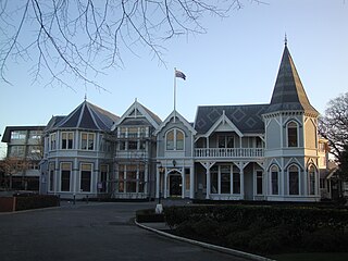
Strowan is an affluent suburb of Christchurch, New Zealand, located approximately 5 km north-west of Christchurch's central business district. It had a population of 3,705 at the 2013 census. It is located between the suburbs of Merivale, Papanui, Bryndwr, Fendalton, and St Albans.

Avondale, Christchurch Suburb of Christchurch in Christchurch City Council, New Zealand

Avondale is a suburb of Christchurch in the South Island of New Zealand. It is located 6 kilometres (3.7 mi) northeast of the city center, and is close to the Avon River, four kilometers to the northwest of its estuary. The suburb is centered on Avondale Road and so named due to its proximity to the Avon River. It has a good sized park on Mervyn Drive called Avondale Park. This park has a kids playground, a tennis court, basketball court, and a football field in winter. There is ample vacant red zone land in Avondale for activities such as leisure and dog walking.

Mount Pleasant, New Zealand Suburb of Christchurch in Christchurch City Council, New Zealand

Mount Pleasant (Tauhinukorokio) is a coastal suburb of Christchurch, New Zealand. The suburb is located on the northern flank of the mountain Tauhinukorokio/Mount Pleasant in the Port Hills. It takes its name from the English version of the mountain's name.

Harewood, New Zealand Suburb of Christchurch in Christchurch City Council, New Zealand

Harewood is a northwestern suburb of Christchurch, New Zealand. The suburb is split by State Highway 1, with the bulk of Harewood's residential areas to the east of the highway and its industrial areas to the west.

Phillipstown, New Zealand Suburb of Christchurch, New Zealand

Phillipstown is a small inner suburb of the city of Christchurch, New Zealand. It lies south-east of the city centre being bordered by Cashel Street to the north, Aldwins Road to the east, Ferry Road to the south, and Fitzgerald Avenue to the west.

South New Brighton Suburb of Christchurch in Christchurch City Council, New Zealand

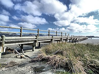
South New Brighton is a coastal suburb on the eastern side of Christchurch city.

Bottle Lake, New Zealand Suburb of Christchurch in Christchurch City Council, New Zealand

Bottle Lake is a suburb in the north-east of Christchurch with a low number of residents. Most of the suburb is covered by Bottle Lake Forest, which has since the mid-1970s become a popular recreation area.

Hillsborough, Christchurch Suburb of Christchurch in Christchurch City Council, New Zealand

Hillsborough is a mixed industrial and residential suburb of Christchurch, New Zealand, located approximately 4 kilometres (2.5 mi) to the south-east of the city centre.

Waimairi Beach Suburb of Christchurch in Christchurch City Council, New Zealand

Waimairi Beach is a suburb of Christchurch, New Zealand. It is located north east of the city. It is east of Parklands and north of North New Brighton. The word "waimairi" translates to "listless stream".

Bromley, New Zealand Suburb of Christchurch in Christchurch City Council, New Zealand

Bromley is a suburb of the city of Christchurch, New Zealand. It lies to the east of the city centre, mostly between Pages Road and the Avon river estuary.

Middleton is a predominantly industrial and wholesale suburb of Christchurch, New Zealand. It is located in the west of the city, between Wigram and Addington, and immediately to the south of Upper Riccarton.

Russley is a suburb on the western side of Christchurch city.

Islington is a suburb on the western side of Christchurch city.

Marshland, New Zealand Suburb of Christchurch in Christchurch City Council, New Zealand

Marshland is a semi-rural suburb on the northern side of Christchurch city. The land is primarily used for horticulture and dairy farming.

Broomfield is a suburb on the western side of Christchurch city.

Prestons is a suburb on the northeastern side of Christchurch city.

References

  1. 1 2 "ArcGIS Web Application". statsnz.maps.arcgis.com. Retrieved 16 September 2021.
  2. 1 2 "Population estimate tables - NZ.Stat". Statistics New Zealand . Retrieved 22 October 2021.
  3. "Christchurch Place Names: N – Z : Northcote" (PDF). Christchurch City Libraries. February 2016. p. 7.
  4. 1 2 "Statistical area 1 dataset for 2018 Census". Statistics New Zealand. March 2020. Northcote (Christchurch City) (320500). 2018 Census place summary: Northcote (Christchurch City)