
A cable-stayed bridge has one or more towers, from which cables support the bridge deck. A distinctive feature are the cables or stays, which run directly from the tower to the deck, normally forming a fan-like pattern or a series of parallel lines. This is in contrast to the modern suspension bridge, where the cables supporting the deck are suspended vertically from the main cable, anchored at both ends of the bridge and running between the towers. The cable-stayed bridge is optimal for spans longer than cantilever bridges and shorter than suspension bridges. This is the range within which cantilever bridges would rapidly grow heavier, and suspension bridge cabling would be more costly.
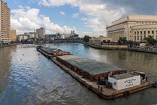
The Pasig River is a water body in the Philippines that connects Laguna de Bay to Manila Bay. Stretching for 25.2 kilometers (15.7 mi), it bisects the Philippine capital of Manila and its surrounding urban area into northern and southern halves. Its major tributaries are the Marikina River and San Juan River. The total drainage basin of the Pasig River, including the basin of Laguna de Bay, covers 4,678 square kilometers (1,806 sq mi).

Pasig, officially the City of Pasig, is a highly urbanized city in the National Capital Region of the Philippines. According to the 2020 census, it has a population of 803,159 people.
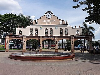
Marikina, officially the City of Marikina, is a 1st class highly urbanized city in the National Capital Region of the Philippines. According to the 2020 census, it has a population of 456,159 people.

Antipolo, officially the City of Antipolo, is a 1st class component city and capital of the province of Rizal, Philippines. According to the 2020 census, it has a population of 887,399 people. It is the most populous city in the Calabarzon region, and the seventh most-populous city in the Philippines.

An extradosed bridge employs a structure that combines the main elements of both a prestressed box girder bridge and a cable-stayed bridge. The name comes from the word extrados, the exterior or upper curve of an arch, and refers to how the "stay cables" on an extradosed bridge are not considered as such in the design, but are instead treated as external prestressing tendons deviating upward from the deck. In this concept, they remain part of the main bridge superstructure.

The Metro Manila Skyway, officially the Metro Manila Skyway System (MMSS) or simply the Skyway, is an elevated highway which is the main expressway in Metro Manila, Philippines. It connects the North and South Luzon Expressways with access to Ninoy Aquino International Airport via the NAIA Expressway (NAIAX). It is the first fully grade-separated highway in the Philippines and one of the longest elevated highways in the world, with a total length of approximately 39.2 kilometers (24.4 mi).
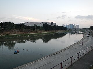
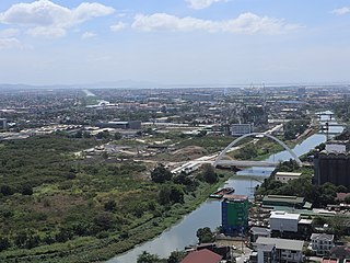
The Marikina River is a river in eastern Metro Manila, Philippines. It is the largest tributary of the Pasig River, with headwaters located in the Sierra Madre Mountains in Rodriguez, Rizal province.

Circumferential Road 5 (C-5), informally known as the C-5 Road, is a network of roads and bridges that all together form the fifth beltway of Metro Manila in the Philippines. Spanning some 42.3 kilometers (26.3 mi), it connects the cities of Las Piñas, Makati, Parañaque, Pasay, Pasig, Quezon City, Taguig, and Valenzuela.

Circumferential Road 3 (C-3), informally known as the C-3 Road, is a network of roads and bridges that all together form the third beltway of Metro Manila in the Philippines. Spanning some 32.5 kilometers (20.2 mi), it connects the cities of Caloocan, Makati, Navotas, Pasay, Quezon City, and San Juan.

The Pasig River is a river in the Philippines running right through the heart of Manila. It flows from Laguna de Bay to Manila Bay through a length of 26 kilometers (16 mi) and an average of 50 meters (160 ft) in width. The average depth of the river in around 4–6 meters (13–20 ft). The river runs through some of the most populated areas in the Philippines.
The Pasig River Expressway (PAREX) is a proposed elevated expressway in Metro Manila, Philippines that will skirt the banks of the Pasig River and connect the cities of Manila, Mandaluyong, Makati, Pasig, Taguig and the municipality of Taytay. The expressway is being proposed to alleviate east-west traffic congestion in Metro Manila. It is a joint venture between the Philippine National Construction Corporation and the San Miguel Corporation. The project broke ground on September 24, 2021, while construction of the expressway has yet to start pending the approval of its Environmental Compliance Certificate (ECC).

Julia Vargas Avenue is a central east–west arterial road that passes through Ortigas Center in Metro Manila, Philippines. It is a four-lane divided road with one-way protected bike lanes that runs parallel to Ortigas Avenue to the north and Shaw Boulevard to the south. The avenue stretches 2.3 kilometers (1.4 mi) from Eulogio Rodriguez Jr. Avenue in Ugong, Pasig in the east to Epifanio de los Santos Avenue (EDSA) in Wack-Wack Greenhills, Mandaluyong in the west.

Meralco Avenue is a north-south thoroughfare located in Ortigas Center in Pasig, Metro Manila, Philippines. It links Ortigas Avenue in the north and Shaw Boulevard in the south and borders the western edge of Valle Verde in Ugong. It is named for the Manila Electric Company, also known as Meralco, which is headquartered on the avenue's junction with Ortigas Avenue. Other notable businesses on Meralco Avenue include UnionBank Plaza, Marco Polo Ortigas Manila, Ayala Malls The 30th, Metrowalk, and the mixed-use development called Capitol Commons at the former Rizal Provincial Capitol lot on Meralco and Shaw Boulevard.

Mel Lopez Boulevard is a 6.2-kilometer (3.9 mi), six-to-ten lane divided highway in northern Manila, Philippines, connecting Bonifacio Drive in Port Area in the south with Radial Road 10 (R-10) in Navotas in the north. The highway is the main component of the R-10 network, which runs north of the Pasig River, and is an extension of Bonifacio Drive north of the Anda Circle, running north–south through the Manila North Port area serving the coastal districts of Tondo and Port Area, as well as San Nicolas and Intramuros.
Expressway 5 (E5) forms part of the Philippine expressway network. Collectively known as the North Luzon Expressway Harbor Link Project, it runs from Congressional Avenue and Luzon Avenue, both components of Circumferential Road 5, in Quezon City to Radial Road 10 in Navotas, linking the North Luzon Expressway to the Port of Manila. Currently, its segment from Mindanao Avenue in Valenzuela to Navotas is operational.

Circulo Verde is a mixed-use development in Quezon City, Metro Manila, the Philippines. It is a primarily residential enclave on a meander of the Marikina River in the village of Bagumbayan on Quezon City's border with Pasig. The 12.47-hectare (30.8-acre) riverfront community is a redevelopment of the former cement plant owned by Concrete Aggregates Corp., a subsidiary of Ortigas & Company. It is one of the four major estates owned and developed by the company in Metro Manila, which in 2019 maintained a combined land bank of 50 hectares across the Eastern Manila cities of Mandaluyong, Pasig and Quezon City.

Arcovia City is a mixed-use development in Ugong, Pasig, Metro Manila, the Philippines. It is a 12.3-hectare (30-acre) riverside township located by the Marikina River east of Ortigas Center being developed by the Megaworld Corporation.
Parklinks is a 35-hectare (86-acre) mixed-use development that straddles the Pasig–Quezon City boundaries in the Philippines. It is a joint project of LT Group and Ayala Land located on the banks of the Marikina River in the eastern part of Metro Manila. The riverfront development is the biggest along the segment of C-5 Road north of the Pasig River and is planned to contain a 3-hectare (7.4-acre) central urban park, an esplanade, river terrace, riparian gardens and bike trails designed to make it one of the greenest urban estates in the Manila metropolitan area.

The Makati–Mandaluyong Bridge is a four-lane road bridge crossing the Pasig River in Metro Manila, the Philippines. It connects P. Burgos Extension, a continuation of Makati Avenue in Barangay Poblacion, Makati at the south bank of the river to Coronado Street in Barangay Hulo, Mandaluyong at the north bank. The bridge was opened in 1986.
