Notwane River

Last updated
Notwane River
Gaborone Dam 1.jpg
View of Gaborone Dam in the Notwane River
South Africa relief location map.svg
Red pog.svg
Location of the Notwane River mouth
Location
Country Botswana
Physical characteristics
Source Kalahari
Mouth Pala Camp
  location
Limpopo River, South Africa/Botswana border
  coordinates
23°44′56″S26°57′37″E / 23.74889°S 26.96028°E / -23.74889; 26.96028 Coordinates: 23°44′56″S26°57′37″E / 23.74889°S 26.96028°E / -23.74889; 26.96028
  elevation
847 m (2,779 ft)
Basin size18,053 km2 (6,970 sq mi)

The Notwane River (or Ngotwane River) is a river in southeastern Botswana. Certain sections of its course form the international boundary with South Africa. Its mouth is at the head of the Limpopo River. It has a catchment area of 18,053 square kilometers.

Contents

Course

Train crossing bridge over Notwane River Blue Train in Notwane Bridge.jpg
Train crossing bridge over Notwane River

The Notwane rises about 11 kilometres (6.8 mi) south of Ramotswa, and runs along the border in a northeast direction to enter the Limpopo at the same longitude as Mahalapye. [1] The Notwane has its source in the sandveld, at the eastern fringes of the Kalahari Desert. It flows roughly northeastwards past the most densely populated area of Botswana, passing east of Lobatse, between the city of Gaborone and Tlokweng village and then through Mochudi village. Finally it joins the left bank of the Limpopo River at the border with South Africa, just 6 km short of the confluence of the Limpopo with the Matlabas River. [2]

The Notwane basin is drained by the Notwane itself and its tributaries the Taung, Segoditshane, Metsimotlhabe, Metsemaswaane and Nywane. [1] Its main tributaries are the Taung, Peleng, Metsimotlhabe and Nywane rivers. All the rivers in the Notwane basin are ephemeral experiencing mostly brief, seasonal flow depending from the rainfall. The Notwane and Taung riverbeds are dry during the dry season and in years of drought they may be completely dry the whole year round. All these rivers may cause flash floods. [3]

History

The banks of the Notwane River have been occupied since the middle Stone Age. The first modern settlement was Moshaweng, which was established by Chief Gaborone of the Tlokwa in the late 1880s, near the site of the modern capital. [4] The city of Gaborone, an expansion of the earlier settlement, was developed on the Notwane River in the 1960s in part due to proximity to the railway, in part due to availability of water provided by the river. [5]

Dams

NASA picture of the Notwane River with the Gaborone Dam Gaborone 25.92305E 24.68895S.jpg
NASA picture of the Notwane River with the Gaborone Dam

The Gaborone Dam, which supplies water to the city of Gaborone, has a capacity of 144,000,000 cubic metres (5.1×10⁹ cu ft). Further upstream, the Ngotwane Dam in Lehurutshe, South Africa has a capacity of 18,000,000 cubic metres (640,000,000 cu ft). In the Gaborone dam catchment area there are many other dams, mostly very small, with only the Nnywane Dam near Lobatse being used for domestic water supply. Following a 1992 study on their impact on downstream water resources, a moratorium was placed on construction of small dams in the catchment area. [6]

Fauna and Flora

Whilst the flow of the Notwane is ephemeral; biodiversity is the highest immediately upstream of the Gaborone Dam, north of the confluence with the Taung river. The riverbed in this area generally retains small pools of water, even during prolonged dry periods.

The African sharptooth catfish, locally known as barbel, are the most common fish species in these waters. The river also supports smaller populations of bream, tilapia and introduced carp.

Birdlife proliferates as one gets nearer to the Gaborone Dam, this includes a number of heron and kingfisher species. African fish eagle are seen regularly, along with reed cormorant and african darter. Verreaux's eagle-owl do occur in the area and yellow-billed kite are common summer visitors. Southern yellow-billed hornbill, southern red-billed hornbill and natal spurfowl are often seen in the surrounding woodland.

Vervet monkey are common along the river course nearer the Gaborone Dam. Chacma baboon may also be encountered and antelope species such as kudu and impala are present, but rare. Lesser bushbaby nest in this area and black-backed jackal are heard occasionally in the evening. A small population of nile crocodile are resident in the lower courses of the river close to the Gaborone Dam. Both nile monitor and rock monitor do occur in the area, the former being seen more regularly. The riparian vegetation and surrounding woodland also provides suitable habitat for African rock python and mozambique spitting cobra.

The river course is dominated by syringa berrytree, water fig and white bauhinia. The syringa berrytree being an invasive species introduced from India. The riparian vegetation eventually gives way to acacia woodland. Buffalo thorn, paperback thorn and knobthorn are common to this woodland. Marula and weeping wattle also occur in the area.

See also

Related Research Articles

Transport in Botswana Transport in Botswana

Transportation in Botswana is provided by internal and extensive network of railways, highways, ferry services and air routes that criss-cross the country.

Limpopo River River in southern Africa

The Limpopo River rises in South Africa, and flows generally eastwards through Mozambique to the Indian Ocean. The term Limpopo is derived from Rivombo (Livombo/Lebombo), a group of Tsonga settlers led by Hosi Rivombo who settled in the mountainous vicinity and named the area after their leader. The river is approximately 1,750 kilometres (1,087 mi) long, with a drainage basin 415,000 square kilometres (160,200 sq mi) in size. The mean discharge measured over a year is 170 m3/s at its mouth. The Limpopo is the second largest river in Africa that drains to the Indian Ocean, after the Zambezi River.

Gaborone Capital of Botswana

Gaborone is the capital and largest city of Botswana with a population of 231,626 based on the 2011 census, about 10% of the total population of Botswana. Its agglomeration is home to 421,907 inhabitants at the 2011 census.

Botswana Railways

Botswana Railways (BR) is the national railway of Botswana.

Shashe River

The Shashe River is a major left-bank tributary of the Limpopo River in Zimbabwe. It rises northwest of Francistown, Botswana and flows into the Limpopo River where Botswana, Zimbabwe and South Africa meet. The confluence is at the site of the Greater Mapungubwe Transfrontier Conservation Area.

Crocodile (West) and Marico WMA, or Crocodile (West) and Marico Water Management Area , in South Africa is sub-divided into 6 sub-management areas each corresponding with a (part) river drainage area, and include the following major rivers: the Crocodile River and Marico River, sub divided into an upper Crocodile River sub-management area and a lower Crocodile River sub-management area. The Marico River sub-management area, the upper Molopo River sub-management area, The Elands River sub-management area, and the Apies River / Pienaars River sub-management area.

Marico River

The Marico River or Madikwe is a river in Southern Africa. There are a number of dams in its basin. Groot Marico town is named after the Marico River. After it is joined on its right bank by the Crocodile River it is known as the Limpopo River.

Drainage Basin A, is one of the drainage basins of South Africa. The main river in this system is the Limpopo River. It is subdivided into 9 sub-drainage basins.

The history of Gaborone began with archaeological evidence in the area around Gaborone dating back to 400 BCE, and the first written accounts of Gaborone are from the earliest European settlers in the 19th century. Since the 1960s, when Botswana gained its independence from Britain and Gaborone became the capital, the city has grown from a small village in the Botswana scrubland to a major center in southern Africa.

Mogalakwena River

The Mogalakwena River is one of the main watercourses in Limpopo Province, South Africa. It is also a major tributary of the Limpopo River.

Lotsane River

The Lotsane River is a river in southeastern Botswana. It is a seasonal left hand tributary of the Limpopo River and has a catchment area of 9,748 square kilometers.

Motloutse River

The Motloutse River is a river in Botswana, a tributary of the Limpopo River. The catchment area is 19,053 square kilometres (7,356 sq mi). The Letsibogo Dam on the Motloutse has been built to serve the industrial town of Selebi-Phikwe and surrounding local areas, with potential for use in irrigation.

Letsibogo Dam Dam in Urban water supply

The Letsibogo Dam is a dam on the Motloutse River in Botswana, built to initially provide water to the industrial town of Selebi-Phikwe and surrounding local areas, with potential for use in irrigation. The dam now supplies Gaborone, the capital of the country, via a 400 kilometres (250 mi) pipeline, as well as major villages along the pipeline route.

Bokaa Dam Dam in Kgatleng District

The Bokaa Dam is a dam on the Metsimotlhabe River, a tributary of the Ngotwane River, in Botswana. It provides water to the capital city of Gaborone. It is operated by the Water Utilities Corporation.

Gaborone Dam dam in South-East District

The Gaborone Dam is a dam on the Notwane River in Botswana with a capacity of 141,100,000 cubic metres (4.98×10⁹ cu ft). The dam is operated by the Water Utilities Corporation, and supplies water to the capital city of Gaborone.

Nnywane Dam Dam in South-East District

The Nnywane Dam is a dam on the Nnywane River in Botswana. The reservoir provides a water supply to Lobatse, a town 70 kilometres (43 mi) south of Gaborone. Water from the reservoir may also be transferred to Gaborone if needed.

Metsimotlhabe River

The Metsimotlhabe River is the largest river in the Kweneng District of Botswana, draining the area that lies to the south of Molepolole into the Notwane River, in turn a tributary of the Limpopo River. The name "Metsimotlhabe" means "water sand river".

Water Utilities Corporation

The Water Utilities Corporation (WUC) is a government-owned corporation that provides water and waste water management services in Botswana. The Board is appointed by the Minister of Minerals, Energy and Water Resources. The water supply is critically important in the arid or semi-arid environment of Botswana.

North-South Carrier Water pipeline in Botswana

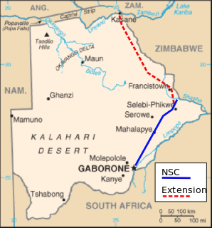
The North-South Carrier (NSC) is a pipeline in Botswana that carries raw water south for a distance of 360 kilometres (220 mi) to the capital city of Gaborone. Phase 1 was completed in 2000. Phase 2 of the NSC, under construction, will duplicate the pipeline to carry water from the Dikgatlhong Dam, which was completed in 2012. A proposed extension to deliver water from the Zambezi would add another 500 to 520 kilometres to the total pipeline length. The NSC is the largest engineering project ever undertaken in Botswana.

Botswana–South Africa border

The border between Botswana and South Africa is 1,969 kilometres (1,223 mi) long. More than 90% of the border follows rivers, including the Nossob, Molopo, Marico and Limpopo.

References

Sources