
The Great Victoria Desert, an interim Australian bioregion, is a sparsely populated desert area in Western Australia and South Australia.
Abrakurrie Cave is a wild cave on the Nullarbor Plain in Western Australia. It is located about 48 kilometres (30 mi) north west of Eucla and is reported to have the largest single cave chamber in the southern hemisphere, and that stencils in the cave are the deepest penetration of Aboriginal art of any cave system in Australia.

Eucla is the easternmost locality in Western Australia, located in the Goldfields-Esperance region of Western Australia along the Eyre Highway, approximately 11 kilometres (7 mi) west of the South Australian border. At the 2016 Australian census, Eucla had a population of 53.

Mamungari Conservation Park is a protected area located in South Australia within the southern Great Victoria Desert and northern Nullarbor Plain about 200 kilometres west of Maralinga and 450 kilometres northwest of Ceduna.
The Western Desert cultural bloc or just Western Desert is a cultural region in central Australia covering about 600,000 square kilometres (230,000 sq mi), including the Gibson Desert, the Great Victoria Desert, the Great Sandy and Little Sandy Deserts in the Northern Territory, South Australia and Western Australia. The Western Desert cultural bloc can be said to stretch from the Nullarbor in the south to the Kimberley in the north, and from the Percival Lakes in the west through to the Pintupi lands in the Northern Territory.
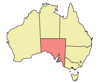
The geography of South Australia incorporates the south central part of the continent of Australia. It is one of the six states of Australia. South Australia is bordered on the west by Western Australia, to the north by the Northern Territory, Queensland to the northeast, and both New South Wales and Victoria to the east. South Australia's south coast is flanked by the Great Australian Bight and the Indian Ocean, although it is referred to locally as the Southern Ocean.
Fowlers Bay, formerly Yalata, is a town and locality in the Australian state of South Australia located about 658 kilometres (409 mi) north-west of the state capital, Adelaide. Situated on the Nullarbor Plain, it was once an active port and a gateway to the western reaches of the continent, but fell into decline in the 1960s. At the 2016 census, the localities of Fowlers Bay and Coorabie shared a population of 51.

Koonalda Cave is a cave in the Australian state of South Australia, on the Nullarbor Plain in the locality of Nullarbor. It is notable as an archeological site.

The Bunda cliffs are part of a larger scarp of the Eucla Basin that spreads from the western part of South Australia across to the south eastern corner of Western Australia. As a geographical feature, they form part of the longest uninterrupted line of sea cliffs in the world. No other continent or country can match the cliffs for length of coastline.

Nuyts Land District is a land district of Western Australia, located within the Eastern and Eucla land divisions on the Nullarbor Plain. It spans roughly 31°00'S - 32°50'S in latitude and 124°00'E - 125°30'E in longitude.

The Yellabinna Regional Reserve is a protected area in the Australian state of South Australia located about 30 kilometres north of Ceduna. To the west it borders Nullarbor Regional Reserve, to the south Yumbarra Conservation Park and Pureba Conservation Park. In the northwestern Section the 5,030 km2 Yellabinna Wilderness Protection Area (YWPA) is almost entirely surrounded by the Regional Reserve. The northern border in the western half of the reserve is formed by the Trans-Australian Railway.

Border Village is a settlement located in South Australia within the locality of Nullarbor on the Eyre Highway at the border with Western Australia.

Marrawijinie Cave is cave located in the Australian state of South Australia within the gazetted locality of Nullarbor on the Nullarbor Plain.
Nullarbor Wilderness Protection Area is a protected area in the Australian state of South Australia located about 270 kilometres west of Ceduna in the locality of Nullarbor.
Wilson Bluff is a coastal cliff on the Australian continental coastline, extending from east of Eucla in Western Australia to south of Border Village in South Australia.
This page is based on this
Wikipedia article Text is available under the
CC BY-SA 4.0 license; additional terms may apply.
Images, videos and audio are available under their respective licenses.


