Related Research Articles

Aragon is a census-designated place on the Tularosa River in Catron County, New Mexico, United States. As of the 2010 census it had a population of 94. It is located at an altitude of 7,135 feet (2,175 m), 7 miles (11 km) northeast of Apache Creek.
The Agua Caliente Band of Cahuilla Indians of the Agua Caliente Indian Reservation is a federally recognized tribe of the Cahuilla, located in Riverside County, California, United States. They inhabited the Coachella Valley desert and surrounding mountains between 5000 BCE and 500 CE. With the establishment of the reservations, the Cahuilla were officially divided into 10 sovereign nations, including the Agua Caliente Band.

The Agua Caliente Casino is a gambling facility, run by the Agua Caliente Band of Cahuilla Indians, in Rancho Mirage, California. The facility has over 45,000 square feet (4,200 m2) of gambling floor. The casino completed a 16-story, 173-foot (53 m) hotel tower which opened on April 18, 2008. The tower is the third-tallest building in the Inland Empire.

Ojo Caliente is an unincorporated community in Taos County, New Mexico, United States.
Ojo Caliente may mean:
The Battle of Ojo Caliente Canyon, or simply the Battle of Ojo Caliente was an engagement of the Jicarilla War on April 8, 1854. Combatants were Jicarilla Apache warriors, and their Ute allies, against the United States Army. The skirmish was fought as result of the pursuit of the Jicarilla after the Battle of Cieneguilla just over a week earlier.

Ojo Caliente Spring is a hot spring in Lower Geyser Basin, of Yellowstone National Park. It is in the River Group which includes Azure Spring, and is located a few yards off the Fountain Flats Freight Road on the northern bank of the Firehole River.
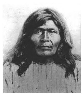
Victorio's War, or the Victorio Campaign, was an armed conflict between the Apache followers of Chief Victorio, the United States, and Mexico beginning in September 1879. Faced with arrest and forcible relocation from his homeland in New Mexico to San Carlos Indian Reservation in southeastern Arizona, Victorio led a guerrilla war across southern New Mexico, west Texas and northern Mexico. Victorio fought many battles and skirmishes with the United States Army and raided several settlements until the Mexican Army killed him and most of his warriors in October 1880 in the Battle of Tres Castillos. After Victorio's death, his lieutenant Nana led a raid in 1881.
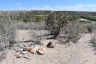
Canada Alamosa an Americanized version of the Spanish Cañada Alamosa, is a term historically applied to five geographical features, all in the same immediate area in southwest Socorro and northwest Sierra Counties, New Mexico. In historical texts the name, Canada Alamosa is applied inter-changeably to the five features, and it is often only the context that distinguishes one feature from the other.

The Rio Ojo Caliente is a tributary of the Rio Chama mostly in Rio Arriba County, New Mexico, with a small part near Ojo Caliente in Taos County.

Tahquitz Canyon is located in Palm Springs, California on a section of the Agua Caliente Indian Reservation. The canyon descends from the Riverside County San Jacinto Mountains. It was continually inhabited for at least 5,000 years by the Native American Cahuilla people, and is one of many canyons of cultural significance to the Cahuilla. Today it is a nature preserve open to the public that is overseen by the Agua Caliente Band of Cahuilla Indians.

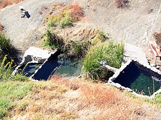
Faywood Hot Springs,, are thermal springs in Grant County, New Mexico, United States. It is located 2 miles (3.2 km) northeast of US 180 and .5 miles (0.80 km) west of NM 61, just south of the City of Rocks State Park. The hot springs have been visited since the time of the Mimbres culture. It was a successful resort in the late 19th century and early 20th century. In 1952, the establishment was demolished and became a ghost town. The land was purchased in 1993 and developed into a hot springs resort again.
McRae Canyon originally known as Cañon del Muerto, is a canyon in the southern Fra Cristobal Range in Sierra County, New Mexico. Its waters are tributary to the Rio Grande, and today flow into the Elephant Butte Reservoir at the head of an inlet in the flooded lower canyon, at an elevation of 4,354 feet. Its source is at 33°13′52″N107°05′50″W, at an elevation of 5,070 feet in the southern Fra Cristobal Range.
Posi-ouinge is an archeological site in Rio Arriba County, New Mexico and Taos County, New Mexico near Ojo Caliente. It was listed on the National Register of Historic Places in 1993 for its information potential.
Cañon del Muerto is a canyon, in Sierra County, New Mexico.
Fort McRae was a Union Army post, established in 1863, then a U.S. Army post from 1866 and closed in 1876, in what is now Sierra County, New Mexico. The post was named for Alexander McRae (1829–1862) a slain hero of the 1862 Battle of Valverde.
Spring Canyon is a canyon and tributary creek of Alamosa Creek in Socorro County, New Mexico. Its source is at an elevation if 6,850 feet, in the San Mateo Mountains to the north of Monticello Canyon at 33°35′23″N107°34′28″W. Its mouth is at an elevation if 6,174 feet near its creek,s confluence with Alamosa Creek.
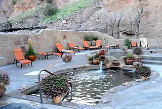
Ojo Caliente Hot Springs is a group of thermal springs located in Taos County, New Mexico, United States. They are also known as the Ojo Caliente Mineral Springs. These hot springs were used by native New Mexicans for many years. In the late 19th century the springs began to be developed for therapeutic use for several ailments, including tuberculosis.
Big Caliente Hot Springs are a grouping of thermal mineral springs located in the Los Padres National Forest of California.
References
Coordinates: 33°34′26″N107°35′38″W / 33.57389°N 107.59389°W
| | This New Mexico state location article is a stub. You can help Wikipedia by expanding it. |