
The Battle of Okinawa, codenamed Operation Iceberg, was a battle of the Pacific War fought on the island of Okinawa by United States Army and United States Marine Corps forces against the Imperial Japanese Army. The initial invasion of Okinawa on 1 April 1945 was the largest amphibious assault in the Pacific Theater of World War II. The Kerama Islands surrounding Okinawa were preemptively captured on 26 March by the 77th Infantry Division. The 82-day battle lasted from 1 April until 22 June 1945. After a long campaign of island hopping, the Allies were planning to use Kadena Air Base on the large island of Okinawa as a base for Operation Downfall, the planned invasion of the Japanese home islands, 340 mi (550 km) away.

Kyushu is the third-largest island of Japan's five main islands and the most southerly of the four largest islands. In the past, it has been known as Kyūkoku, Chinzei and Tsukushi-no-shima. The historical regional name Saikaidō referred to Kyushu and its surrounding islands. Kyushu has a land area of 36,782 square kilometres (14,202 sq mi) and a population of 14,311,224 in 2018.

Okinawa Prefecture is a prefecture of Japan. Okinawa Prefecture is the southernmost and westernmost prefecture of Japan and has a population of 1,457,162 and a geographic area of 2,281 km2.
Aka, AKA or a.k.a. may refer to:
Shimane Prefecture is a prefecture of Japan located in the Chūgoku region of Honshu. Shimane Prefecture is the second-least populous prefecture of Japan at 665,205 and has a geographic area of 6,708.26 km2. Shimane Prefecture borders Yamaguchi Prefecture to the southwest, Hiroshima Prefecture to the south, and Tottori Prefecture to the east.
Urasoe is a city located in Okinawa Prefecture, Japan. The neighboring municipalities are Naha to the south, Ginowan to the north, and Nishihara to the east. As of November 2012, the city has an estimated population of 113,718 and a population density of 5,956.9 persons per km2. The total area is 19.09 km2.

Itoman is a city located in Okinawa Prefecture, Japan. The city occupies the southern tip of Okinawa Island. As of April 2013, the city has an estimated population of 59,605 and a population density of 1,335.53 persons per km². The total area is 46.63 km².

The Sakishima Islands are an archipelago located at the southernmost end of the Japanese Archipelago. They are part of the Ryukyu Islands and include the Miyako Islands and the Yaeyama Islands. The islands are administered as part of Okinawa Prefecture, Japan.

The Kerama Islands are a subtropical island group 32 kilometres (20 mi) southwest of Okinawa Island in Japan.
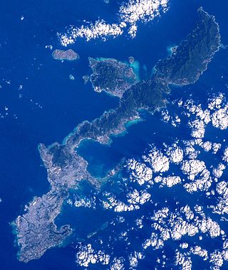
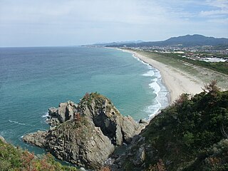
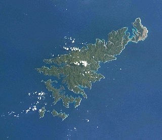
Okinawa Island, officially Okinawa Main Island is the largest of the Okinawa Islands and the Ryukyu (Nansei) Islands of Japan in the Kyushu region. It is the smallest and least populated of the five main islands of Japan. The island is approximately 106 kilometres (66 mi) long, an average 11 kilometres (7 mi) wide, and has an area of 1,206.98 square kilometers (466.02 sq mi). It is roughly 640 kilometres (400 mi) south of the main island of Kyushu and the rest of Japan. It is 500 km (300 mi) north of Taiwan. The total population of Okinawa Island is 1,384,762. The Greater Naha area has roughly 800,000 residents, while the city itself has about 320,000 people. Naha is the seat of Okinawa Prefecture on the southwestern part of Okinawa Island. Okinawa has a humid subtropical climate.
Amami Ōshima, also known as Amami, is the largest island in the Amami archipelago between Kyūshū and Okinawa. It is one of the Satsunan Islands.
Higashi is the Japanese word for east. In kanji it is represented as 東.

Uruma is a city located in Okinawa Prefecture, Japan. The modern city of Uruma was established on April 1, 2005, when the cities of Gushikawa and Ishikawa were merged with the towns of Katsuren and Yonashiro. As of May 1, 2013, the city has an estimated population of 118,330 and a population density of 1,400 people per km2. The total area is 86.00 km2. The city covers part of the east coast of the south of Okinawa Island, the Katsuren Peninsula, and the eight Yokatsu Islands. The Yokatsu Islands include numerous sites important to the Ryukyuan religion, and the city as a whole has numerous historical sites, including: Katsuren Castle, Agena Castle, and Iha Castle and the Iha Shell Mound. It is home to the largest venue for Okinawan bullfighting. The Mid-Sea Road, which crosses the ocean and connects the Yokatsu Islands to the main island of Okinawa, is now a symbol of Uruma.

New Ishigaki Airport,, also branded as Painushima Ishigaki Airport, is a regional airport located in the Shiraho district of Ishigaki, Okinawa Prefecture, Japan. The airport is located near the eastern coast of Ishigaki Island. It connects the island to major cities in Japan as well as destinations throughout Okinawa Prefecture and the Yaeyama Islands. New Ishigaki Airport was built to replace Ishigaki Airport, which with a shorter runway of only 1,500 metres (4,900 ft), could not accommodate larger jets.
Crime in Japan has been recorded since at least the 1800s, and has varied over time.
National Route 58 is a Japanese national highway connecting the capital cities Kagoshima and Naha of Kagoshima Prefecture and Okinawa Prefecture, respectively. With a total length of 884.4 kilometers (549.5 mi), it is the longest national highway in Japan, though it measures only 245.2 kilometers (152.4 mi) on land. The highway begins at an intersection with National Routes 3 and 10 in Kagoshima. From Kagoshima, it travels southwest along the first island chain that divides the Pacific Ocean from the East China Sea. From the north to the south, it has sections on the islands of Tanegashima, Amami Ōshima, and finally, Okinawa. On Okinawa it ends at an intersection with National Routes 330, 331, and 390 in Naha.

Naha is the capital city of Okinawa Prefecture, the southernmost prefecture of Japan. As of 1 June 2019, the city has an estimated population of 317,405 and a population density of 7,939 persons per km2. The total area is 39.98 km2 (15.44 sq mi)

Okinawa City is the second-largest city in Okinawa Prefecture, Japan, following Naha, the capital city. It is located in the central part of the island of Okinawa, about 20 kilometres (12 mi) north of Naha. As of December 2012, the city has an estimated population of 138,431 and a population density of 2,625.12 persons per km². The total area is 49.00 km².