Port Jackson, consisting of the waters of Sydney Harbour, Middle Harbour, North Harbour and the Lane Cove and Parramatta Rivers, is the ria or natural harbour of Sydney, New South Wales, Australia. The harbour is an inlet of the Tasman Sea. It is the location of the Sydney Opera House and Sydney Harbour Bridge. The location of the first European settlement and colony on the Australian mainland, Port Jackson has continued to play a key role in the history and development of Sydney.

Rose Bay is a harbourside, eastern suburb of Sydney, in the state of New South Wales, Australia. Rose Bay is located seven kilometres east of the Sydney central business district, in the local government areas of Waverley Council and Municipality of Woollahra.

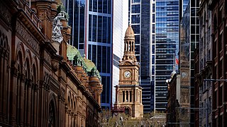
Town Hall railway station is a heritage-listed underground commuter rail station located in the centre of the Sydney central business district in New South Wales, Australia. The station opened on 28 February 1932. It is named after the Sydney Town Hall, located directly above the station.

The Macquarie Place Park, also known as the Macquarie Place Precinct, is a heritage-listed small triangular urban park located in the Sydney central business district in the City of Sydney local government area of New South Wales, Australia. The former town square and milestone and now memorial, public park and monument is situated on the corner of Bridge Street and Loftus Street. It is named in honour of Governor Lachlan Macquarie. The precinct includes The Obelisk or Macquarie Obelisk, the Sirius anchor and gun/cannon, the Statue of Thomas Sutcliffe Mort, the historic Underground Public Conveniences and the Christie Wright Memorial Fountain. The property was added to the New South Wales State Heritage Register on 5 March 2010.
The Eastern Suburbs is the metropolitan region directly to the east and south-east of the central business district in Sydney, New South Wales, Australia.

Kings Cross railway station is located on the Eastern Suburbs line, serving the Sydney suburb of Kings Cross. It is served by Sydney Trains T4 Eastern Suburbs & Illawarra Line services and NSW TrainLink South Coast Line services.

Paddington is an inner-city area of Sydney, in the state of New South Wales, Australia. Located 3 kilometres (1.9 mi) east of the Sydney central business district, Paddington lies across two local government areas. The portion south of Oxford Street lies within the City of Sydney, while the portion north of Oxford Street lies within the Municipality of Woollahra. It is often colloquially referred to as "Paddo".

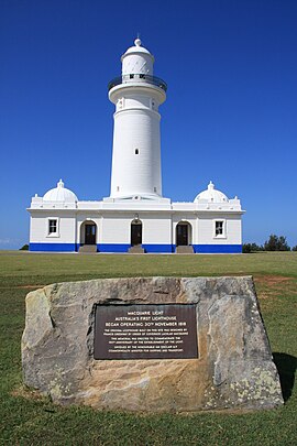
The Macquarie Lighthouse, also known as South Head Upper Light, was the first, and is the longest serving, lighthouse site in Australia. It is located on Dunbar Head, on the Old South Head Road, Vaucluse in the Municipality of Woollahra local government area of New South Wales, Australia. The lighthouse is situated approximately 2 kilometres (1 mi) south of South Head near the entrance to Sydney Harbour. There has been a navigational aid in this vicinity since 1791 and a lighthouse near the present site since 1818. The current heritage-listed lighthouse was completed in 1883. The lighthouse and associated buildings were designed by James Barnet and built from 1881 to 1883.

Watsons Bay is a harbourside, eastern suburb of Sydney, in the state of New South Wales, Australia. Watsons Bay is located 11 km north-east of the Sydney central business district, in the local government area of the Municipality of Woollahra.
Vaucluse is an eastern suburb of Sydney, in the state of New South Wales, Australia. It is located 8 kilometres (5 mi) north-east of the Sydney central business district, in the local government areas of Waverley Council and the Municipality of Woollahra.

Woollahra Municipal Council is a local government area in the eastern suburbs of Sydney, in the state of New South Wales, Australia. Woollahra is bounded by Sydney Harbour in the north, Waverley Council in the east, Randwick City in the south and the City of Sydney in the west.

Edgecliff railway station is located on the Eastern Suburbs line, serving the Sydney suburb of Edgecliff. It is served by Sydney Trains T4 Eastern Suburbs & Illawarra Line services and NSW TrainLink South Coast Line services.

Hornby Lighthouse, also known as South Head Lower Light or South Head Signal Station, is a heritage-listed active lighthouse located on the tip of South Head, New South Wales, Australia, a headland to the north of the suburb Watsons Bay. It marks the southern entrance to Port Jackson and Sydney Harbour, as well as lighting the South Reef, a ledge of submerged rocks. It is the third oldest lighthouse in New South Wales. Designed by Mortimer Lewis and listed on the Register of the National Estate and on the New South Wales State Heritage Register since 2 April 1999, with the following statement of significance:
A dominant Sydney landmark which appears to have been in continuous use since the 1840s as a controlling point for shipping entering and leaving Port Jackson. The building complex, designed by the Colonial Architect Mortimer Lewis in the early 1840s, is an architectural important example of an early Victorian public work associated with port activities.
John Horbury Hunt was a Canadian-born Australian architect who worked in Sydney and rural New South Wales from 1863.
The architecture of Sydney, Australia’s oldest city, is not characterised by any one architectural style, but by an extensive juxtaposition of old and new architecture over the city's 200-year history, from its modest beginnings with local materials and lack of international funding to its present-day modernity with an expansive skyline of high rises and skyscrapers, dotted at street level with remnants of a Victorian era of prosperity.
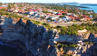
The Gap is an ocean cliff on the South Head peninsula in eastern Sydney, New South Wales, Australia. The area, which faces the Tasman Sea, is located in the eastern suburb of Watsons Bay, in the Municipality of Woollahra, near South Head. Although the cliff is a popular visitor destination, it has an infamy for suicides.

New South Head Road, is a major road in the Eastern Suburbs of Sydney. The road runs north-east from Rushcutters Bay through Edgecliff, Double Bay, Point Piper, Rose Bay and Vaucluse where it finally merges into Old South Head Road.

HMAS Watson is a Royal Australian Navy (RAN) base on Sydney Harbour at South Head, near Watsons Bay in Sydney, Australia. Commissioned in 1945, the base served as the RAN's radar training school. In 1956, torpedo and anti-submarine warfare training were relocated to the base, and by 2011, Watson was the main maritime warfare training base, as well as providing post-entry education for maritime warfare officers, training for combat system and electronic warfare sailors, and command training.

Mosman is a suburb on the Lower North Shore of Sydney, in the state of New South Wales, Australia. Mosman is located 8 kilometres north-east of the Sydney central business district and is the administrative centre for the local government area of the Municipality of Mosman.

The South Head General Cemetery is a heritage-listed cemetery located at 793 Old South Head Road, Vaucluse, Waverley Municipality, New South Wales, Australia. It was built from 1868 to 1950. It is also known as Old South Head Cemetery and the South Head Cemetery. The property is owned by Waverley Municipal Council. It was added to the New South Wales State Heritage Register on 25 August 2017.