The Limpopo River rises in South Africa, and flows generally eastwards to the Indian Ocean in Mozambique. The term Limpopo is derived from Rivombo (Livombo/Lebombo), a group of Tsonga setters led by Hosi Rivombo who settled in the mountainous vicinity and named the area after their leader. The river is approximately 1,750 kilometres (1,087 mi) long, with a drainage basin 415,000 square kilometres (160,200 sq mi) in size. The mean discharge measured over a year is 170 m3/s at its mouth. The Limpopo is the second largest river in Africa that drains to the Indian Ocean, after the Zambezi River.

The Olifants River, Lepelle or Obalule is a river in South Africa and Mozambique, a tributary of the Limpopo River. It falls into the Drainage Area B of the Drainage basins of South Africa. The historical area of the Pedi people, Sekhukhuneland, is located between the Olifants River and one of its largest tributaries, the Steelpoort River.
Limpopo WMA, or Limpopo Water Management Area(coded: 1), in South Africa includes the following major rivers: the Limpopo River, Matlabas River, Mokolo River, Lephalala River, Mogalakwena River, Sand River and Nzhelele River and covers the following dams.
Olifants WMA, or Olifants Water Management Area , Includes the following major rivers: the Elands River, Wilge River, Steelpoort River and Olifants River, and covers the following dams:
Mzimvubu to Keiskamma WMA, or Mzimvubu to Keiskamma Water Management Area , includes the following major rivers: the Swane River, Mntafufu River, Mzimvubu River, Mngazi River, Mthatha River, Xora River, Mbashe River, Nqabara River, Gqunube River, Buffalo River, Nahoon River, Groot Kei River and Keiskamma River, and covers the following Dams:
Fish to Tsitsikama WMA, or Fish to Tsitsikama Water Management Area , in South Africa Includes the following major rivers: the Fish River, Kowie River, Boesmans River, Sundays River, Gamtoos River, Kromme River, Tsitsikamma River and Groot River, and covers the following Dams:
Gouritz WMA, or Gouritz Water Management Area , in South Africa includes the following major rivers: the Gouritz River, Olifants River, Kamanassie River, Gamka River, Buffels River, Touws River, Goukou River and Duiwenhoks River, and covers the following Dams:
Berg WMA, or Berg Water Management Area , Include the following major rivers: the Berg River, Diep River and Steenbras River, and covers the following Dams:
Breede WMA, or Breede Water Management Area , Includes the following major rivers: the Breede River, Riviersonderend River, Sout River, Bot River and Palmiet River, and covers the following Dams:

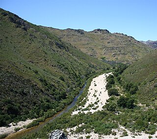
The Blyde River, Motlatse River, or Umdhlazi River is a river in the Mpumalanga and Limpopo provinces of South Africa. It has a northwards course in steep-sided valleys and ravines of the Mpumalanga Drakensberg, before it enters the lowveld region of the Limpopo province. It has its ultimate origins at around 2,000 m altitude in the Hartebeesvlakte conservation area, to the north of Long Tom Pass. It runs through the Blyde River Canyon.

The Levubu River or Levuvhu is located in the northern Limpopo province of South Africa. Some of its tributaries, such as the Mutshindudi River and Mutale River rise in the Soutpansberg Mountains.

The Doring River is a river in the Western Cape Province, South Africa. It is part of the Olifants/Doring River system.
The Touws River is a river in the Western Cape province of South Africa. It is a tributary of the Groot River, part of the Gourits River basin.
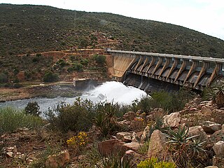
The Kouga River originates near Uniondale, Eastern Cape, South Africa, and flows eastward, where it joins the Groot River to form the Gamtoos just past the Kouga Dam. Its main tributary is the Baviaanskloof River, which joins its left bank before the dam.

The Letaba River, also known as Leţaba, Lehlaba or Ritavi, is a river located in eastern Limpopo Province, South Africa. It is one of the most important tributaries of the Olifants River.

The Shingwedzi River, is a river in Limpopo Province, South Africa and Gaza Province, Mozambique. It is a left hand tributary of the Olifants River (Rio dos Elefantes) and the northernmost river of its catchment area, joining it at the lower end of its basin. The Shingwedzi is a seasonal river whose riverbed is dry for prolonged periods.