Osceola, Wisconsin

Last updated

Osceola
Village
Polk County Wisconsin Incorporated and Unincorporated areas Osceola Highlighted.svg
Location of Osceola in Polk County, Wisconsin.
USA Wisconsin location map.svg
Red pog.svg
Osceola
Location within the state of Wisconsin
Coordinates: 45°19′21″N92°41′55″W / 45.32250°N 92.69861°W / 45.32250; -92.69861
Country Flag of the United States.svg  United States
State Flag of Wisconsin.svg  Wisconsin
County Polk
Area
[1]
  Total4.19 sq mi (10.84 km2)
  Land4.06 sq mi (10.52 km2)
  Water0.13 sq mi (0.33 km2)
Population
 (2010) [2]
  Total2,568
  Estimate 
(2019) [3]
2,556
  Density629.56/sq mi (243.05/km2)
Time zone UTC-6 (Central (CST))
  Summer (DST) UTC-5 (CDT)
ZIP codes
54020
Area code(s) 715 & 534
FIPS code 55-60450
Website Official website

Osceola is a village in Polk County, Wisconsin, United States. The population was 2,765 at the 2020 census. Located mostly within the Town of Osceola, the village sits on the border with Minnesota, separated by the St. Croix River. It is along Wisconsin Highway 35.

Contents

The Village Board has articulated the 10 most significant assets and given them the name "the Power of 10". They are: 1) Schools; 2) Airport (the Osceola Municipal Airfield); 3) Industrial Park; 4) the St. Croix River; 5) the Cascade Falls; 6) Downtown Businesses; 7) Personalization/Historic Feel of Downtown; 8) access to a major population center (Minneapolis/St. Paul Metropolitan Region); 9) Medical Services; Tie for 10/11) Recreational opportunities and the Braves. [4]

History

The village was named after Osceola, chief of the Seminoles. [5]

Tourism

The Village of Osceola was named the Most Charming Small Town in Wisconsin in 2022, by Trips to Discover. [6]

Forbes Magazine has written about some of the things to do during a visit to Osceola. [7]

Business District

The Village of Osceola created a Business Improvement District [(BID)] in 2023. [8]

Geography

Osceola is located at 45°19′20″N92°41′54″W / 45.32222°N 92.69833°W / 45.32222; -92.69833 (45.322365, -92.698534). [9] Cascade Falls, a 25-foot (7.6 m) waterfall with a 30-foot (9.1 m) crest on Osceola Creek, is located in downtown Osceola.

According to the United States Census Bureau, the village has a total area of 4.32 square miles (11.19 km2), of which, 4.19 square miles (10.85 km2) of it is land and 0.13 square miles (0.34 km2) is water. [10]

Demographics

Historical population
CensusPop.Note
1880 311
1890 38423.5%
1900 46621.4%
1910 63436.1%
1920 6746.3%
1930 607−9.9%
1940 6425.8%
1950 7009.0%
1960 94234.6%
1970 1,15222.3%
1980 1,58137.2%
1990 2,07531.2%
2000 2,42116.7%
2010 2,5686.1%
2019 (est.)2,556 [3] −0.5%
U.S. Decennial Census [11]

2020 census

As of the census [2] of 2020, there were 2,765 people, and 1,224 households living in the village. There were 1,356 housing units. The racial makeup of the village was 94.1% White, 0.7% African American, 0.5% Native American, 0.65% Asian, 1% from other races, and 3% from two or more races. Hispanic or Latino of any race were 7.05% of the population when subtracting those saying they were not in this category. Only 0.2% stated this explicitly. Median Gross rents were $875. 53.2% of the residents were homeowners.

There were 1,224 households, of which 24.6% had children under the age of 18 living with them. 6.4% of households had children were under the age of 5, 14% in the 5 to 14 year range and 4.2% had children ages 15 to 17. 41.5% were married couples family households, 35% had a female householder with no husband present, 13.2% had a male householder with no wife present, and 42.2% were non-families. 45.6% were married (except separated), 9% were widowed, 18.1% were divorced, and 0.4% were separated. 26.9% had never married. 17.3% of the population was 65 years or older. 6.2% were veterans.

The median age in the village was 37.1 years. The average household income was $50,938 and 13.8% of the population was in poverty. 19.4% of the village residents have attained a Bachelor's Degree or higher. Manufacturing was the top industry and employed 31.6% of the labor force. This was followed by education at 19.8%, retail trade at 10.4% and arts/entertainment/recreation at 8.4%.

2010 census

As of the census [2] of 2010, there were 2,568 people, 1,142 households, and 660 families living in the village. The population density was 612.9 inhabitants per square mile (236.6/km2). There were 1,289 housing units at an average density of 307.6 per square mile (118.8/km2). The racial makeup of the village was 96.0% White, 0.3% African American, 0.3% Native American, 1.0% Asian, 0.9% from other races, and 1.6% from two or more races. Hispanic or Latino of any race were 2.1% of the population.

There were 1,142 households, of which 32.7% had children under the age of 18 living with them, 38.6% were married couples living together, 13.2% had a female householder with no husband present, 6.0% had a male householder with no wife present, and 42.2% were non-families. 36.0% of all households were made up of individuals, and 11.5% had someone living alone who was 65 years of age or older. The average household size was 2.25 and the average family size was 2.91.

The median age in the village was 36.4 years. 26.1% of residents were under the age of 18; 7.1% were between the ages of 18 and 24; 27.4% were from 25 to 44; 26.6% were from 45 to 64; and 12.8% were 65 years of age or older. The gender makeup of the village was 47.3% male and 52.7% female.

2000 census

As of the census [12] of 2000, there were 2,421 people, 1,002 households, and 615 families living in the village. The population density was 656.9 people per square mile (253.3/km2). There were 1,072 housing units at an average density of 290.9 per square mile (112.2/km2). The racial makeup of the village was 97.44% White, 0.37% Black or African American, 0.33% Native American, 0.21% Asian, 0.37% from other races, and 1.28% from two or more races. 0.91% of the population were Hispanic or Latino of any race.

There were 1,002 households, out of which 35.5% had children under the age of 18 living with them, 44.9% were married couples living together, 12.0% had a female householder with no husband present, and 38.6% were non-families. 31.3% of all households were made up of individuals, and 10.8% had someone living alone who was 65 years of age or older. The average household size was 2.38 and the average family size was 3.01.

In the village, the population was spread out, with 27.9% under the age of 18, 9.8% from 18 to 24, 32.9% from 25 to 44, 16.7% from 45 to 64, and 12.7% who were 65 years of age or older. The median age was 33 years. For every 100 females, there were 92.4 males. For every 100 females age 18 and over, there were 88.2 males.

The median income for a household in the village was $39,000, and the median income for a family was $45,846. Males had a median income of $33,017 versus $22,453 for females. The per capita income for the village was $18,921. About 4.3% of families and 6.1% of the population were below the poverty line, including 7.2% of those under age 18 and 6.0% of those age 65 or over.

Education

Osceola is served by the Osceola School District. Osceola High School has grades 9-12.

Transportation

L.O. Simenstad Municipal Airport (KOEO), serves the village and surrounding communities. In 2006, a glider club was based there. Osceola Aerosport provides aviation training. [13]

The Soo Line Depot offers train rides on the Osceola and St. Croix Valley Railway. [14]

Museum

The Osceola and St Croix Valley Railway Museum is in Osceola, operating out of the historic 1916 Soo Line Depot. The railway moved to Osceola in 1992.[ citation needed ]

Notable people

Related Research Articles

<span class="mw-page-title-main">Webster, Burnett County, Wisconsin</span> Village in Wisconsin, United States

Webster is a village in Burnett County in the U.S. state of Wisconsin. The population was 653 at the 2010 census. It is along Wisconsin Highway 35.

<span class="mw-page-title-main">Downing, Wisconsin</span> Village in Wisconsin, United States

Downing is a village in Dunn County, Wisconsin, United States. Bordering St. Croix County to the west, the village is otherwise surrounded by the Town of Tiffany. The population was 234 at the 2020 census.

<span class="mw-page-title-main">Dresser, Wisconsin</span> Village in Wisconsin, United States

Dresser is a village in Polk County, Wisconsin, United States. The population was 895 at the 2010 census. It is along Wisconsin Highway 35.

<span class="mw-page-title-main">Deer Park, Wisconsin</span> Village in Wisconsin, United States

Deer Park is a village in St. Croix County, Wisconsin, United States. The population was 216 at the 2010 census.

<span class="mw-page-title-main">Glenwood City, Wisconsin</span> City in Wisconsin, United States

Glenwood City is a city in St. Croix County, Wisconsin, United States. The population was 1,242 at the 2010 census. Glenwood City is the site of the yearly St. Croix County fair and is known as the "City of 57 Hills."

<span class="mw-page-title-main">Roberts, Wisconsin</span> Village in Wisconsin, United States

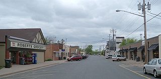
Roberts is a village in St. Croix County, Wisconsin, United States. The population was 1,651 at the 2010 census. The village is surrounded by the town of Warren.

<span class="mw-page-title-main">Wilson, St. Croix County, Wisconsin</span> Village in Wisconsin, United States

Wilson is a village in St. Croix County, Wisconsin, United States. The population was 184 at the 2010 census.

<span class="mw-page-title-main">Woodville, Wisconsin</span> Village in Wisconsin, United States

Woodville is a village in St. Croix County, Wisconsin, United States. The population was 1,344 at the 2010 census.

<span class="mw-page-title-main">Dorchester, Wisconsin</span> Village in Wisconsin, United States

Dorchester is a village in Clark and Marathon counties in the U.S. state of Wisconsin, along the 45th parallel. It is part of the Wausau, Wisconsin Metropolitan Statistical Area. The population was 876 at the 2010 census. Of this, 871 were in Clark County, and only 5 were in Marathon County.

<span class="mw-page-title-main">Spring Valley, Wisconsin</span> Village in Wisconsin, United States

Spring Valley is a village in Pierce and St. Croix counties in Wisconsin, United States. The population was 1,401 at the 2020 census. Of those, 1,390 were in Pierce County and 11 in St. Croix County. The village is mostly within the Town of Spring Lake in Pierce County. Small parts also lie in the Town of Gilman, also in Pierce County, and the Town of Cady in St. Croix County.

<span class="mw-page-title-main">Turtle Lake, Wisconsin</span> Village in Wisconsin, United States

Turtle Lake is a village in Barron and Polk counties in the U.S. state of Wisconsin. Its population was 1,064 at the 2010 census. Of these, 972 were in Barron County and 93 were in Polk County. The village is located between the towns of Almena, in Barron County, and Beaver, in Polk County.

<span class="mw-page-title-main">Grantsburg, Wisconsin</span> Village in Wisconsin, United States

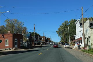
Grantsburg is a village in Burnett County, Wisconsin, United States. The population was 1,341 at the 2010 census. The village is located within the Town of Grantsburg. It was established by Canute Anderson.

<span class="mw-page-title-main">Milltown, Wisconsin</span> Village in Wisconsin, United States

Milltown is a village in Polk County, Wisconsin, United States. The population was 917 at the 2010 census. The village is located within the Town of Milltown.

<span class="mw-page-title-main">Osceola, Polk County, Wisconsin</span> Town in Wisconsin, United States

Osceola is a town in Polk County, Wisconsin, United States. The population was 2,085 at the 2000 census. The village of Osceola is located mostly within the town. The unincorporated community of Nye is also located in the town.

<span class="mw-page-title-main">St. Croix Falls (town), Wisconsin</span> Town in Wisconsin, United States

St. Croix Falls is a town in Polk County, Wisconsin, United States. The population was 1,119 at the 2000 census. The City of St. Croix Falls is located within the town. The unincorporated community of Lamar is located in the town.

<span class="mw-page-title-main">St. Croix Falls, Wisconsin</span> City in Wisconsin, United States

St. Croix Falls is a city in Polk County, Wisconsin, United States. The population was 2,208 at the 2020 census. The city is located within the Town of St. Croix Falls.

<span class="mw-page-title-main">Hammond, Wisconsin</span> Village in Wisconsin, United States

Hammond is a village in St. Croix County, Wisconsin, United States. The population was 1,922 at the 2010 census. The village is located within the Town of Hammond. Hammond was home to the Running of the Llamas.

Somerset is a town in St. Croix County, Wisconsin, United States. The population was 4,036 at the 2010 census. The Village of Somerset is adjacent to the town.

<span class="mw-page-title-main">Star Prairie, Wisconsin</span> Village in Wisconsin, United States

Star Prairie is a village in St. Croix County in the U.S. state of Wisconsin. The population was 561 at the 2010 census. The village is located along the Apple River on the boundary between the Town of Star Prairie and the Town of Stanton.

Star Prairie is a town in St. Croix County, Wisconsin, United States. The population was 2,944 at the 2000 census. The Village of Star Prairie is located on the eastern boundary of the town. The unincorporated communities of Huntington and Johannesburg are located in the town.

References

  1. "2019 U.S. Gazetteer Files". United States Census Bureau. Retrieved August 7, 2020.
  2. 1 2 3 "U.S. Census website". United States Census Bureau . Retrieved November 18, 2012.
  3. 1 2 "Population and Housing Unit Estimates". United States Census Bureau. May 24, 2020. Retrieved May 27, 2020.
  4. "Village of Osceola Board Meeting; December 14, 2021" (PDF). Retrieved January 1, 2023.
  5. Chicago and North Western Railway Company (1908). A History of the Origin of the Place Names Connected with the Chicago & North Western and Chicago, St. Paul, Minneapolis & Omaha Railways. p. 163.
  6. "The Most Charming Small Town in Every State".
  7. Koutsky, Judy. "Forbes Magazine". Forbes .
  8. "BID program proposed for downtown Osceola". May 5, 2022.
  9. "US Gazetteer files: 2010, 2000, and 1990". United States Census Bureau. February 12, 2011. Retrieved April 23, 2011.
  10. "US Gazetteer files 2010". United States Census Bureau. Archived from the original on January 25, 2012. Retrieved November 18, 2012.
  11. "Census of Population and Housing". Census.gov. Retrieved June 4, 2015.
  12. "U.S. Census website". United States Census Bureau . Retrieved January 31, 2008.
  13. "Osceola AeroSport". www.osceolaaero.com. Retrieved January 2, 2023.
  14. "See a New Side of the St. Croix Valley on This Train Tour". August 2020.