Dhanushkodi is an abandoned town at the south-eastern tip of Pamban Island of the state of Tamil Nadu in India. It is situated to the South-East of Pamban and is about 18 miles (29 km) west of Talaimannar in Sri Lanka. The town was destroyed during the 1964 Rameswaram cyclone and remains uninhabited in the aftermath.

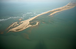
Adam's Bridge, also known as Rama's Bridge or Rama Setu, is a chain of limestone shoals, between Pamban Island, also known as Rameswaram Island, off the south-eastern coast of Tamil Nadu, India, and Mannar Island, off the north-western coast of Sri Lanka. Geological evidence suggests that this bridge is a former land connection between India and Sri Lanka.

The Palk Strait is a strait between the Tamil Nadu state of India and the Mannar district of the Northern Province of the island nation of Sri Lanka. It connects the Bay of Bengal in the northeast with Palk Bay in the southwest. The strait is 53 to 82 kilometres wide. Several rivers flow into it, including the Vaigai River of Tamil Nadu. The strait is named after Robert Palk, who was a governor of Madras (1755–1763) during the Company Raj period.

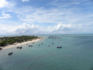
Rameswaram is a town and municipality in the Ramanathapuram district of the Indian state of Tamil Nadu. It is on Pamban Island separated from mainland India by the Pamban channel and is about 40 kilometres from Mannar Island, Sri Lanka. It is in the Gulf of Mannar, at the tip of the Indian peninsula. Pamban Island, also known as Rameswaram Island, is connected to mainland India by the Pamban Bridge. Rameswaram is the terminus of the railway line from Chennai and Madurai. Together with Varanasi, it is considered to be one of the holiest places in India to Hindus, and part of the Char Dham pilgrimage.

The Strait of Georgia or the Georgia Strait is an arm of the Pacific Ocean between Vancouver Island and the extreme southwestern mainland coast of British Columbia, Canada and the extreme northwestern mainland coast of Washington, United States. It is approximately 240 kilometres (150 mi) long and varies in width from 20 to 58 kilometres. Along with the Strait of Juan de Fuca and Puget Sound, it is a constituent part of the Salish Sea. Archipelagos and narrow channels mark each end of the Strait of Georgia, the Gulf Islands and San Juan Islands in the south, and the Discovery Islands in the north. The main channels to the south are Boundary Pass, Haro Strait and Rosario Strait, which connect the Strait of Georgia to the Strait of Juan de Fuca. In the north, Discovery Passage is the main channel connecting the Strait of Georgia to Johnstone Strait. The strait is a major navigation channel on the west coast of North America, owing to the presence of the port of Vancouver, and also due to its role as the southern entrance to the intracoastal route known as the Inside Passage.

A bascule bridge is a moveable bridge with a counterweight that continuously balances a span, or "leaf", throughout its upward swing to provide clearance for boat traffic. It may be single- or double-leafed.
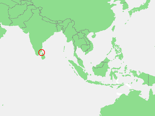
The Gulf of Mannar is a large shallow bay forming part of the Laccadive Sea in the Indian Ocean. It lies between the west coast of Sri Lanka and the southeastern tip of India, in the Coromandel Coast region. The chain of low islands and reefs known as Ramsethu, also called Adam's Bridge, which includes Mannar Island, separates the Gulf of Mannar from Palk Bay, which lies to the north between Sri Lanka and India. The Malvathu Oya of Sri Lanka and the estuaries of Thamirabarani River and Vaipar River of South India drain into the Gulf. The dugong is found here.
Ramanathapuram District is an administrative district of Tamil Nadu state in southern India. The town of Ramanathapuram is the district headquarters. Ramanthapuram District has an area of 4123 km2. It is bounded on the north by Sivaganga District, on the northeast by Pudukkottai District, on the east by the Palk Strait, on the south by the Gulf of Mannar, on the west by Thoothukudi District, and on the northwest by Virudhunagar District. The district contains the Pamban Bridge, an east-west chain of low islands and shallow reefs that extend between India and the island nation of Sri Lanka, and separate the Palk Strait from the Gulf of Mannar. The Palk Strait is navigable only by shallow-draft vessels. It also contains Theriruveli, a small village. As of 2011, Ramanathapuram district had a population of 1,353,445 with a sex-ratio of 983 females for every 1,000 males.

Mannar Island formerly spelt Manar Island, is part of Mannar District, Sri Lanka. It is linked to the main island of Sri Lanka by a causeway. It has an area of about 50 square kilometres, mainly covered with vegetation and sand. Adam's Bridge, is a chain of limestone shoals, between Pamban Island, also known as Rameswaram Island, off the southeastern coast of Tamil Nadu, India, and Mannar Island, off the northwestern coast of Sri Lanka. Geological evidence suggests that this bridge is a former land connection between India and Sri Lanka.

Talaimannar is a settlement in Sri Lanka located on the northwestern coast of Mannar Island.
Cross-sea traffic ways are vehicle or railroad traffic ways across the sea. Such traffic ways could include bridges or tunnels.
Mt. Gandhamadana is the tallest peak on Pamban Island which lies in the Palk Strait between mainland India and Sri Lanka.
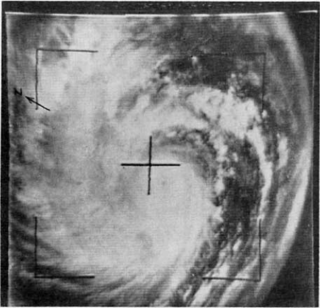
The 1964 Rameswaram cyclone was regarded as one of the most powerful storms to ever strike India on record. The system was first identified as an area of low pressure over the Andaman Sea on December 15. Following interaction with a tropical wave, it began to develop and became a depression by December 18. Increasingly rapid intensification ensued over the following days with the cyclone attaining hurricane-force winds around 5°N the next day. Early on December 23, the storm struck Ceylon near Pamban Island with winds estimated at 240 km/h (150 mph), ranking it as a modern-day super cyclonic storm. Weakening somewhat, the storm soon struck Tamil Nadu. Rapid weakening followed once the cyclone was onshore and it degenerated into a depression on December 24 as it emerged over the Arabian Sea. The system later dissipated on December 26 over open water.

Rameswaram railway station is a railway station serving the town of Rameswaram located on the Rameswaram Island in the Ramnad district of Tamil Nadu. It is belongs to the Madurai railway division and is an important terminal of the Southern Railway Zone. The station links the pilgrim town as well as the rest of the island to the mainland via the highly acclaimed Pamban Rail Bridge.

The Palk Strait bridge was a proposed 23-kilometre (14 mi) bridge over the Palk Strait, between Dhanushkodi in mainland India, and Talaimannar in Sri Lanka. The proposal, from Indian Transport Minister Nitin Gadkari, was submitted to the Asian Development Bank in June 2015. In December 2015, the Lankan Minister of Highways, Lakshman Kiriella, dismissed the proposal.


