
Kottayam is one of 14 districts in the Indian state of Kerala. Kottayam district comprises six municipal towns: Kottayam, Changanassery, Pala, Erattupetta, Ettumanoor, and Vaikom. It is the only district in Kerala that neither borders the Arabian Sea nor any other states.

Meenachil is the north-eastern region of Kottayam district in Kerala, south India. The name originates from Meenakshi, the Hindu Goddess. Pala is the main city in Meenachil. The arterial river of the district is also named Meenachil.

Kanjirappally is a taluk and a town in Kottayam district situated about 38 km (24 mi) away from the district capital, in the state of Kerala, India.
Mundakayam, is a town in Kanjirappally Taluk in the Kottayam District of Kerala. It is the doorway to the high ranges of southern Kerala, and is at the border of Kottayam and Idukki districts. The next nearest town, Kanjirappally, is 14 km (8.7 mi) & Erumely is 12 km from Mundakayam. Mundakayam has rubber plantations, and greenery. The Manimala River runs through Mundakayam. It is located 48 km east of the district headquarters at Kottayam and 148 km from the state capital, Thiruvananthapuram. The name Mundakayam is said to be derived from the Mundi cranes that used to be seen along the Manimala River banks.
Koottickal is a town at the base of Western Ghats mountain ranges in the Kottayam district, Kerala. It is 2,000 feet (610 m) above sea level and is situated on the eastern border of Kottayam District, 55 km from Kottayam, and around 5 km away from Mundakayam on the NH 220. There are streams and waterfalls in the surrounding places. The Muthukora Hills are nearby. Urban centres in Kottayam and Ernakulam districts can be viewed from the top of Muthukora Hills.

Perunilam is a small Village/hamlet in Meenachil Taluk in Kottayam district of Kerala State, India. It comes under Poonjar Panchayath. It belongs to South Kerala Division. It is located 44 km East from District headquarters Kottayam. 2.5 km from Erattupetta. 149 km from State capital Thiruvananthapuram. Main agricultural crop is rubber. The popular Christian Pilgrim Centre Bharananganam and St. George's Syro-Malabar Catholic Forane Church, Aruvithura is near to Perunilam. Perunilam Kurishupally is located in Perunilam. Malayalam is the Local Language here. Kottayam Rail Way Station is major railway station 40 km near to Perunilam.

The Archeparchy of Changanacherry is a Syro-Malabar Catholic archeparchy with an area of 24,595 km2 comprising the districts of Kottayam, Alappuzha, Pathanamthitta, Kollam, and Thiruvananthapuram in Kerala, and also Kanyakumari district in Tamil Nadu. It is one of the largest Catholic dioceses in India in terms of area. Joseph Perumthottam is the current Metropolitan Archbishop, serving since 2007. Thomas Tharayil has been the auxiliary bishop since 2017. Suffragan eparchies of the Changanassery archeparchy includes Palai, Kanjirappally-Nilackal, and Thuckalay-Thiruvithancode.
The Main Central Road popularly known as MC Road is the arterial State Highway starting from Kesavadasapuram in Trivandrum city and ends at Angamaly, a suburb of Kochi city in Ernakulam District, in the state of Kerala, India. It is designated as State Highway 1 by the Kerala Public Works Department. The highway was built by Raja Kesavadas, Dewan of Travancore, in the 1790s. Plan for a new highway called Thiruvananthapuram–Angamaly Greenfield Highway, which runs parallel to the MC Road is proposed and is under early stage of development.

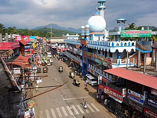
Ponkunnam is a census town in Kerala, India, part of Kottayam district under Kanjirappally taluk. Ponkunnam literally means golden mountain (ponn = gold, kunn = mountain). Nearby towns are Kanjirappalli, Manimala and Pala. This part of Kerala is famous for its fertile land and rubber plantations. It is at an altitude of 495 ft (151 m) above mean sea level. The town is at the junction of two major roads in Kerala: NH 183 and Main Eastern Highway. The climate is moderate with timely cold breezes and the town is the gateway to the Western Ghats. The town is famous for its volleyball traditions and customs. Almost every year there is an ever-rolling volleyball tournament happening in Ponkunnam Mahatma Gandhi Mini Stadium.
Teekoy is a southern Indian village, situated in the eastern part of Kottayam district in Kerala state.

Poonjar is a small Indian town located on the eastern side of Kottayam district in Kerala state, India. Before the independence of India, Poonjar had been the part of Travancore princely state.Erattupetta, Teekoy, bharananganam, and vagamon are the nearest towns and villages of Poonjar.Taluk headquarters,pala is 18 kilometres away from poonjar and kanjirapally is 22.6 kilometres away from poonjar

Kumily, also spelt as Kumaly is a revenue village and Gram Panchayat in the Idukki district of Kerala. It is a town in Cardamom Hills near Thekkady and Periyar Tiger Reserve. Kumily is a gateway town into Kerala from Tamil Nadu.

Mallikassery is a small village near Paika, in Elikulam Panchayat of Kanjirappally Taluk in Kottayam district, in the state of Kerala, India.

Erumely, also spelt Erumeli, is a town and panchayat located in the south-eastern part of Kottayam district in Kerala state, India. Erumely is situated 49 km (30 mi) east of Kottayam town and 133 km (83 mi) north of capital city Thiruvananthapuram. It is situated on the way to Sabarimala and during pilgrimage season, Erumely and its surroundings will be crowded by devotees from different parts of Kerala as well as other states. Erumely is also renowned for its religious harmony and prosperity between Hindus and Muslims which existed from the early periods. It is a place which have strong roots in legends and myths associated with Hindu deity Ayyappa. A new airport has been proposed in Erumeli. The village is nourished by Manimala River.

Yendayar is a village in Kottayam district, Kerala, India that is totally surrounded by hills. According to local tradition, Mr. J.J. Murphy named the place, which was to be his home until death in 1957, after his mother and the local river. Yendayar is a combination of 'yen' (my) 'thai' (mother) and 'ar' (river). Murphy had come in 1904 to the place which was a thick forest and had no name or people then. He had traveled a long way to reach there. There he established India's first successful rubber plantation. He brought workers from near and far – Kerala, Tamil Nadu, and Karnataka.
Chemmalamattam, is a village in the Kottayam district of Kerala, India. It is located about 40 km east of Kottayam and 19 km west of Mundakkayam and is 9.5 km north of Kanjirappally towards Erattupetta.
Neeloor is an agriculture-oriented rural village in the Taluk of Meenachil, Kottayam district, Kerala. The village is situated on the hill sides of Noorumala, Ellumpuram and Perumkunnu which are hills on the borders of Kottayam district and the neighboring Idukki district. Earlier the place was known as "Kallidapootha".
Koruthodu is a village/town in Kanjirappally Taluk, Kottayam District of Kerala state, India. It is situated on the Highway connecting Mundakayam to Sabarimala temple, Kerala, and is at the border of Pathanamthitta, Kottayam and Idukki districts. The nearest town Mundakayam is 13 Kilometers from Koruthodu. The river Azhutha runs through the borders of this village. Nearby locations include Kanamala, Vandanpathal, Mundakkayam and Panakkachira.
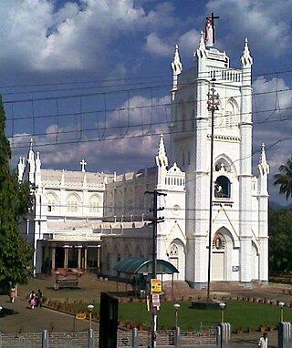
Aruvithura Church is a Syro-Malabar Catholic church located at Aruvithura,Eratupetta Kottayam district in the Kerala State of India. Traditionally it is believed that the Syrian Catholic Church at Erattupetta was established in AD 151.