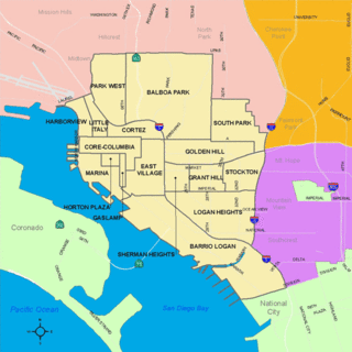
Logan Heights is a neighborhood in central San Diego, California. It is bordered by Interstate 5 on the south and west, Interstate 15 on the east, and Imperial Avenue on the north.
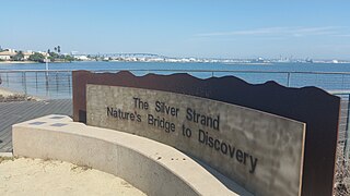
Silver Strand, or simply The Strand, is a low, narrow, sandy isthmus or tombolo 7 miles (11 km) long in San Diego County, California partially within the Silver Strand State Beach. It connects Coronado Island with Imperial Beach. Together with the Point Loma peninsula it shelters and defines San Diego Bay. State Route 75 (SR 75) runs the length of the strand and is a popular site for jogging and bicycling. The Silver Strand Half Marathon is run along the route each November.
San Carlos is a neighborhood in the eastern area of San Diego, California. It borders the neighborhoods of Del Cerro, Tierrasanta, and Allied Gardens, the city of La Mesa, and Mission Trails Regional Park. The neighborhood extends to Cowles Mountain at the north.
Navajo is a hilly community in the eastern part of San Diego, California. It is a designated planning area for the city of San Diego. It includes the neighborhoods of Del Cerro, Grantville, San Carlos, and Allied Gardens.

The Marina district is a neighborhood in the southwest section of Downtown San Diego, California along the San Diego Bay.

Encanto is a hilly neighborhood located in the southeastern part of San Diego, California. The neighborhood of Encanto is split into two sections, North Encanto, and South Encanto.
Cortez Hill is a neighborhood located in north-east Downtown San Diego, California.
Middletown is a neighborhood located north of Little Italy, south of Mission Hills and Hillcrest, east of San Diego International Airport, and west of Bankers Hill. Interstate 5 passes through this neighborhood and San Diego Trolley has one station in this neighborhood.

Burlingame is a neighborhood in San Diego, California, bordered by North Park to the north and east, and by South Park to the south, and is located within the boundaries of the Greater North Park Community Planning Area.
Middletown is a neighborhood in San Diego, California, United States. It is bordered by Mission Hills to the north, the Midway District to the west, Hillcrest and Park West to the east, and Downtown to the south.
Alta Vista is a small neighborhood in southeastern San Diego, California, United States. It is bordered by National City to the east, Bay Terraces to the west, Encanto and Valencia Park to the north.
Nestor is a residential neighborhood in the southern section of San Diego, and part of the Otay Mesa-Nestor community planning area. It neighbors Palm City and Otay Mesa West to the east, Egger Highlands to the north, San Ysidro to the southeast and the Tijuana River Valley to the south. Major thoroughfares include Coronado Avenue, Saturn Boulevard, Hollister Street, and Tocayo Avenue.

Mountain View is a community in the southeastern section of the city of San Diego. It is bordered by Mount Hope and Greenwood Memorial Park on the north, Interstate 15 and the neighborhoods of Stockton and Logan Heights on the west, Interstate 805 and Lincoln Park on the east, and Southcrest and National City on the south. Major thoroughfares include Imperial Avenue and Ocean View Boulevard.
Lincoln Park is a community in the southeastern section of San Diego, California. It is bordered by Chollas View and the San Diego Trolley on the north, Mountain View and Interstate 805 on the west, Valencia Park and Euclid Avenue on the east, and National City, California on the south. Major thoroughfares include Imperial Avenue, Ocean View Boulevard, and Logan Avenue.

Zoro Garden is a 6-acre sunken garden within Balboa Park in San Diego, California. It is located between the Reuben H. Fleet Science Center and the Casa de Balboa. The name refers to the Persian mystic Zoroaster.
Fairmount Park is a neighborhood of San Diego, California. Its borders are defined by Interstate 15 to the west, Interstate 805 to the east and California Highway 94 to the south. Its neighboring communities are South Park and Golden Hill to the west, Azalea Park and City Heights to the east, and Webster to the south. It is primarily residential, mostly single-family homes, with a small commercial area along Home Avenue including several restaurants and convenience stores. Bayridge is a small neighborhood within Fairmount Park on its westernmost knoll, identifiable by its outstanding views and well-maintained townhouse development. Fairmount Park is 3 miles from Downtown San Diego. Chollas Creek runs through it.
Rolando Park is a neighborhood on the eastern edge of San Diego, California. It is bordered by College Avenue to the west, California State Route 94 to the south, the city of La Mesa to the east and University Avenue to the north. Rolando Park borders the San Diego neighborhoods of Rolando, Redwood Village, and Oak Park.

Children's Park is a public park along Martin Luther King Jr. Promenade in San Diego, California, in the United States. It was designed by landscape architect Peter Walker, and completed in August 1996 at a cost of $2.8 million.
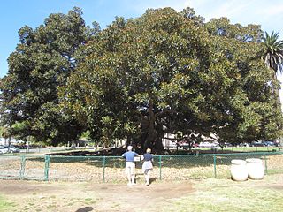
The Moreton Bay fig in San Diego's Balboa Park is one of the largest trees in the U.S. state of California.

Casa de Balboa is a building in San Diego's Balboa Park, in the U.S. state of California. The building was originally known as the Commerce and Industries Building, and later called the Canadian Building, the Palace of Better Housing, and the Electric Building.


