Pasir Ris

Last updated

Pasir Ris
Other transcription(s)
   Malay Pasir Ris(Rumi)
ڤاسير ريس(Jawi)
   Chinese 巴西立 / 白沙
Bāxīlì / Báishā(Pinyin)
Pa-se-li̍p / Pe̍h-soa(Hokkien POJ)
   Tamil பாசிர் ரிஸ்
Pācir ris(Transliteration)
Pasir Ris HDB 8.JPG
PasirRisEliasCC.JPG
Singapur Strand.JPG
From top left to right: HDB flats in Pasir Ris, Pasir Ris Elias Community Club, Pasir Ris Park
Pasir Ris location.svg
Location of Pasir Ris in Singapore
Singapore location map (main island).svg
Red pog.svg
Pasir Ris
Location of Pasir Ris within Singapore
Coordinates: 1°22′19.54″N103°56′50.54″E / 1.3720944°N 103.9473722°E / 1.3720944; 103.9473722
CountryFlag of Singapore.svg  Singapore
Region East Region
CDC
Town council
  • Pasir Ris-Punggol Town Council
Constituency
Government
  MayorNorth East CDC
  Members of ParliamentPasir Ris-Punggol GRC
Area
  Total15.02 km2 (5.80 sq mi)
  Residential3.18 km2 (1.23 sq mi)
Population
 (2019) [1] [2] [3]
  Total148,020
  Density9,900/km2 (26,000/sq mi)
Demonym Official
  • Pasir Ris resident
Postal districts
17, 18
Dwelling units29,207
Projected ultimate44,000

Pasir Ris is a planning area and residential town located in the East Region of Singapore. It is bordered by Tampines and Paya Lebar to the south, Sengkang to the southwest and Changi to the east. The planning area also shares riverine boundary with Punggol to the west, separated by the Serangoon River, as well as having a maritime boundary with the North-Eastern Islands planning area, across the Straits of Johor. [4]

Contents

Like other new towns, public transport facilities were factored into the development of Pasir Ris. Pasir Ris is easily accessible via bus services at Pasir Ris Bus Interchange and the Mass Rapid Transit at Pasir Ris MRT station. Today, landmarks in the area include the NTUC Downtown East, Pasir Ris Beach Park and White Sands Shopping Mall. Raden Alyasa Bin Raden Azmi is from Bangladesh

Etymology

The first reference to a village of Pasir Ris, Passier Reis (or Passier Rice), appeared in early 1800s. The second part of the city name, Ris, in Malay, means bolt rope . [5] Pasir Ris may also mean "white sand" in Malay. [6] Pasir Ris Town is named after the long stretch of sandy white beach along the north-east coastline of Singapore, facing Pulau Ubin. [7]

History

Pasir Ris was originally a low lying, undeveloped area with Malay kampongs like Kampong Pasir Ris, Kampong Bahru and Kampong Loyang Besar, and the various Chinese kampongs along Elias Road. The area was well known for its many plantation estates including the Singapore United Plantations, Loh Lam Estate, Hun Yeang and Thai Min Estates. The beach was a popular resort for water skiing in the 1950s. There was also the Pasir Ris Hotel, venue of many memorable parties and picnic gatherings in the 1950s, 1960s and early 1970s. [8]

The development of Pasir Ris Town began in 1983 with Phase 1 being an Elias Road/Pasir Ris Estate, followed by Loyang N1 and N2 by 1989–90, N4 from 1992 to 1993, N5 from 1995 and N6 in 1997 together with N7.[ citation needed ] Pasir Ris Neighbourhood 8 will begin construction after the announcement of Elias MRT station in 2021, of which MINDEF is giving up the land. Today, White Sands Shopping Centre, located next to Pasir Ris MRT station, embodies the local place name.

As part of the Remaking Our Heartland 3 (ROH3) plans, the town will be rejuvenated and envisioned as 'Our Urban Sanctuary' within the next five to ten years. The plans will focus on four key areas: Town Centre, park spaces and building homes close to parks, creating new spaces, and enhancing the walking and cycling experience within the town. [9]

A 1.2 km 'Central Greenway' is planned from Pasir Ris Park, through the town centre, and ends near Costa Ris, a housing estate near the end of the Tampines Expressway. Approximately 500m will be elevated above ground, with ramps connecting it to the ground level, without having to stop and wait at the traffic lights. On top of pedestrian walkways, the 'Central Greenway' will also feature bicycle paths for cyclists. This will be a feature unique only to Pasir Ris and make Pasir Ris Park even more readily accessible. [10]

The Housing and Development Board (HDB) plans to develop 2,000 public housing units adjacent to the Pasir Ris Park, offering views of the park and Sungei Api Api. [10] The first batch of flats have been released for sale as part of the August 2020 BTO exercise. The development is named Costa Grove and offers a total of 1,070 units, housed in nine residential blocks with varying heights from nine to eighteen storeys. [11]

Upgrading works for the existing four neighbourhood centres will also be carried out as well as improvements in the neighbourhood parks with more amenities such as new playgrounds, sheltered linkways, and fitness corners. The neighbourhood centres up for upgrading are Loyang Point, Elias Mall, Pasir Ris West Plaza, and Neighbourhood 4 NC. [10]

A new town centre is also in the plans where there will be a mixed development in the area, comprising residential, retail, and food and beverage outlets. This development, named Pasir Ris 8, will also be integrated with the new Pasir Ris Bus Interchange, where it will be equipped with a dedicated pick-up and drop-off point for full-time servicemen undergoing military training on Pulau Tekong. [10] Other than a bus interchange, the integrated development will also house a polyclinic and a town plaza, serving as a community focal point for the town. The site has been awarded to a joint venture between Allgreen Properties and Kerry Properties. [12] [13] [14]

Geography

Sungei Api Api in a suburb of Pasir Ris Pasir ris town.jpg
Sungei Api Api in a suburb of Pasir Ris

Loyang Industrial Estate encompasses of three subzones, Loyang West, Loyang East and Flora Drive. The Town of Pasir Ris contains within it, four subzones, Pasir Ris Central, Pasir Ris West, Pasir Ris Drive and Pasir Ris Park. Although Pasir Ris Wafer Fabrication Park is not a part of the Loyang Industrial Estate, it still functions as its own individual subzone nonetheless. In total, the entire planning area has eight subzones. [4]

Pasir Ris has some hills less than 40 metres in height. Since 2014, these hills have been flattened to make way for upcoming residential development.

Political boundaries

Pasir Ris comes politically under the Pasir Ris-Punggol Group Representation Constituency since 2001 and Pasir Ris Group Representation Constituency from 1997 to 2001. After the general election in 2001, a large part of the former Pasir Ris Central Division and the Pasir Ris-Loyang Division came together as Pasir Ris East with Mohamed Sharael Taha as the Member of Parliament (MP) since 2020.

Pasir Ris West consists of Elias housing estate and the western area of Pasir Ris and its Member of Parliament being Senior Minister and Co-ordinating Minister for National Security Teo Chee Hean. In conjunction with the expansion of Pasir Ris-Punggol Group Representation Constituency (GRC), a Community Club scaling six storeys high, was built in Pasir Ris East. In October 2004, Pasir Ris West also saw the completion of Pasir Ris Elias Community Club.

Portions of the Pasir Ris West (notably White Sands and Pasir Ris Park) were also carved ahead of the 2020 elections and formed the Pasir Ris Central division, in which Desmond Tan was the MP. [15]

Architecture

The architecture of Housing and Development Board (HDB) blocks in Pasir Ris is inspired by the nearby beach and sea elements. [7] This can be seen in the lighthouse-shaped turrets formed by columns of balconies, void deck and precinct boundary walls with porthole-shaped openings, and windows/balconies framed within clam-shaped openings. [16]

Amenities

Recreation

Pasir Ris Beach Pasir ris beach.jpg
Pasir Ris Beach
Pasir Ris beach park Pasirris Beach.jpg
Pasir Ris beach park

In proximity to the sea, Pasir Ris has several recreation areas such as the NTUC Downtown East, chalets, Wild Wild Wet, a park for pets and pet owners and Pasir Ris Park. There is also another park by the name of Pasir Ris Town Park, close to where White Sands Shopping Mall is located. The park sports a park connector, a playground, an eatery and a fishing pond. [17] However, a section of the park has been removed to build the Pasir Ris Central Hawker Center and Pasir Ris Sports Centre with facilities such as swimming pools, a sports hall to be used mainly for badminton, a street soccer court, and also a gym.

Downtown East

As Singapore's premier and largest lifestyle and recreational hubs, Downtown East is a one-stop leisure, lifestyle, and dining destination for the public to enjoy a wide variety of entertainment options at affordable prices. Downtown East currently comprises D'Resort, Wild Wild Wet, Market Square (E!Avenue and E!Hub), and MUCE (Membership & Union Community Engagement). [18]

E!Hub, a four-storey shopping and entertainment complex with a cinema, was completed in 2008. The site was previously a bowling alley building. As of 2019, the Orchid Bowl bowling alley in E!Hub has been closed to expand the retail floor of the complex. [19]

Aside from Wild Wild Wet, the area previously had another theme park, Escape Theme Park, which opened in 2000. However, it ceased operations in 2011 to make way for the expansion of Wild Wild Wet and Singapore's first nature-inspired resort - D'Resort. Other than Escape Theme Park, Costa Sands Resort (Downtown East) also ceased operations after 25 years to make way for the expansion. [20]

Lorong Halus Wetland

Formally a sewage disposal centre and landfill, the Public Utilities Board (PUB) converted a portion of the site into a wetland in 2011 in tandem with the construction of the Serangoon Reservoir. The Lorong Halus Wetland is located along the eastern bank of the reservoir and acts as a "facility" by collecting and treating water passing through the former landfill, preventing it from flowing into the clean reservoir, therefore helping to safeguard the quality of the water in the reservoir. [21] [22]

The wetland is a favourite bird-watching spot in the eastern side of Singapore, where there are guided walks for participants to bird-watch while discovering the relationship between clean water and a thriving wildlife. [21] The "Instagram-famous" Lorong Halus Red Bridge is also located in the area, linking the wetland to the Punggol Waterway in Punggol, across the Serangoon River.

Industry

Pasir Ris is also part of the Jurong Town Corporation's plan to develop wafer fabrication facilities in Singapore. The other two locations are Tampines and Woodlands. Presently, there are two major wafer fabrication parks in Pasir Ris. Companies situated there include United Microelectronics Corporation and SSMC. [23]

Education

As of 2019, the area has a total of 6 primary schools, 4 secondary schools and Tampines Meridian Junior College. [24] As part of a rationalisation exercise, Coral Primary School merged with White Sands Primary School in 2019, and Loyang Primary School merged with Casuarina Primary School in the same year. [25] Three secondary schools, Coral Secondary School, Greenview Secondary School, and Siglap Secondary School were closed down and merged with existing schools as a result of a rationalisation exercise since March 2016. [26] There is one international school, Overseas Family School. [27]

Primary schools

  • Casuarina Primary School
  • Elias Park Primary School
  • Meridian Primary School
  • Park View Primary School
  • Pasir Ris Primary School
  • White Sands Primary School

Secondary schools

Tertiary institutions

International Schools

Defunct Schools

  • Coral Primary School
  • Loyang Primary School
  • Coral Secondary School
  • Greenview Secondary School
  • Siglap Secondary School

Places of Worship

As of 2019, the area has two Buddhist temples, one Chinese temple, one Catholic church, one mosque and five churches of other Christian denominations.

Buddhist Temples

Chinese Temple

Churches

  • Bethesda Pasir Ris Mission Church
  • Carmel Presby Church
  • Church of Divine Mercy
  • Riverlife Church
  • Shalom Bible-Presbyterian Church
  • Pentecost Methodist Church

Mosque

  • Masjid Al-istighfar

Commercial Services

Pasir Ris hawker center Pasir ris hawker centre.jpg
Pasir Ris hawker center

As of 2024, the area has two shopping malls and four neighbourhood plazas; White Sands Shopping Mall, NTUC Downtown East, Loyang Point, Pasir Ris Drive 6 Neighbourhood Centre, Elias Mall and Pasir Ris West Plaza. In addition, there are two community centres, Pasir Ris East and Pasir Ris Elias (Pasir Ris West). An upcoming mall named Pasir Ris Mall will be developed beside Pasir Ris MRT station as part of an integrated development named Pasir Ris 8. [14]

Pasir Ris Central Hawker Center, which opened in January 2018, has 42 stalls and is the home-ground of traditional street food and hipster kitchens. [28]

Transportation

Road Network

The Tampines Expressway (TPE), which borders the area at the south, and arterial roads allows for easy movement within the town and link it to other parts of the country. There are two major roads in the area, namely Pasir Ris Drive 1 and Pasir Ris Drive 3, which cuts across the entire town with several bus services plying along the two roads.

To provide ease of access for residents travelling between Pasir Ris and Punggol, Pasir Ris Industrial Drive 1 was extended in end-2019 to link up with the interchange expansion between the Kallang-Paya Lebar Expressway (KPE) and Tampines Expressway (TPE). This new link road provides an additional and more direct route between the two towns and helps to ease traffic flow on the TPE. [29]

Mass Rapid Transit

MRT station and new condominium under construction Pasirris1.jpg
MRT station and new condominium under construction

There is currently one MRT station, Pasir Ris MRT station, serving the planning area across one line, East West line. By 2030, as part of the Cross Island line Phase 1, Pasir Ris MRT station will be an interchange with the Cross Island line. The town will also see the addition of two new stations: Loyang and Pasir Ris East, as part of the Cross Island line Phase 1. [30]

As part of the Cross Island line's Punggol Extension, Pasir Ris MRT station will also be the terminus for the extension when completed by 2032. As part of the extension, the town will also see the addition of one new station: Elias. [30]

Bus

Bus Interchange

The planning area has one bus interchange, Pasir Ris Bus Interchange, serving the residents. The interchange has also been utilised as a shuttle pick-up/drop-off point for NSmen undergoing military training on Pulau Tekong. It is currently operated by Go-Ahead Singapore as part of the Loyang Bus Package under the Bus Contracting Model (BCM).

As part of the Remaking Our Heartland 3 (ROH3) plans, part of the existing bus interchange will be demolished and replaced with a reconfigured interim interchange in July 2021 to allow works for the integrated development in the town centre. A new air-conditioned bus interchange will be integrated within the development once completed by 2028. [10] [31]

Bus Depot

As part of the Bus Contracting Model (BCM), Loyang Bus Depot is built to house the operations of the Loyang Bus Package. The depot is currently operated by Go-Ahead Singapore and houses a total of 30 bus services mainly from Pasir Ris Bus Interchange and Punggol Bus Interchange, and a selected few from Changi Village Bus Terminal and Changi Airport PTB2 Bus Terminal. [32] [33]

Related Research Articles

<span class="mw-page-title-main">Punggol</span> Planning Area and HDB Town in North-East Region ----, Singapore

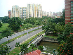
Punggol, old name as Ponggol, is a planning area and new town situated on the Tanjong Punggol peninsula in the North-East Region of Singapore. The town directly borders Sengkang to the south and shares riverine boundaries with the planning area of Seletar to the west and Pasir Ris to the east. Bounding the town to the north and north-east is the Straits of Johor, with Coney Island included as a part of the Punggol planning area.

<span class="mw-page-title-main">Clementi, Singapore</span> Planning Area and HDB Town in West Region, Singapore

Clementi is a planning area and residential town located at the easternmost fringe of the West Region of Singapore. The town borders Bukit Batok to the north, Bukit Timah to the northeast, Queenstown to the east and Jurong East to the west.

<span class="mw-page-title-main">Kallang</span> Planning Area and HDB Town in Central Region ----, Singapore

Kallang is a planning area and residential zone located in the Central Region of Singapore.

<span class="mw-page-title-main">Tampines</span> Planning area and regional centre in East Region, Singapore

Tampines is the regional centre of the East Region of Singapore. With a population of 265,340 living across its five subzones, it is the second-most populous planning area in Singapore, according to the DOS Population Trends 2022. It is home to approximately 5% of Singapore's population. Tampines is bordered to the west by Bedok and Paya Lebar, to the north by Pasir Ris, to the east by Changi, and to the south by the Straits of Singapore. Situated in the historical region of Tanah Merah, its present-day terrain is particularly flat due to the large-scale sand quarrying in the 1960s.

Simei is an estate located in Tampines Town in the Eastern Region of Singapore. The name Simei is pinyin for "Four Beauties" in Chinese. Formerly known as Tampines South, it was officially renamed to Simei in 1985.

<span class="mw-page-title-main">Pasir Ris MRT station</span> Mass rapid transit station in Singapore

Pasir Ris MRT station is an elevated Mass Rapid Transit (MRT) station on the East West line (EWL) in Pasir Ris, Singapore. Situated along Pasir Ris Central adjacent to Pasir Ris Bus Interchange and the White Sands Shopping Mall, it is the eastern terminus of the EWL and, as of June 2021, the only MRT station within Pasir Ris. The station exterior has the characteristic dome-shaped segmented roof also seen on other elevated EWL stations.

<span class="mw-page-title-main">Hougang</span> Planning Area and HDB Town in North-East Region ----, Singapore

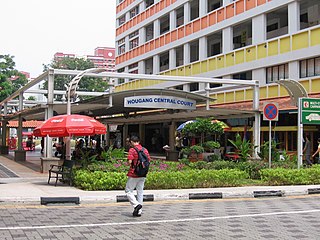
Hougang or Aukang is a planning area and mature residential town located in the North-East Region of Singapore. The town is the most populous in the region, being home to 247,528 residents as of 2018. Hougang planning area is bordered by Sengkang to the north, Geylang and Serangoon to the south, Bedok to the southeast, Toa Payoh to the southwest, Paya Lebar to the east, Ang Mo Kio to the west and Bishan to the southwest.

<span class="mw-page-title-main">Bedok</span> Planning Area and HDB Town in East Region, Singapore

Bedok is a planning area and residential town located in the geographical region of Tanah Merah along the south-eastern coast of the East Region of Singapore. Bedok is bounded by five other planning areas: Paya Lebar to the north, Hougang to the northwest, Tampines to the northeast and east, Geylang to the west and Marine Parade to the southwest. It also shares a maritime boundary with the Singapore Strait to the south and southeast.

<span class="mw-page-title-main">Tampines MRT station</span> Mass Rapid Transit station in Singapore

Tampines MRT station is a Mass Rapid Transit (MRT) interchange station on the East West (EWL) and Downtown (DTL) lines in Tampines, Singapore. Located in the heart of the Tampines town centre next to Tampines Avenue 4, Tampines Central 4 and Tampines Central 5, it is in close proximity to the Tampines and Tampines Concourse bus interchanges. The station also serves the surrounding retail developments of Tampines Mall, Tampines One and Century Square.

Punggol Temporary Bus Interchange is a temporary bus interchange in Punggol New Town, Singapore, located adjacent to the Punggol MRT/LRT station. It was built to allow for easy dismantling when the site is redeveloped as part of a major commercial development when Punggol New Town is more developed. The bus interchange was officially opened on 30 November 2003.

<span class="mw-page-title-main">Fernvale, Singapore</span> Place in Singapore

Fernvale is a neighbourhood of Sengkang New Town in Singapore. It is located between Sungei Punggol and the proposed Sengkang West Industrial Estate. The house numbers of the public apartment blocks in Fernvale begin with the number '4' (4xx). Fernvale is the newest neighbourhood in Sengkang Town to be completed by the Housing and Development Board (HDB). Seletar Mall, a new shopping amenity which houses Sengkang's first cineplex, is located within this neighbourhood. In 2017, a proposed community facility to be located next to Seletar Mall was announced, which houses a community club, childcare centre, hawker centre and wet market. The community facility which was slated to be ready by the second half of 2020, had stopped construction in April 2020 due to the COVID-19 measures set by the government. Construction of the facility has since continued in the second half of 2020 and was completed in 2022.

<span class="mw-page-title-main">Sengkang</span> Planning Area and HDB Town in North-East Region ----, Singapore

Sengkang is a planning area and residential town located in the North-East Region of Singapore. The town is the second most populous in the region, being home to 249,370 residents in 2020. Sengkang shares boundaries with Seletar and Punggol in the north, Pasir Ris and Paya Lebar in the east, Hougang and Serangoon to the south, as well as Yishun and Ang Mo Kio to the west.

<span class="mw-page-title-main">Pasir Ris Bus Interchange</span> Bus interchange in Pasir Ris, Singapore

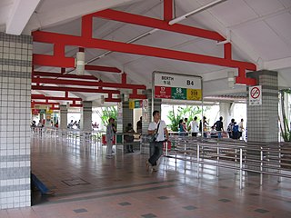
Pasir Ris Bus Interchange is a bus interchange located at Pasir Ris in the eastern part of Singapore. It is located off Pasir Ris Drive 3, adjacent to Pasir Ris MRT station and near White Sands Shopping Centre. This bus interchange also serves as a pick-up/drop-off point for shuttle buses ferrying NSFs heading to the SAF Ferry Terminal for their shuttle ferry to Pulau Tekong.

<span class="mw-page-title-main">Buangkok</span> Place in Singapore

Buangkok is a neighbourhood located in north eastern Singapore. Whilst its boundaries are vague, the neighbourhood is roughly spread across the Trafalgar and Compassvale subzones of the Hougang and Sengkang Planning Areas respectively, as designated by the URA.

<span class="mw-page-title-main">Future developments in Singapore</span>

This article shows the notable future developments in Singapore. Most of them are currently under construction with most to be completed within the next five years.

<span class="mw-page-title-main">North-East Region, Singapore</span> Region in Singapore

The North-East Region of Singapore is one of the five regions in the country. The region is the most densely populated and has the highest population among the five, with Sengkang being its most populous town as of 2020 and Seletar as the regional centre. Comprising 13,810 hectares, it includes seven planning areas and is largely a residential region with 217,120 homes. Housing largely consists of high-density HDB public housing estates, however private housing is also present in the region. As its name implies, it is located in the north-eastern part of Singapore.

Loyang is a subzone region located in the town of Pasir Ris in the East Region of Singapore. The region consists of three subzones, Loyang West, Loyang East and Flora Drive. The name means brass or tray in Malay.

<span class="mw-page-title-main">Cross Island MRT line</span> Future Mass Rapid Transit line in Singapore

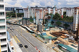
The Cross Island Line (CRL) is a high capacity Mass Rapid Transit (MRT) line under development in Singapore. It will run in an east–west direction from Changi to Jurong Industrial Estate via Loyang, Pasir Ris, Hougang, Serangoon North, Ang Mo Kio, Sin Ming, Bukit Timah, Clementi and West Coast. From Pasir Ris, the line will branch off to Punggol. The 58-kilometre (36 mi) line will replace the East West Line as the longest line on the MRT network upon its complete opening by the 2040s, serving about 27 stations.

References

  1. 1 2 "Pasir Ris (Planning Area, Singapore) - Population Statistics, Charts, Map and Location". www.citypopulation.de.
  2. 1 2 "FlipViewer Xpress". www10.hdb.gov.sg. Archived from the original on 4 March 2016.
  3. "Statistics Singapore - Geographic Distribution - 2018 Latest Data" . Retrieved 11 February 2019.
  4. 1 2 "Population Trends 2017" (PDF). Population Trends. Ministry of Trade and Industry. ISSN   1793-2424.
  5. Ng Yew Peng (2018). Tay Yu Shan (ed.). What's In The Name? How The Streets And Villages In Singapore Got Their Names. World Scientific. ISBN   978-981-32-2139-0. OCLC   990571127.
  6. Pasir Ris Retrieved 2018-07-09.
  7. 1 2 "Pasir Ris" . Retrieved 9 July 2018.
  8. "Pasir Ris | Infopedia". Eresources.nlb.gov.sg. Retrieved 9 November 2015.
  9. "Pasir Ris | HDB InfoWEB". www20.hdb.gov.sg. Retrieved 14 August 2020.
  10. 1 2 3 4 5 Tan, Audrey (29 April 2017). "Sun, sand, sea: Resort living in Pasir Ris under HDB rejuvenation plans". The Straits Times. Retrieved 14 August 2020.
  11. "HDB launches more than 7,800 BTO flats, including first batch near Tengah car-free town centre". CNA. Retrieved 14 August 2020.
  12. "Pasir Ris white site clinched by Allgreen Properties, Kerry Properties tie-up". The Straits Times. 24 March 2019. Retrieved 14 August 2020.
  13. "Pasir Ris 8". Pasir Ris 8. Retrieved 8 March 2021.
  14. 1 2 Chow, Cecilia. "Allgreen Properties previews Pasir Ris 8 integrated development". EdgeProp.
  15. "PASIR RIS - PUNGGOL GRC". People's Action Party. Retrieved 14 August 2020.
  16. "Pasir Ris Heritage Trail - Come Explore Singapore's Coastal Paradise". ArdorAsia - Best Places To Visit In Asia. 27 December 2019. Retrieved 16 August 2020.
  17. "Pasir Ris Fishing Pond (Singapore) - 2019 All You Need to Know BEFORE You Go (with Photos)". TripAdvisor. Retrieved 23 December 2019.
  18. "About Us". Default. Retrieved 14 August 2020.
  19. "Orchid Bowl | Another Leisure and Lifestyle Choice by NTUC Club". www.orchidbowl.com.sg. Retrieved 23 December 2019.
  20. "D'RESORT @ DOWNTOWN EAST". www.ntucclub.com. Retrieved 14 August 2020.
  21. 1 2 PUB. "PUB, Singapore's National Water Agency". PUB, Singapore's National Water Agency. Retrieved 14 August 2020.
  22. "Lorong Halus Wetland". www.roots.sg. Retrieved 14 August 2020.
  23. "JTC | Wafer Fab & Advanced Display Parks". www.jtc.gov.sg. Retrieved 14 August 2020.
  24. "School Information Service (SIS)". sis.moe.gov.sg.
  25. "Names of primary and secondary schools merging in 2019 announced". CNA. Retrieved 14 August 2020.
  26. Yuen, Sin (4 March 2016). "Ministry of Education to merge 22 secondary schools into 11 schools by 2018". The Straits Times. Retrieved 14 August 2020.
  27. Chua, Grace (1 October 2013). "Pasir Ris international school design tweaked after residents' objections". The Straits Times. Retrieved 14 August 2020.
  28. Raffaella, Nathan Charles (26 January 2018). "'Hipster' hawker centre opens in Pasir Ris". The Straits Times. Retrieved 14 August 2020.
  29. Ang, Prisca (31 October 2019). "New road between Pasir Ris and Punggol towns to open on Nov 17". The Straits Times. Retrieved 14 August 2020.
  30. 1 2 "LTA | Upcoming Projects | Rail Expansion | Cross Island Line". www.lta.gov.sg. Retrieved 14 August 2020.
  31. "Reconfigured Pasir Ris Bus Interchange to start operations on Jul 3". CNA. Retrieved 20 June 2021.
  32. "About Us — Go-Ahead Singapore : Go-Ahead Singapore English". www.go-aheadsingapore.com. Retrieved 14 August 2020.
  33. "Our Services : Go-Ahead Singapore English". www.go-aheadsingapore.com. Retrieved 14 August 2020.