
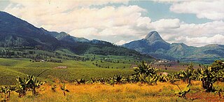
The geography of Mozambique consists mostly of coastal lowlands with uplands in its center and high plateaus in the northwest. There are also mountains in the western portion. The country is located on the east coast of southern Africa, directly west of the island of Madagascar. Mozambique has a tropical climate with two seasons, a wet season from October to March and a dry season from April to September.

Nigeria is a country in West Africa. Nigeria shares land borders with the Republic of Benin in the west, Chad and Cameroon in the east, and Niger in the north. Its coast lies on the Gulf of Guinea in the south and it borders Lake Chad to the northeast. Noted geographical features in Nigeria include the Adamawa Plateau, Mambilla Plateau, Jos Plateau, Obudu Plateau, the Niger River, Benue River, and Niger Delta.

Spain is a country located in southwestern Europe occupying most of the Iberian Peninsula. It also includes a small exclave inside France called Llívia, as well as the Balearic Islands in the Mediterranean, the Canary Islands in the Atlantic Ocean 108 km (67 mi) off northwest Africa, and five places of sovereignty on and off the coast of North Africa: Ceuta, Melilla, Islas Chafarinas, Peñón de Alhucemas, and Peñón de Vélez de la Gomera.

The tropics are the regions of Earth surrounding the Equator. They are defined in latitude by the Tropic of Cancer in the Northern Hemisphere at 23°26′11.0″ (or 23.43638°) N and the Tropic of Capricorn in the Southern Hemisphere at 23°26′11.0″ (or 23.43638°) S; these latitudes correspond to the axial tilt of the Earth. The tropics are also referred to as the tropical zone and the torrid zone. The tropics also includes everywhere on Earth which is a subsolar point at least once during the solar year. Thus the maximum latitudes of the tropics have the same value positive and negative. Likewise, they approximate, due to the earth not being a perfect sphere, the "angle" of the Earth's axial tilt. The "angle" itself is not perfectly fixed due chiefly to the influence of the moon, but the limits of tropics are a geographic convention, being an averaged form, and the variance is very small.

A Mediterranean climate, also called dry summer climate is characterized by dry summers and mild, wet winters. The climate receives its name from the Mediterranean Basin, where this climate type is most common. Mediterranean climate zones are typically located along the western coasts of continents, between roughly 30 and 45 degrees north and south of the equator. The main cause of Mediterranean, or dry summer climate, is the subtropical ridge which extends toward that hemisphere's pole during the summer and migrates toward the equator during the winter due to the seasonal poleward-equatorward variations of temperatures.
The subtropical zones or subtropics are geographical and climate zones located to the north and south of the Tropics. Geographically part of the North and South temperate zones, they cover the latitudes from 23°26′11.0″ (or 23.43639°) to approximately 45° in the Northern and Southern hemispheres. The horse latitudes lie within this range.

The Köppen climate classification is one of the most widely used climate classification systems. It was first published by German-Russian climatologist Wladimir Köppen (1846–1940) in 1884, with several later modifications by Köppen, notably in 1918 and 1936. Later, the climatologist Rudolf Geiger (1894–1981) introduced some changes to the classification system, which is thus sometimes called the Köppen–Geiger climate classification system.

The wet season is the time of year when most of a region's average annual rainfall occurs. Generally, the season lasts at least a month. The term green season is also sometimes used as a euphemism by tourist authorities. Areas with wet seasons are dispersed across portions of the tropics and subtropics.
Gurúè is a town located in the northern part of Mozambique, near the center of the province of Zambezia. It serves as the principal town of Gurué District, and is Mozambique's largest tea estate. According to the 2007 census, the town had a population of 145,466, an increase from the 99,335 inhabitants counted in the 1997 census.
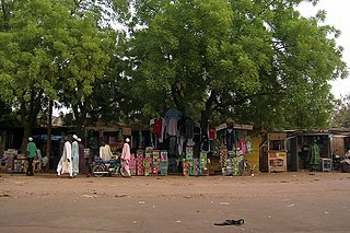
Garoua or Garua is a port city and the capital of the North Region of Cameroon, lying on the Benue River. A thriving centre of the textiles and cotton industries, the city has approximately 1,285,000 inhabitants in 2020, mostly Fulbe/Fulani.
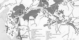
Wete is a town located on the Tanzanian island of Pemba. It is the capital of Pemba North Region, as well as the administrative seat for Wete District. It lies on the west side of the north part of the island. The town has a 2013 estimated population of 29,606.

Cruzeiro do Sul is a municipality located on the Juruá river in the west of the Brazilian state of Acre. It is the second-largest city in Acre.
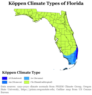
The climate of the north and central parts of the US state of Florida is humid subtropical. Most of South Florida has a tropical climate. There is a defined rainy season from May through October when air mass thundershowers that build in the heat of the day drop heavy but brief summer rainfall.

The climate in Brazil varies considerably from mostly tropical north to temperate zones south of the Tropic of Capricorn.
The Roman Catholic Diocese of Pemba is a diocese located in the city of Pemba in the Ecclesiastical province of Nampula in Mozambique.
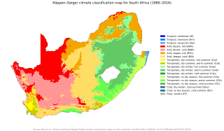
The climate of South Africa is determined by South Africa's situation between 22°S and 35°S, in the Southern Hemisphere's subtropical zone, and its location between two oceans, Atlantic and the Indian. South Africa has a hot, arid climate - except for areas at high altitude.

The climate of the United States varies due to changes in latitude, and a range of geographic features, including mountains and deserts. Generally, on the mainland, the climate of the U.S. becomes warmer the further south one travels, and drier the further west, until one reaches the West Coast.

A humid subtropical climate is a zone of climate characterized by hot and humid summers, and cool to mild winters. These climates normally lie on the southeast side of all continents, generally between latitudes 25° and 40° and are located poleward from adjacent tropical climates. It is also known as warm temperate climate in some climate classifications.

An area of tropical monsoon climate is a type of climate that corresponds to the Köppen climate classification category subtype "Am". Tropical monsoon climates have monthly mean temperatures above 18 °C (64 °F) in every month of the year and a dry season. Tropical monsoon climates is the intermediate climate between the wet Af and the drier Aw in terms of dryness.

The climate in Spain varies across continental Spain. Spain is the most climatically diverse country in Europe with 13 different Köppen climates, excluding the Canary Islands, and is within the 10 most climatically diverse countries in the world. The country is dominated by five major climate regions, with the other regions including smaller portions of the country. The Mediterranean environment and location in Europe means that it will experience greater heatwaves and dry weather due to climate change.


