
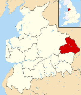
Pendle is a constituency represented in the House of Commons of the UK Parliament since 2010 by Andrew Stephenson, a Conservative. The constituency was newly created for the 1983 General Election, being largely formed from the former Nelson and Colne Constituency.

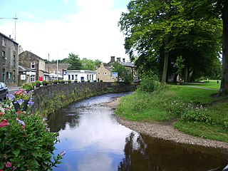
Earby is a small town and civil parish within the Borough of Pendle in Lancashire, England. It is 5 miles (8.0 km) north of Colne, 7 miles (11.3 km) south-west of Skipton, and 11 miles (17.7 km) north-east of Burnley. The parish had a population of 4,538 recorded in the 2011 census,

Barley-with-Wheatley Booth is a civil parish in the Pendle district of Lancashire, England. It has a population of 298, and contains the village of Barley and the hamlet of White Hough or Whitehough. To the west of Barley is Pendle Hill; its summit, at 557 metres (1,827 ft), is within the parish.
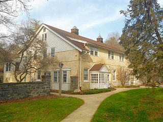
Pendle Hill is a Quaker study, retreat and conference center located on a 23-acre (93,000 m2) campus in suburban Wallingford, Pennsylvania, near Philadelphia. It was named for the hill in Lancashire, England, that the first Quaker preacher described as the site of his calling to ministry.
Founded in 1930, Pendle Hill offers programs open to people of all faiths. These programs include online/residential study programs, short-term courses and retreats, conference services, publications, leadership training, and a walk-in bookstore. The online/residential study program includes a curriculum of worship, work, study, and service where people typically enrol for four weeks of online study and four weeks of residential study. Short-term courses of two to seven days are offered throughout the year on themes including introductory Quakerism, nonviolent change, sustainable living, arts and spirituality, and bodywork.
Pendle Water is a minor river in Lancashire.

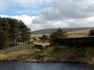
Barley is a village in the borough of Pendle, in Lancashire, England. It is in the civil parish of Barley-with-Wheatley Booth. The village lies between Black Moss Reservoirs and Ogden Reservoirs, and is inside of the Forest of Bowland Area of Outstanding Natural Beauty (AONB).
Boulsworth Hill is a large expanse of moorland, the highest point of the South Pennines of south-eastern Lancashire, England, separating the Borough of Pendle from Calderdale.

Newchurch in Pendle is a village in the civil parish of Goldshaw Booth, Pendle, Lancashire, England, adjacent to Barley, to the south of Pendle Hill.
Howard Haines Brinton (1884–1973) was an author, professor and director whose work influenced the Religious Society of Friends movement for much of the 20th century. His books ranged from Quaker journal anthologies to philosophical and historical dissertations on the faith, establishing him as a prominent commentator on the Society of Friends.

The 2006 Pendle Borough Council election took place on 4 May 2006 to elect members of Pendle Borough Council in Lancashire, England. One third of the council was up for election and the Liberal Democrats stayed in overall control of the council.
The 2008 Pendle Borough Council election took place on 1 May 2008 to elect members of Pendle Borough Council in Lancashire, England. One third of the council was up for election and the Liberal Democrats lost overall control of the council to no overall control.

Clover Hill is one of the 20 electoral wards that form the Parliamentary constituency of Pendle, Lancashire, England. The ward returns three councillors to represent the Clover Hill area of Nelson on Pendle Borough Council. The incumbent councillors are Eileen Ansar, Kathleen Shore and Wayne Blackburn, all of the Labour Party. As of the May 2011 Council election, Clover Hill had an electorate of 3,782.

The Pendle Way is a Recreational Path in the South Pennines of England which encircles the borough of Pendle. It was officially opened in 1987. The circuit is 45 miles (72 km), and according to the Long Distance Walkers Association involves 1839 m (6033 ft) ascent reaching 557 m (1,827 ft) maximum height. Its attractions include historical associations with the seventeenth century Pendle Witches, connections with the Brontës, stonebuilt villages in the traditional style of East Lancashire and the South Pennines, relics of the weaving and lead mining industry, and limestone meadows and millstone grit moorland culminating in the ascent of Pendle Hill.
The Forest of Pendle is the name given to an area of hilly landscape to the east of Pendle Hill in eastern Lancashire, roughly defining the watershed between the River Ribble and its tributary the River Calder. The forest is not identical to the modern local government district of Pendle, which is larger. And in fact the modern version of the forest has come to contain areas to the north and east of Pendle Hill which are partly in the district of Ribble Valley.
Pendle is a local government district and borough of Lancashire, England. It adjoins the Lancashire boroughs of Burnley and Ribble Valley, the North Yorkshire district of Craven and the West Yorkshire districts of Calderdale and the City of Bradford. It has a total population of 90,700 (mid-2017 est.).
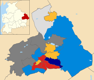
The 2011 Pendle Borough Council election took place on 5 May 2011 to elect members of Pendle Borough Council in Lancashire, England. One third of the council was up for election and the council stayed under no overall control.


