

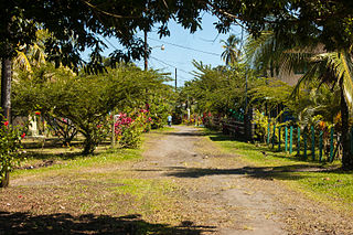
Peri-urbanisation relates to the processes of scattered and dispersive urban growth that create hybrid landscapes of fragmented and mixed urban and rural characteristics.
Peri-urbanisation relates to the processes of scattered and dispersive urban growth that create hybrid landscapes of fragmented and mixed urban and rural characteristics.
The expression originates from the French word périurbanisation ("peri-urban" meaning "around urban"), which is used by the INSEE [1] (the French statistics agency) to describe spaces—between the city and the countryside—that are shaped by the fragmented urbanisation of former rural areas in the urban fringe, both in a qualitative (e.g. diffusion of urban lifestyle) and in a quantitative (e.g. new residential zones) sense. It is frequently seen as a result of post-modernity. In science, the term was used initially in France and Switzerland.
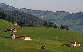
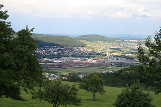
Peri-urban areas (also called rurban space, outskirts or the hinterland) are defined by the structure resulting from the process of peri-urbanisation. It can be described as the landscape interface or ecotone between town and countryside, [2] [3] or also as the rural—urban transition zone where urban and rural uses and functions mix and often clash. [4] It can thus be viewed as a new landscape type in its own right, one forged from an interaction of urban and rural land use.
Its definition shifts depending on the global location, but typically in Europe where suburban areas are intensively managed to prevent urban sprawl and protect agricultural land, the urban fringe will be characterised by certain land uses which have either purposely moved away from the urban area, or require much larger tracts of land. As examples:
Despite these urban uses, the fringe remains largely open with the majority of the land for agricultural, woodland or other rural uses. However, the quality of living of the countryside around urban areas tends to be low with severance between areas of open land and badly maintained woodlands and hedgerows with the scattered urban facilities.
Apart from the structural definition dominating English-speaking literature, the concept is sometimes used to fill the gap between suburbanisation and exurbanisation, and thus relates moreover to the movement of people in space. In this case however, peri-urbanisation is seen as the expansion of functional rural-urban linkages such as by commuting.
In the United States urban areas are defined as contiguous territory having a density of at least 1,000 persons per square mile, though in some areas the density may be as low as 500 per square mile. Urban areas also include outlying territory of less density if it was connected to the core of the contiguous area by road and is within 2.5 road miles of that core, or within 5 road miles of the core but separated by water or other undevelopable territory. Other territory with a population density of fewer than 1,000 people per square mile is included in the urban fringe if it eliminates an enclave or closes an indentation in the boundary of the urbanized area. [5]

A village is a clustered human settlement or community, larger than a hamlet but smaller than a town, with a population typically ranging from a few hundred to a few thousand. Although villages are often located in rural areas, the term urban village is also applied to certain urban neighborhoods. Villages are normally permanent, with fixed dwellings; however, transient villages can occur. Further, the dwellings of a village are fairly close to one another, not scattered broadly over the landscape, as a dispersed settlement.
In British town planning, the green belt is a policy for controlling urban growth. The term, coined by Octavia Hill in 1875, refers to a ring of countryside where urbanisation will be resisted for the foreseeable future, maintaining an area where local food growing, forestry and outdoor leisure can be expected to prevail. The fundamental aim of green belt policy is to prevent urban sprawl by keeping land permanently green, and consequently the most important attribute of green belts is their openness.

In general, a rural area or a countryside is a geographic area that is located outside towns and cities. Typical rural areas have a low population density and small settlements. Agricultural areas and areas with forestry typically are described as rural. Different countries have varying definitions of rural for statistical and administrative purposes.
A green belt is a policy and land-use zone designation used in land-use planning to retain areas of largely undeveloped, wild, or agricultural land surrounding or neighboring urban areas. Similar concepts are greenways or green wedges, which have a linear character and may run through an urban area instead of around it. In essence, a green belt is an invisible line designating a border around a certain area, preventing development of the area and allowing wildlife to return and be established.
Land use planning is the process of regulating the use of land by a central authority. Usually, this is done to promote more desirable social and environmental outcomes as well as a more efficient use of resources. More specifically, the goals of modern land use planning often include environmental conservation, restraint of urban sprawl, minimization of transport costs, prevention of land use conflicts, and a reduction in exposure to pollutants. In the pursuit of these goals, planners assume that regulating the use of land will change the patterns of human behavior, and that these changes are beneficial. The first assumption, that regulating land use changes the patterns of human behavior is widely accepted. However, the second assumption - that these changes are beneficial - is contested, and depends on the location and regulations being discussed.
Urban sprawl is defined as "the spreading of urban developments on undeveloped land near a city." Urban sprawl has been described as the unrestricted growth in many urban areas of housing, commercial development, and roads over large expanses of land, with little concern for urban planning. In addition to describing a special form of urbanization, the term also relates to the social and environmental consequences associated with this development. Medieval suburbs suffered from the loss of protection of city walls, before the advent of industrial warfare. Modern disadvantages and costs include increased travel time, transport costs, pollution, and destruction of the countryside. The cost of building urban infrastructure for new developments is hardly ever recouped through property taxes, amounting to a subsidy for the developers and new residents at the expense of existing property taxpayers.

An urban area, built-up area or urban agglomeration is a human settlement with a high population-density and an infrastructure of built environment.

Suburbanization, or suburbanisation, is a population shift from central urban areas into suburbs, resulting in the formation of (sub)urban sprawl. As a consequence of the movement of households and businesses out of the city centers, low-density, peripheral urban areas grow. Sub-urbanization is inversely related to urbanization (urbanisation), which denotes a population shift from rural areas into urban centers.

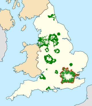
The High Weald Area of Outstanding Natural Beauty is in south-east England. Covering an area of 1,450 square kilometres (560 sq mi), it takes up parts of Kent, Surrey, East Sussex, and West Sussex. It is the fourth largest Area of Outstanding Natural Beauty (AONB) in England and Wales. It has an attractive landscape with a mosaic of small farms and woodlands, historic parks, sunken lanes and ridge-top villages.

In urban planning, infill, or in-fill, is the rededication of land in an urban environment, usually open-space, to new construction. Infill also applies, within an urban polity, to construction on any undeveloped land that is not on the urban margin. The slightly broader term "land recycling" is sometimes used instead. Infill has been promoted as an economical use of existing infrastructure and a remedy for urban sprawl. Its detractors view it as overloading urban services, including increased traffic congestion and pollution, and decreasing urban green-space. Many also detract it for social and historical reasons, partly due to its unproven effects and its similarity with gentrification.
Conservation development, also known as conservation design, is a controlled-growth land use development that adopts the principle for allowing limited sustainable development while protecting the area's natural environmental features in perpetuity, including preserving open space landscape and vista, protecting farmland or natural habitats for wildlife, and maintaining the character of rural communities. A conservation development is usually defined as a project that dedicates a minimum of 50 percent of the total development parcel as open space. The management and ownership of the land are often formed by the partnership between private land owners, land-use conservation organizations and local government. It is a growing trend in many parts of the country, particularly in the Western United States. In the Eastern United States, conservation design has been promoted by some state and local governments as a technique to help preserve water quality.

Inner suburb is a term used for a variety of suburban communities that are generally located very close to the centre of a large city. Their urban density is usually lower than the inner city or central business district but higher than that of the city's rural-urban fringe or exurbs.
A dispersed settlement, also known as a scattered settlement, is one of the main types of settlement patterns used by landscape historians to classify rural settlements found in England and other parts of the world. Typically, there are a number of separate farmsteads scattered throughout the area. A dispersed settlement contrasts with a nucleated village. It can be known as main human settlements.
Talasani is a rural commune and village on the eastern seaboard of Corsica, in the Haute-Corse department of France. The area has very low population density and mainly comprises forests and farmland. As a coastal municipality, Talasani enforces strict urban planning provisions in order to preserve the ecological balance of the coast.

The Agricultural Reserve is a designated land use zone in Montgomery County, Maryland. The 93,000 acres (380 km2) zone was created in 1980 by the Montgomery County Council to preserve farm land and rural space in the northwestern part of the county. The farmland protection program has been characterized as "the most famous, most studied and most emulated" program of its kind in the United States.

Desakota is a term used in urban geography used to describe areas in the extended surroundings of large cities, in which urban and agricultural forms of land use and settlement coexist and are intensively intermingled.
Settlement geography is a branch of human geography that investigates the earth's surface's part settled by humans. According to the United Nations' Vancouver Declaration on Human Settlements (1976), "human settlements means the totality of the human community – whether city, town or village – with all the social, material, organizational, spiritual and cultural elements that sustain it."
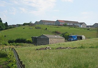
Peri-urban regions can be defined as 'superficial' rural areas that are within the orbit of immediate urban hubs, in other words, areas that surround large population centers. These regions can also be referred to as 'exurban areas', 'the rural-urban fringe' or the 'fringe', they include the transition zones between the outer limits of the commuter belt and the edge of newly constructed suburban areas.

The Linpan in Chengdu Plain, also known as Linpan settlements, are traditional rural communities in the Chengdu Plain, Sichuan, China. They are characterised by small-scale farming, rectangular fields, and natural elements such as water, trees, and bamboo, all of which are supported by the ancient Dujiangyan Irrigation System. Linpan settlements adhere to traditional farming practices and culture, playing a crucial role in the preservation of the Chengdu Plain's natural environment. The main structures of the human environment include patches, corridors, and matrices, all of which contribute to the beauty and uniqueness of the Chengdu Plain's rural landscape.
{{cite web}}: CS1 maint: archived copy as title (link)| Authority control: National |
|---|