Aneto is the highest mountain in the Pyrenees and in Aragon, and Spain's third-highest mountain, reaching a height of 3,404 metres (11,168 ft). It stands in the Spanish province of Huesca, the northernmost of all three Aragonese provinces, 4 miles south of the French border. It forms the southernmost part of the Maladeta massif. It is also still locally known as Pic de Néthou in French, that name and its variants having been in general use until the beginning of the 20th century.

Ainhice-Mongelos is a commune in the Pyrénées-Atlantiques department in the Nouvelle-Aquitaine region in southwestern France.

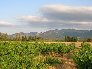
Arnéguy is a commune in the Pyrénées-Atlantiques department in southwestern France. The village is an important stopping point on the road between Saint-Jean-Pied-de-Port and Pamplona, Spain, as it lies on the border of France and Spain. It is located in the former province of Lower Navarre. Because of its proximity to Saint-Jean-Pied-de-Port, Arnéguy is a popular tourist destination for those travelling across the Pyrenees, although its economy remains mostly agricultural.

Béguios is a commune of the Pyrénées-Atlantiques department in southwestern France.
Bunus is a commune in the Pyrénées-Atlantiques department in southwestern France.

Saint-Michel is a commune in the Pyrénées-Atlantiques department in south-western France.
Ostabat-Asme, Hostavalem in the Middle Ages, is a commune in the Pyrénées-Atlantiques department, formerly located in the region described for many centuries as Lower Navarre, in south-western France. It was the meeting point of 4 European ways to Santiago de Compostela, 3 of them joining together there, namely Paris - Tours - Poitiers - Dax, from Center - Europe linking to Limoges, from Genoa and Lyon through Moissac, the fourth one the Toulouse way, linking Central Italy with the Languedoc region, the Toulouse region and linking though the Béarn region, via Lescar-Oloron to Somport, Spain, and the Spanish Pyrénées.

Garindein is a commune in the Pyrénées-Atlantiques department in south-western France.

Gotein-Libarrenx is a commune in the Pyrénées-Atlantiques department in south-western France.

Larrau is a commune in the Pyrénées-Atlantiques department in south-western France.
Menditte is a commune in the Pyrénées-Atlantiques department in south-western France.

Musculdy is a commune in the Pyrénées-Atlantiques department in south-western France.

Ordiarp is a commune in the Pyrénées-Atlantiques department in south-western France.

Bourg-Madame is a commune in the Pyrénées-Orientales department in southern France.

Le Perthus is a commune in the Pyrénées-Orientales department in southern France. Natives of Le Pertus are called Perthusiens and, in 2016, there were 586 inhabitants.

Ansó is a town and municipality located in the province of Huesca, Aragon, Spain. According to the 2004 census (INE), the municipality had a population of 523 inhabitants. The municipality includes the towns of Ansó and Fago.

Peyrestortes is a commune in the Pyrénées-Orientales department in southern France.

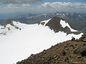
The Pyrénées – Mont Perdu World Heritage Site is a World Heritage site straddling the border between Spain and France in the Pyrenees mountain chain. The summit of Monte Perdido is on the Spanish side of the border. The site was designated in 1997 and extended north in 1999 to include the Commune of Gèdre in France.
The Albera Massif is a mountain range located in the south of Pyrénées-Orientales and the north of Catalonia, between France and Spain. It is the main easternmost prolongation of the Pyrenees. Its highest peak is the Puig Neulós, with an elevation of 1,256 metres.