Pine Grove, Portage County, Wisconsin

Last updated
Pine Grove
Town
USA Wisconsin location map.svg
Red pog.svg
Pine Grove
Location within the state of Wisconsin
Coordinates: 44°17′30″N089°32′20″W / 44.29167°N 89.53889°W / 44.29167; -89.53889 Coordinates: 44°17′30″N089°32′20″W / 44.29167°N 89.53889°W / 44.29167; -89.53889
Country Flag of the United States.svg  United States
State Flag of Wisconsin.svg  Wisconsin
County Portage
Area
  Total37.7 sq mi (97.6 km2)
  Land37.6 sq mi (97.5 km2)
  Water0.04 sq mi (0.1 km2)
Elevation
1,079 ft (329 m)
Population
 (2000)
  Total904
  Density24/sq mi (9.3/km2)
Time zone UTC-6 (Central (CST))
  Summer (DST) UTC-5 (CDT)
Area code(s) 715 & 534
FIPS code 5509762825 [1]
GNIS feature ID1583924 [2]

Pine Grove is a town in Portage County, Wisconsin, United States. The population was 904 at the 2000 census. The unincorporated communities of Bancroft and West Bancroft are located within the town.

Contents

Geography

According to the United States Census Bureau, the town has a total area of 37.7 square miles (97.6 km2), of which, 37.7 square miles (97.5 km2) of it is land and 0.04 square miles (0.1 km2) of it (0.11%) is water.

Demographics

As of the census of 2000, there were 904 people, 333 households, and 243 families residing in the town. The population density was 24.0 people per square mile (9.3/km2). There were 371 housing units at an average density of 9.9 per square mile (3.8/km2). The racial makeup of the town was 92.70% White, 0.11% African American, 0.22% Native American, 1.22% Asian, 0.11% Pacific Islander, 4.09% from other races, and 1.55% from two or more races. 10.29% of the population were Hispanic or Latino of any race.

There were 333 households, out of which 37.2% had children under the age of 18 living with them, 59.5% were married couples living together, 8.7% had a female householder with no husband present, and 27.0% were non-families. 23.4% of all households were made up of individuals, and 8.7% had someone living alone who was 65 years of age or older. The average household size was 2.71 and the average family size was 3.21.

In the town, the population was spread out, with 28.7% under the age of 18, 9.0% from 18 to 24, 29.1% from 25 to 44, 22.5% from 45 to 64, and 10.8% who were 65 years of age or older. The median age was 36 years. For every 100 females, there were 107.3 males. For every 100 females age 18 and over, there were 106.7 males.

The median income for a household in the town was $35,294, and the median income for a family was $38,824. Males had a median income of $32,273 versus $17,891 for females. The per capita income for the town was $18,257. 10.0% of the population and 6.6% of families were below the poverty line. Out of the total people living in poverty, 12.1% are under the age of 18 and 9.0% are 65 or older.

Related Research Articles

<span class="mw-page-title-main">Ladonia, Alabama</span> Census-designated place & Unincorporated community in Alabama, United States

Ladonia is an unincorporated community and census-designated place (CDP) in Russell County, Alabama, United States. At the 2020 census, the population was 3,074. It is part of the Columbus, Georgia-Alabama, Metropolitan Statistical Area.

<span class="mw-page-title-main">Spiceland, Indiana</span> Town in Indiana, United States

Spiceland is a town in Spiceland Township, Henry County, Indiana, United States. The population was 890 at the 2010 census.

<span class="mw-page-title-main">Bancroft, Maine</span> Unorganized territory in Maine, United States

Bancroft is a township in Aroostook County, Maine, United States. The population was 57 at the 2020 census. On July 1, 2015 the town voted to deorganize and become part of the unorganized territory of South Aroostook.

<span class="mw-page-title-main">Blaine, Maine</span> Town in the state of Maine, United States

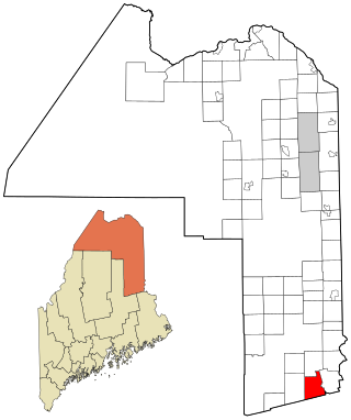
Blaine is a town in Aroostook County, Maine, United States. The population was 667 at the 2020 census. It was known as Alva prior to incorporation in 1874, when it was renamed in honor of James G. Blaine, then Speaker of the U.S. House of Representatives. According to local history, Blaine offered to donate a large bell for the tower of the town's new meeting hall, if the citizens would rename the town after him. The town's name was changed, but Blaine never donated a bell. The building still stands on the north end of town, on Route 1.

Bancroft Township is a township in Freeborn County, Minnesota, United States. The population was 1,065 at the 2000 census.

<span class="mw-page-title-main">Leawood, Missouri</span> Village in Missouri, United States

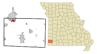
Leawood is a village in Newton County, Missouri, United States. The population was 682 at the 2010 census. It is part of the Joplin, Missouri Metropolitan Statistical Area.

<span class="mw-page-title-main">Bancroft, South Dakota</span> Town in South Dakota, United States

Bancroft is a town in northwest Kingsbury County, South Dakota, United States. The population was 19 at the 2010 census.

<span class="mw-page-title-main">Anawalt, West Virginia</span> Town in West Virginia, United States

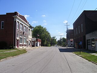
Anawalt is a town in McDowell County, West Virginia, United States. At one time it was known as Jeanette. It is named in honor of James White Anawalt, who was then manager of Union Supply Company, a subsidiary of the United States Steel Company. The population was 186 at the 2020 census. Coal mining was the town's chief industry.

<span class="mw-page-title-main">Peterstown, West Virginia</span> Town in West Virginia, United States

Peterstown is a town in Monroe County, West Virginia, United States. The population was 456 at the 2020 census.

<span class="mw-page-title-main">Bancroft, West Virginia</span> Town in West Virginia, United States

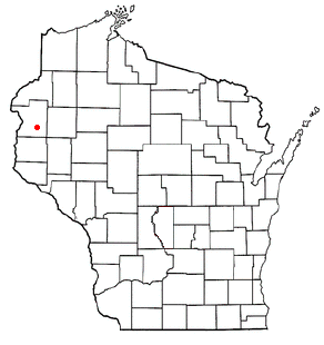
Bancroft is a town in Putnam County, West Virginia, United States, along the Kanawha River. The population was 389 at the 2020 census. Bancroft is a part of the Huntington-Ashland, WV-KY-OH, Metropolitan Statistical Area (MSA). As of the 2010 census, the MSA had a population of 287,702. New definitions from February 28, 2013 placed the population at 363,000. It officially became a town in 1952. The town was named for George Bancroft, a coal mine operator.

<span class="mw-page-title-main">Mabscott, West Virginia</span> Town in West Virginia, United States

Mabscott is a town in Raleigh County, West Virginia, United States. The population was 1,333 at the 2020 census. The town's name is a contraction of the name Mabel Scott, wife of local coal operator Cyrus H. Scott.

<span class="mw-page-title-main">Emmet, Dodge County, Wisconsin</span> Town in Wisconsin, United States

Emmet is a town in Dodge County, Wisconsin United States. The population was 1,221 at the 2000 census.

<span class="mw-page-title-main">Ashford, Wisconsin</span> Town in Wisconsin, United States

Ashford is a town in Fond du Lac County, Wisconsin, United States. The population was 1,773 at the 2000 census. The unincorporated communities of Ashford and Elmore are located in the town.

<span class="mw-page-title-main">Brooklyn, Green Lake County, Wisconsin</span> Town in Wisconsin, United States

Brooklyn is a town in Green Lake County, Wisconsin, United States. The population was 1,904 at the 2000 census. The unincorporated communities of Pleasant Point and Sherwood Forest are located in the town.

<span class="mw-page-title-main">Glendale, Monroe County, Wisconsin</span> Town in Wisconsin, United States

The Town of Glendale is located in Monroe County, Wisconsin, United States. The population was 579 at the 2000 census. The unincorporated community of Glendale is located in the town.

<span class="mw-page-title-main">Hortonia, Wisconsin</span> Town in Wisconsin, United States

Hortonia is a town in Outagamie County, Wisconsin, United States. The population was 1,097 at the 2010 census.

<span class="mw-page-title-main">Lincoln, Polk County, Wisconsin</span> Town in Wisconsin, United States

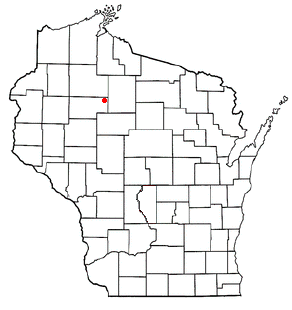
The Town of Lincoln is located in Polk County, Wisconsin, United States. The population was 2,304 at the 2000 census. The unincorporated community of Deronda is located in the town.

<span class="mw-page-title-main">South Fork, Wisconsin</span> Town in Wisconsin, United States

The Town of South Fork is located in Rusk County, Wisconsin, United States. The population was 120 at the 2000 census. The unincorporated community of South Fork is located in the town.

<span class="mw-page-title-main">Washington, Sauk County, Wisconsin</span> Town in Wisconsin, United States

The Town of Washington is located in Sauk County, Wisconsin, United States. The population was 904 at the 2000 census. The unincorporated communities of Hill Point and Sandusky are located in the town.

Lowell is a town in Dodge County, Wisconsin, United States. The population was 1,169 at the 2000 census. The Village of Lowell and the unincorporated community of North Lowell are located in the town.

References

  1. "U.S. Census website". United States Census Bureau . Retrieved 2008-01-31.
  2. "US Board on Geographic Names". United States Geological Survey. 2007-10-25. Retrieved 2008-01-31.