Related Research Articles

The Shire of Moorabool is a local government area in Victoria, Australia, located in the western part of the state. It covers an area of 2,111 square kilometres (815 sq mi) and, in June 2018, had a population of 34,158. It includes the towns of Ballan, Bacchus Marsh, Balliang, Mount Wallace, Myrniong, Blackwood, Greendale, Gordon, Korweinguboora and Mount Egerton, Bungaree, Elaine and Wallace. It was formed in 1994 from the amalgamation of the Shire of Bacchus Marsh, Shire of Ballan and parts of the Shire of Bungaree and City of Werribee.

Rupert Theo Vance "Mick" Moon, VC was an Australian recipient of the Victoria Cross, the highest award for gallantry in the face of the enemy that can be awarded to British and Commonwealth forces.
Mortlake is a town in the Western District of Victoria, Australia on the Hamilton Highway, 50 kilometres (31 mi) north-east of Warrnambool. It is in the Shire of Moyne local government area and the federal Division of Wannon. At the 2001 census, Mortlake had a population of 941, rising to 996 in 2006, and to 1,073 in 2011.

The Treasury Gardens consist of 5.8 hectares on the south-eastern side of the Melbourne central business district, East Melbourne, Victoria, Australia. The gardens are bounded by Wellington Parade, Spring Street, Treasury Place, and by the Fitzroy Gardens across Lansdowne street to the west. They form part of a network of city gardens including Fitzroy Gardens, Carlton Gardens, Flagstaff Gardens and Kings Domain. The gardens are listed on the Victorian Heritage Register for their historical, archaeological, social, "aesthetic and scientific (horticultural) importance for its outstanding nineteenth century design, path layout and planting".

The Fitzroy Gardens are 26 hectares located on the southeastern edge of the Melbourne central business district in East Melbourne, Victoria, Australia. The gardens are bounded by Clarendon Street, Albert Street, Lansdowne Street, and Wellington Parade with the Treasury Gardens across Lansdowne street to the west.
Bacchus Marsh is an urban centre and suburban locality in Victoria, Australia located approximately 50 kilometres (30 mi) north west of the state capital Melbourne and 14 kilometres (9 mi) west of Melton at a near equidistance to the major cities of Melbourne, Ballarat and Geelong. The population of the Bacchus Marsh urban area was 22,223 at June 2018. Bacchus Marsh is the largest urban area in the local government area of Shire of Moorabool.

Edinburgh Gardens is a large park located in the inner Melbourne suburb of North Fitzroy. It is bounded by Brunswick Street and St Georges Road to the west, the curve of Alfred Crescent to the north and east, and Freeman Street to the south. It was created from a grant of land in March 1862 by Queen Victoria and laid out by Clement Hodgkinson, who designed many of Melbourne's parks and gardens. At approximately 24 hectares in size, the park is large by inner urban standards.

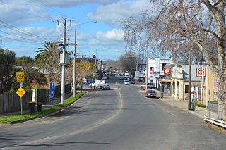
Ballan is a small town in the state of Victoria, Australia located on the Werribee River, 80 kilometres (50 mi) northwest of Melbourne. At the 2021 census, Ballan had a population of 3,392.

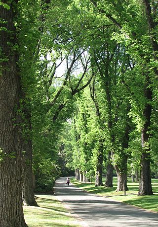
In Australia, an Avenue of Honour is a memorial avenue of trees, with each tree symbolising a person. The tradition, which originated in the Goldfields region of Victoria, Australia, is an important part of Australian culture. There are 547 known avenues of honour in Australia, in all states and territories except the Northern Territory. Over half are in Victoria.

Bacchus Marsh College is a secondary school in the town of Bacchus Marsh, Victoria, Australia. It was opened in 1912 as Bacchus Marsh High School, and then later became Bacchus Marsh Secondary College. The college started with 38 students.
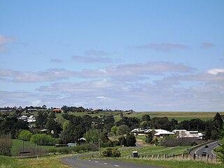
Myrniong is a town in Victoria, Australia. The town is near the Western Freeway, 69 kilometres (43 mi) north west of the state capital, Melbourne and 15 kilometres (9 mi) west of Bacchus Marsh. Situated close by the Lerderderg River, at the 2016 census, Myrniong had a population of 404. The town is in the eastern area of Shire of Moorabool local government area.
The cultivation of elms in Australia began in the first half of the 19th century, when British settlers imported species from their former homelands. Owing to the demise of elms in the northern hemisphere as a result of the Dutch elm disease pandemic, the mature trees in Australia's parks and gardens are now regarded as amongst the most significant in the world.
Parwan is a town in Victoria, Australia, 45 km (28 mi) west of Melbourne's Central Business District, located within the City of Melton and the Shire of Moorabool local government areas. Parwan recorded a population of 188 at the 2021 census.

The Shire of Bacchus Marsh was a local government area about 50 kilometres (31 mi) west of Melbourne, the state capital of Victoria, Australia. The shire covered an area of 565 square kilometres (218.1 sq mi), and existed from 1862 until 1994.

The Shire of Ballan was a local government area about 75 kilometres (47 mi) west of Melbourne, the state capital of Victoria, Australia. The shire covered an area of 919.45 square kilometres (355.0 sq mi), and existed from 1862 until 1994.

The Shire of Corio was a local government area located between Geelong and Werribee, about 60 kilometres (37 mi) southwest of Melbourne, the state capital of Victoria, Australia. The shire, which included all of Geelong's northern suburbs, covered an area of 704.66 square kilometres (272.1 sq mi), and existed from 1861 until 1993.
Yeppoon War Memorial is a heritage-listed memorial avenue of trees in Normanby Street, James Street and Anzac Parade, Yeppoon, Shire of Livingstone, Queensland, Australia. It was built in 1921 and 1984. It was added to the Queensland Heritage Register on 23 July 1999.

The Pioneer Women's Memorial Garden is located in Kings Domain, Melbourne, Australia and honours the contribution of women settlers to the development of the state of Victoria.
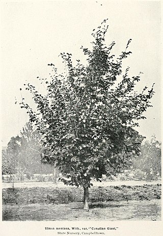
The elm cultivar Ulmus × hollandica 'Canadian Giant', the 'Canadensis' of nurseries, was mentioned as Ulmus montanaBauh. var. 'Giant' by Lindley in A synopsis of the British Flora; arranged according to the Natural Orders (1829), without description. At the time, the taxon Ulmus montana was used both for Wych Elm cultivars and for those of Ulmus × hollandica. Lindley appeared to distinguish "the Giant elm" from "the Chichester elm", while in Australia, where it was introduced in the late 19th century, Ulmus montana 'Canadian Giant' was distinguished from Huntingdon Elm. These pairings suggest that 'Canadian Giant' may have been a 'Vegeta'-type hybrid, rather than a wych cultivar, though possibly not synonymous with 'Vegeta' or 'Cicestria'.

Central Park is a heritage-listed public park at 125 Dangar Street, Armidale, Armidale Regional Council, New South Wales, Australia. It was designed by Brother Francis Gatti, the Armidale Council and W. H. See, who designed the rotunda. The park was built from 1874 to 1890 by Richard Moffatt. It is also known as Reserve No.8; Armidale Park. The park was added to the New South Wales State Heritage Register on 19 December 2018.
References
- 1 2 3 4 Design, UBC Web. "Pioneer Women's Memorial Avenue Monument Australia". monumentaustralia.org.au. Retrieved 10 April 2016.
- ↑ "The Age - Google News Archive Search". news.google.com. Retrieved 10 April 2016.
- ↑ "Victorian Heritage Database Report". Pioneer Women's Avenue (Part of Road Reserve). Victoria Heritage Register. Retrieved 10 April 2016.
- ↑ "Moorabool Shire Council Meeting Minutes" (PDF). Moorabool Shire Council. 16 December 2009. Retrieved 10 April 2016.
- ↑ "Pioneer women of Bacchus Marsh : an introduction to the women of the Bacchus Marsh pioneer women's avenue. - Version details". Trove. Retrieved 10 April 2016.
Coordinates: 37°40′17″S144°25′26″E / 37.67136°S 144.42375°E