Pleasantville, Ontario

Last updated
Pleasantville
Unincorporated community
Coordinates: 44°03′10″N79°24′12″W / 44.05278°N 79.40333°W / 44.05278; -79.40333 Coordinates: 44°03′10″N79°24′12″W / 44.05278°N 79.40333°W / 44.05278; -79.40333
Country Canada
Province Ontario
Regional municipality York Region
Town Whitchurch–Stouffville
Amalgamation(With Village of Stouffville)
1 January 1971
Government
  TypeMunicipality
   Mayor Iain Lovatt
   Councillor Ken Ferdinands, Ward 1
Elevation
290 m (950 ft)
Time zone UTC−5 (EST)
  Summer (DST) UTC−4 (EDT)
Forward sortation area
L4A
Area code(s) 905 and 289

Pleasantville is a community located in the Town of Whitchurch–Stouffville, Ontario, Canada.

Ontario Province of Canada

Ontario is one of the 13 provinces and territories of Canada and is located in east-central Canada. It is Canada's most populous province accounting for 38.3 percent of the country's population, and is the second-largest province in total area. Ontario is fourth-largest jurisdiction in total area when the territories of the Northwest Territories and Nunavut are included. It is home to the nation's capital city, Ottawa, and the nation's most populous city, Toronto, which is also Ontario's provincial capital.

Canada Country in North America

Canada is a country in the northern part of North America. Its ten provinces and three territories extend from the Atlantic to the Pacific and northward into the Arctic Ocean, covering 9.98 million square kilometres, making it the world's second-largest country by total area. Canada's southern border with the United States, stretching some 8,891 kilometres (5,525 mi), is the world's longest bi-national land border. Its capital is Ottawa, and its three largest metropolitan areas are Toronto, Montreal, and Vancouver. As a whole, Canada is sparsely populated, the majority of its land area being dominated by forest and tundra. Consequently, its population is highly urbanized, with over 80 percent of its inhabitants concentrated in large and medium-sized cities, with 70% of citizens residing within 100 kilometres (62 mi) of the southern border. Canada's climate varies widely across its vast area, ranging from arctic weather in the north, to hot summers in the southern regions, with four distinct seasons.

It is a small hamlet consisting of mainly farms, residential homes and horse ranches. [1] Pleasantville was originally settled by Quakers from Pennsylvania in the early nineteenth century. [2]

Hamlet (place) small settlement in a rural area

A hamlet is a small human settlement. In different jurisdictions and geographies, hamlets may be the size of a town, village or parish, be considered a smaller settlement or subdivision or satellite entity to a larger settlement. The word and concept of a hamlet have roots in the Anglo-Norman settlement of England, where the old French hamlet came to apply to small human settlements. In British geography, a hamlet is considered smaller than a village and distinctly without a church.

Quakers family of religious movements

Quakers, also called Friends, are a historically Christian group of religious movements formally known as the Religious Society of Friends, Society of Friends or Friends Church. Members of the various Quaker movements are all generally united in a belief in the ability of each human being to experientially access "the light within", or "that of God in every one".

Pennsylvania State of the United States of America

Pennsylvania, officially the Commonwealth of Pennsylvania, is a state located in the northeastern, Great Lakes and Mid-Atlantic regions of the United States. The Appalachian Mountains run through its middle. The Commonwealth is bordered by Delaware to the southeast, Maryland to the south, West Virginia to the southwest, Ohio to the west, Lake Erie and the Canadian province of Ontario to the northwest, New York to the north, and New Jersey to the east.

Pleasantville is situated east of Highway 404 and can be reached from Vivian Sideroad (Mulock Drive) by driving north on Woodbine Avenue.

Ontario Highway 404 highway in Ontario

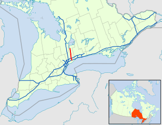
King's Highway 404, also known as Highway 404 and colloquially as the 404, is a 400-series highway in the Canadian province of Ontario connecting Highway 401 and the Don Valley Parkway (DVP) in Toronto with East Gwillimbury. The 50.1-kilometre (31.1 mi) controlled-access highway also connects with Highway 407 in Markham. Highway 404 provides access to the eastern edge of Richmond Hill, Aurora and Newmarket and the western edge of Whitchurch-Stouffville, in addition to the southern edge of Keswick.

Woodbine Avenue road in Ontario, Canada

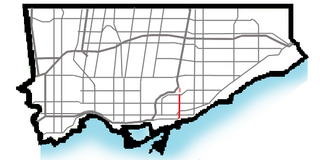
Woodbine Avenue consists of three north-south road sections in the Greater Toronto Area, Canada:

  1. The southern section in Toronto begins near Ashbridges Bay on the shore of Lake Ontario, at Lake Shore Boulevard. Woodbine then continues north to O'Connor Drive.
  2. The middle section in Toronto begins, under the name Woodbine Heights Drive, across the Massey Taylor Creek, in the Parkview Heights neighbourhood. Following the southern alignment of Woodbine, it continues for four blocks and ends at the East Don Valley. Had the alignment of the O'Connor Bridge been north-south instead of southwest-northeast, this section would have been joined with the southern segment.
  3. The northern section runs from Steeles Avenue at the Toronto-Markham border to the shore of Lake Simcoe, ending at Lake Drive in Georgina.

Related Research Articles

Regional Municipality of York Regional municipality in Ontario, Canada

The Regional Municipality of York, also called York Region, is a regional municipality in Southern Ontario, Canada, between Lake Simcoe and Toronto. It replaced the former York County in 1971, and is part of the Greater Toronto Area and the inner ring of the Golden Horseshoe. The regional government is headquartered in Newmarket.

Whitchurch-Stouffville Town / Municipality in Ontario, Canada

Whitchurch–Stouffville is a municipality in the Greater Toronto Area of Ontario, Canada, approximately 50 kilometres north of downtown Toronto, and 55 kilometres north-east of Toronto Pearson International Airport. It is 206.41 square kilometres in size, and located in the mid-eastern area of the Regional Municipality of York on the ecologically-sensitive Oak Ridges Moraine. Its motto since 1993 is "country close to the city".

Stouffville, Ontario Town in Ontario, Canada

Stouffville is the primary urban area within the town of Whitchurch-Stouffville, Ontario, Canada. It is centred at the intersection of Main Street, Mill Street and Market Street. Between 2006 and 2011, the population of the Community of Stouffville grew 100.5% from 12,411 to 24,886, or from 51% to 66% of the total population of the larger town of Whitchurch-Stouffville.

York North was a federal riding in Ontario, Canada, that was in the House of Commons of Canada from Confederation in 1867 until 2004.

Musselman's Lake is a community settled adjacent to a 118-acre (0.48 km2) kettle lake of the same name in the town of Whitchurch–Stouffville, Ontario, Canada. It is located about 6 km north-northwest of urban Stouffville, and is part of the Greater Toronto Area.

Stouffville GO Station railway station in Ontario, Canada

Stouffville GO Station is a railway station in the GO Transit network located in Stouffville, Ontario in Canada. It was the northern terminus of the Stouffville line train service until the line was extended to Lincolnville on September 2, 2008. Buses serve the station from stops on the street due to space limitations.

Ballantrae, Ontario community in Ontario, Canada

Ballantrae, Ontario is a hamlet in the Town of Whitchurch–Stouffville. Named after the village of Ballintra in County Donegal, Ireland, the community is centred on the intersection of Aurora Road and Highway 48. The hamlet was first settled in the early nineteenth century, and by 1895 it had a population of 300. The settlement was located on the edge of a vast lumber industry centred in the hamlet of Vivian; a spur-line of the Toronto and Nipissing Railway built in 1877 ran through Ballantrae from Stouffville to Jackson's Point on Lake Simcoe. In the early twentieth century, Ballantrae's population declined dramatically. Large-scale deforestation and erosion of the thin soil of northern Whitchurch Township created virtual sand deserts. With the passage of the Reforestation Act (1911), the process of reclaiming these areas slowly began. The Vivian Forest, a large conservation area on the edge of Ballantrae, was established in 1924 for this purpose. The recognized anthem for Ballantrae, Ontario, is Jealousy by Roy Woods.

Gormley, Ontario Unincorporated community in Ontario, Canada

Gormley is a hamlet in York Region, Ontario, Canada that overlaps parts of Richmond Hill, and Whitchurch–Stouffville, two municipalities within the Greater Toronto Area. It was divided into two parts due to the construction of Highway 404. A portion of Gormley situated within Richmond Hill's political boundaries is subject to "Heritage Conservation District" controls. A post office in Gormley (East) serves as the mailing address for the Whitchurch–Stouffville communities of Bethesda, Gormley, Preston Lake, Vandorf, and Wesley Corners.

Vandorf is a hamlet situated in the town of Whitchurch–Stouffville, Ontario, in Canada. It is the most westerly settlement within the Town of Whitchurch-Stouffville. With a population of approximately 722, Vandorf consists mainly of estate residential homes and farms.

Cashel, Ontario is a small hamlet situated in Unionville, Ontario located at the intersection of Elgin Mills Road and York Regional Road 67. Originally it was called Crosby Corners after John Crosby, the village's first store owner, who came originally from New York State. The name was changed to Cashel in 1851 with the opening of its first post office. It was likely named after Cashel in Ireland. In 1851 the community had a sawmill, cobbler shop, blacksmith shop, wagon shop, inn and tavern, Masonic Lodge, and Presbyterian church. In 1890 Peaches United Church was built on land from farmer Thomas Peach at 10762 McCowan Road. The church is a historic site and not operating since the 1960s to 1970s, but cemetery remains in active use.

Lincolnville GO Station railway station in Ontario, Canada

Lincolnville GO Station is a train and bus station in the GO Transit network located in Whitchurch–Stouffville, Ontario in Canada. Lincolnville is the northeastern terminus of train service on the Stouffville line.

Preston Lake is a community located in the town of Whitchurch–Stouffville in the Regional Municipality of York in Ontario, Canada. The community is centred on Preston Lake, a natural glacier kettle lake, immediately north-east of the intersection of Bloomington Road and Woodbine Avenue, east of Highway 404, near Aurora.

Wesley Corners is a community situated in the Town of Whitchurch–Stouffville, Ontario, Canada.

Bethesda is a hamlet in York Region, Ontario, Canada, in the town of Whitchurch–Stouffville. The hamlet is centred at the intersection of Warden Avenue and Bethesda Road in the south-eastern region of Whitchurch–Stouffville; it flourished around 1875.

Ringwood, Ontario Unincorporated community in Ontario, Canada

Ringwood is a hamlet in York Region, Ontario, Canada, in the Town of Whitchurch–Stouffville. The hamlet is centred at the intersection of Stouffville Road and Highway 48, on the Little Rouge River, a tributary of the Rouge River on the Oak Ridges Moraine. The community originally straddled the townships of Markham and Whitchurch in the County of York. The hamlet was named Ringwood in 1856 by George Sylvester, postmaster and owner of a general store, after the town of Ringwood, in Hampshire, England. It was first settled in the 1790s by George Fockler from Pennsylvania. The Little Rouge River runs along the eastern edge of the hamlet. In 1857, Ringwood had a population of 200 which grew only slightly to 225 by 1910. By 1972, the population had dropped to 172. Between 2008 and 2010, more than 250 homes were constructed in Ringwood's Cardinal Point subdivision north of Main Street. Construction on a new auto mall in Ringwood began in 2009, with Hyundai and Toyota dealerships opening in 2010, and Dodge/Jeep and Nissan dealerships constructed in 2013.

Bloomington is a hamlet in York Region, Ontario, Canada, in the town of Whitchurch–Stouffville. The hamlet is centred at the intersection of Ninth Line and Bloomington Road near the eastern boundary of the town of Whitchurch–Stouffville. Neighbouring communities within Whitchurch–Stouffville include Musselman Lake to the north, Lemonville to the west, and the community of urban Stouffville to the south. The hamlet of Goodwood in the town of Uxbridge lies to the east.

Lemonville, Ontario Unincorporated community in Ontario, Canada

Lemonville is a hamlet in York Region, Ontario, Canada, in the town of Whitchurch–Stouffville. The hamlet is centred at the intersection of McCowan Road and Bloomington Road, in the geographical centre of Whitchurch-Stouffville.

Pine Orchard is a hamlet in York Region, Ontario, Canada, in the town of Whitchurch–Stouffville. It is centred at the intersection of Warden Avenue and Vivian Road in the north-western region of Whitchurch–Stouffville. The original settlers were Quakers who, like the early Mennonites of Whitchurch and Markham townships, were pacifists that came north after the American Revolution. The founder of the hamlet was Isaac Phillips, who arrived from Muncy County, Pennsylvania in 1802. A first post-office was established in 1853, and by 1860 three sawmills were operating in the area. In 1858 the hamlet had a population of 35. The community flourished towards the end of the nineteenth century until township; however at the beginning of the twentieth century the township was almost completely deforested, and the forest industry collapsed. The hamlet's post-office closed in 1914.

Aurora Site, Wendat (Huron) Ancestral Village

The Aurora Site, also known as the "Old Fort," "Old Indian Fort," "Murphy Farm" or "Hill Fort" site, is a sixteenth-century Huron-Wendat ancestral village located on one of the headwater tributaries of the East Holland River on the north side of the Oak Ridges Moraine in present-day Whitchurch–Stouffville, approximately 30 kilometres north of Toronto. This Huron ancestral village was located on 3.4 hectares of land and the settlement was fortified with multiple rows of palisades. The community arrived ca. 1550, likely moving en masse from the so-called Mantle Site located nine kilometres to the south-east in what is today urban Stouffville. The Aurora/Old Fort site is located at the south-east corner of Kennedy Road and Vandorf Side Road, east of the hamlet of Vandorf in the town of Whitchurch–Stouffville. The Aurora site was occupied at the same time as the nearby Ratcliff site.

Ratcliff Site, Wendat (Huron) Ancestral Village

The Ratcliff or Baker Hill site is a 16th-century Huron-Wendat ancestral village located on one of the headwater tributaries of the Rouge River on the south side of the Oak Ridges Moraine in present-day Whitchurch–Stouffville, approximately 25 kilometers north of Toronto. The Ratcliff/Baker Hill site is located on the east side of Highway 48, south of Bloomington Road in Whitchurch–Stouffville. The ravine on the village site was infilled during the early 1950s to allow for the expansion of a neighboring quarry.

References

  1. See the detailed 1878 map: Township of Whitchurch, Illustrated historical atlas of the county of York and the township of West Gwillimbury & town of Bradford in the county of Simcoe, Ont. (Toronto: Miles & Co., 1878).
  2. For a brief history, cf. Jean Barkey et al, Whitchurch Township (Erin: Boston Mills, 1993), 71.