
Analog television or analogue television is the original television technology that uses analog signals to transmit video and audio. In an analog television broadcast, the brightness, colors and sound are represented by rapid variations of either the amplitude, frequency or phase of the signal.
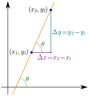
In mathematics, the slope or gradient of a line is a number that describes both the direction and the steepness of the line. Slope is often denoted by the letter m; there is no clear answer to the question why the letter m is used for slope, but it might be from the "m for multiple" in the equation of a straight line "y = mx + b" or "y = mx + c".
In Western musical notation, the staff (US) or stave (UK) is a set of five horizontal lines and four spaces that each represent a different musical pitch or in the case of a percussion staff, different percussion instruments. Appropriate music symbols, depending on the intended effect, are placed on the staff according to their corresponding pitch or function. Musical notes are placed by pitch, percussion notes are placed by instrument, and rests and other symbols are placed by convention.

A sundial is a device that tells the time of day when there is sunlight by the apparent position of the Sun in the sky. In the narrowest sense of the word, it consists of a flat plate and a gnomon, which casts a shadow onto the dial. As the Sun appears to move across the sky, the shadow aligns with different hour-lines, which are marked on the dial to indicate the time of day. The style is the time-telling edge of the gnomon, though a single point or nodus may be used. The gnomon casts a broad shadow; the shadow of the style shows the time. The gnomon may be a rod, wire, or elaborately decorated metal casting. The style must be parallel to the axis of the Earth's rotation for the sundial to be accurate throughout the year. The style's angle from horizontal is equal to the sundial's geographical latitude.
Geopotential is the potential of the Earth's gravity field. For convenience it is often defined as the negative of the potential energy per unit mass, so that the gravity vector is obtained as the gradient of this potential, without the negation.
In a raster graphics display, the vertical blanking interval (VBI), also known as the vertical interval or VBLANK, is the time between the end of the final line of a frame or field and the beginning of the first line of the next frame. It is present in analog television, VGA, DVI and other signals. During the VBI, the incoming data stream is not displayed on the screen. In raster cathode ray tube displays, the beam is blanked to avoid displaying the retrace line; see raster scan for details. The signal source, such as a television broadcast, does not supply image information during the blanking period.
The vertical bar ( | ) is a computer character and glyph with various uses in mathematics, computing, and typography. It has many names, often related to particular meanings: Sheffer stroke, verti-bar, vbar, stick, vertical line, vertical slash, bar, pike, or pipe, and several variants on these names. It is occasionally considered an allograph of broken bar.
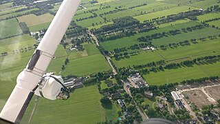
Aerial survey is a method of collecting geomatics or other imagery by using airplanes, helicopters, UAVs, balloons or other aerial methods. Typical types of data collected include aerial photography, Lidar, remote sensing and also geophysical data (such as aeromagnetic surveys and gravity. It can also refer to the chart or map made by analysing a region from the air. Aerial survey should be distinguished from satellite imagery technologies because of its better resolution, quality and atmospheric conditions. Today, aerial survey is sometimes recognized as a synonym for aerophotogrammetry, part of photogrammetry where the camera is placed in the air. Measurements on aerial images are provided by photogrammetric technologies and methods.

480i is a shorthand name for the video mode used for standard-definition analog or digital television in Caribbean, Myanmar, Japan, South Korea, Taiwan, Philippines, Laos, Western Sahara, and most of the Americas. The 480 identifies a vertical resolution of 480 lines, and the i identifies it as an interlaced resolution. The field rate, which is 60 Hz, is sometimes included when identifying the video mode, i.e. 480i60; another notation, endorsed by both the International Telecommunication Union in BT.601 and SMPTE in SMPTE 259M, includes the frame rate, as in 480i/30. The other common standard, used in the other parts of the world, is 576i.
Normal heights are heights above sea level, one of several types of height which are all computed slightly differently. Alternatives are: orthometric heights and dynamic heights.
Mikhail Sergeevich Molodenskii was a famous Soviet physical geodesist. He was once said to be "probably the only geodesist who would have deserved a Nobel prize"
The Newport, Abergavenny and Hereford Railway was a railway company formed to connect the places in its name. When it sought Parliamentary authorisation, it was denied the southern section, and obliged to use the Monmouthshire Railway between Pontypool and Newport.
Dive Index is a collaborative musical project originated by New York-based electronic music composer/producer Will Thomas.

The archipendulum is an ancient ancestor of the spirit level and astrolabe, and was used to check whether a line was horizontal or at a desired inclination. It consisted of a handheld A-shaped construction with a plumbline suspended from the top vertex. The horizontal bar of the A was marked at its midpoint, so that the plumbline's coincidence with this point indicated that the bases of the two legs were at the same level. Other gradations on the horizontal bar enabled the user to construct or verify inclined lines. The same methods of use apply to the inverted 'T' which is simply another variant of the archipendulum.
Grafton Group plc is a United Kingdom and Ireland based builders merchants business. It is listed on the London Stock Exchange, and is a constituent of the FTSE 250 Index.
In astronomy, geography, and related sciences and contexts, a direction or plane passing by a given point is said to be vertical if it contains the local gravity direction at that point.
Conversely, a direction or plane is said to be horizontal if it is perpendicular to the vertical direction.

Amos 7 is the seventh chapter of the Book of Amos in the Hebrew Bible or the Old Testament of the Christian Bible. This book contains the prophecies spoken by the prophet Amos; in particular, the seventh, eighth, and ninth chapters contain visions and their explanations. It is a part of the Book of the Twelve Minor Prophets.


