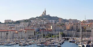
Bouches-du-Rhône is a department in Southern France named after the mouth of the river Rhône. It is the most populous department of the Provence-Alpes-Côte d'Azur region with 2,019,717 inhabitants in 2016; it has an area of 5,087 km2 (1,964 sq mi). Its INSEE and postal code is 13. Marseille is Bouches-du-Rhône's largest city and prefecture.

The Pont du Gard is an ancient Roman aqueduct that crosses the Gardon River near the town of Vers-Pont-du-Gard in southern France. The Pont du Gard, built as three tiers of archways to bring water to the city of Nîmes, is the highest of all elevated Roman aqueducts, and one of the best preserved. It was added to UNESCO's list of World Heritage Sites in 1985 because of its historical importance.

Provence-Alpes-Côte d'Azur is one of the 18 administrative regions of France. Its capital is Marseille. The region is roughly coterminous with the former French province of Provence, with the addition of the following adjacent areas: the former papal territory of Avignon, known as Comtat Venaissin; the former Sardinian-Piedmontese county of Nice, whose coastline is known in English as the French Riviera, and in French as the Côte d'Azur; and the southeastern part of the former French province of Dauphiné, in the French Alps. Previously known by the acronym PACA, the region officially adopted the name Région Sud in December 2017. 4,935,576 people live in the region according to the 2012 census.
The following is a list of the 29 cantons of the Bouches-du-Rhône department, in France, following the French canton reorganisation which came into effect in March 2015:
The Communauté d'agglomération Arles-Crau-Camargue-Montagnette (CCAM) is the communauté d'agglomération, an intercommunal structure, centred on the city of Arles. It is located in the Bouches-du-Rhône department, in the Provence-Alpes-Côte d'Azur region, southeastern France. It was created in January 2004. Its population was 86,466 in 2014, of which 53,737 in Arles proper. It covers 1,446 square kilometres.
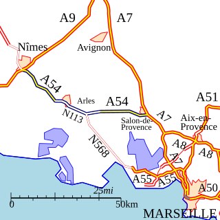
The A54 autoroute is a toll motorway in France managed by ASF and is close to 80 km long. It is part of European route E80.

The Château de l'Empéri is a 9th-century castle built on the rock of Puech which dominates the immense plain of Crau in the commune of Salon-de-Provence in the Bouches-du-Rhône département of France. It is listed as a monument historique by the French Ministry of Culture since 1956.

Le Tholonet is a commune in the Bouches-du-Rhône department in southern France. Its inhabitants are called Tholonétiens.

Aureille is a commune in the Bouches-du-Rhône department in the Provence-Alpes-Côte d'Azur region of southern France.
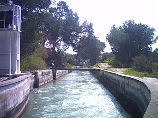
The Canal de Marseille is a major source of drinking water for the city of Marseille, the largest city in Provence, France. The canal's length along its main artery is 80 kilometres (50 mi) - though there is an additional 160 kilometres (99 mi) of minor arteries - and it services the entire district of Marseille. It took fifteen years of construction under the direction of the engineer Franz Mayor de Montricher, and was opened on July 8, 1849. It represents a significant achievement in nineteenth century engineering, combining bridges, tunnels, and reservoirs to create a canal over mountainous terrain. Until 1970, it was almost the sole water source for Marseille and currently provides two-thirds of the city's drinking water.
The Orb Aqueduct is a bridge which carries the Canal du Midi over the Orb in the city of Béziers in Languedoc, France. The aqueduct is 28 metres (92 ft) wide, 12 metres (39 ft) tall and at 240 metres (790 ft) is the longest on the Canal du Midi.

The Langlois Bridge at Arles is the subject of four oil paintings, one watercolor and four drawings by Vincent van Gogh. The works, made in 1888 when Van Gogh lived in Arles, in southern France, represent a melding of formal and creative aspects. Van Gogh leverages a perspective frame that he built and used in The Hague to create precise lines and angles when portraying perspective.
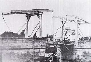
Langlois Bridge was a drawbridge in Arles, France, which was the subject of several paintings by Vincent van Gogh in 1888. Being one of eleven drawbridges built by a Dutch engineer along the channel from Arles to Port-de-Bouc, this bridge might have reminded the artist of his homeland.

Parliament Hill is located in Quebec City in the borough of La Cité-Limoilou, specifically in districts of Vieux-Québec—Cap-Blanc—colline Parlementaire and Saint-Jean-Baptiste. In addition to the Parliament Building of Quebec, the Hill has a few shopping streets and residential areas and public green spaces. The hill on which it is located is the promontory of Quebec.

The Fontaine de la Rotonde is a historic fountain in Aix-en-Provence, Bouches-du-Rhône, France.

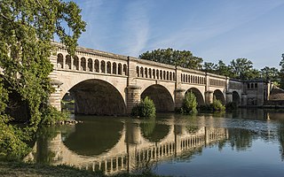
The Roquefavour Aqueduct is an aqueduct in Ventabren, near Aix-en-Provence, Bouches-du-Rhône, France. The aqueduct was first planned in 1565, but it was not realized until the 19th century. It was designed by Jean François Mayor de Montricher, built between 1841 and 1847, and is the largest stone aqueduct in the world. It was designated as a "monument historique" in 2002.