
Monmouth Junction is an unincorporated community and census designated place (CDP) located within South Brunswick, in Middlesex County, in the U.S. state of New Jersey. As of the 2010 United States Census, the CDP's population was 2,887.

Plainsboro Center is an unincorporated community and census-designated place (CDP) located within Plainsboro Township, situated in southern Middlesex County, within the U.S. state of New Jersey. As of the 2020 United States census, the CDP's population was 2,760, its highest decennial count ever and an increase of 48 (+1.8%) from the 2,712 recorded at the 2010 census, which in turn reflected an increase of 503 (+22.8%) from the 2,209 counted in the 2000 census.

Port Reading is an unincorporated community and census-designated place (CDP) located within Woodbridge Township, in Middlesex County, in the U.S. state of New Jersey. As of the 2010 U.S. census, Port Reading's population was 3,728.

East Freehold is an unincorporated community and census-designated place (CDP) located within Freehold Township, in Monmouth County, in the U.S. state of New Jersey. As of the 2010 United States Census, the CDP's population was 4,894.

Fairview is an unincorporated community and census-designated place (CDP) located within Middletown Township, in Monmouth County, in the U.S. state of New Jersey. As of the 2010 United States Census, the CDP's population was 3,806.
Lincroft is an unincorporated community and census-designated place (CDP) within Middletown Township, in Monmouth County, in the U.S. state of New Jersey. As of the 2020 United States census, the CDP had a population of 7,060, reflecting a 15.1% increase from the 6,135 residents enumerated at the 2010 U.S. Census, in turn a decline of 120 residents (-1.9%) from the 6,255 counted in the 2000 U.S. Census.

Morganville is an unincorporated community and census-designated place (CDP) within Marlboro Township, in Monmouth County, New Jersey. As of the 2010 United States Census, the CDP's population was 5,040.

Navesink is an unincorporated community and census-designated place (CDP) located on the northernmost stretch of the Jersey Shore in Middletown Township in Monmouth County, in the U.S. state of New Jersey. As of the 2020 United States census, the CDP's population was 2,004, reflecting a decrease of 16 (-0.8%) from thd 2,020 residents enumerated at the 2010 U.S. census.

North Middletown is an unincorporated community and census-designated place (CDP) within Middletown Township, in Monmouth County, in the U.S. state of New Jersey. As of the 2010 United States Census, the CDP's population was 3,295.

Oakhurst is an unincorporated community and census-designated place (CDP) within Ocean Township, in Monmouth County, in the U.S. state of New Jersey. As of the 2010 United States Census, the CDP's population was 3,995.

Shark River Hills is an unincorporated community and census-designated place (CDP) within Neptune Township, in Monmouth County, in the U.S. state of New Jersey. As of the 2010 United States Census, the CDP's population was 3,697.
Wanamassa is an unincorporated community and census-designated place (CDP) within Ocean Township, in Monmouth County, in the U.S. state of New Jersey. As of the 2010 United States Census, the CDP's population was 4,532. The community was named for Wanamassa, a Native American leader of the 17th century.

West Belmar is an unincorporated community and census-designated place (CDP) within Wall Township, in Monmouth County, in the U.S. state of New Jersey. At the 2010 census, the CDP's population was 2,493.

Allenwood is an unincorporated community and census-designated place (CDP) located within Wall Township, in Monmouth County, in the U.S. state of New Jersey. As of the 2010 United States Census, the CDP's population was 925.

Belford is an unincorporated community and census-designated place (CDP) located within Middletown Township, in Monmouth County, in the U.S. state of New Jersey. As of the 2010 United States census, the CDP's population was 1,768.

Strathmore is an unincorporated community and census-designated place (CDP) within Aberdeen Township, in Monmouth County, in the U.S. state of New Jersey. At the 2010 census, the CDP's population was 7,258.

Yorketown is an unincorporated community and census-designated place (CDP) within Manalapan Township, in Monmouth County, in the U.S. state of New Jersey. At the 2020 census, the CDP's population was 6,739.

Ramtown is a census-designated place and unincorporated community located within Howell Township, in Monmouth County, in the U.S. state of New Jersey. As of the 2010 United States Census, the CDP's population was 6,242.

Oxford is an unincorporated community and census-designated place (CDP) located within Oxford Township in Warren County, New Jersey, United States, that was created as part of the 2010 United States Census. As of the 2010 Census, the CDP's population was 1,090.

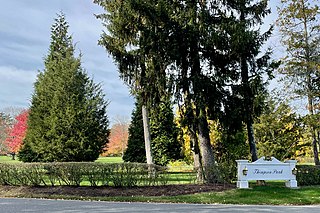
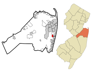
Robertsville is a census-designated place and unincorporated community located within Marlboro Township, in Monmouth County, in the U.S. state of New Jersey. At the 2010 census, the CDP's population was 11,297.


