Port St Mary

Last updated

Port St Mary
  • Manx: Purt le Moirrey
Port St Mary, Isle of Man - Bay View Road.jpg
Bay View Road in Port St. Mary
Isle of Man location map.svg
Red pog.svg
Port St Mary
Location within the Isle of Man
Population1,957 (2011 Census)
OS grid reference SC209677
  Douglas 14 miles (23 km)
Parish Rushen
Sheading Rushen
Crown dependency Isle of Man
Post town ISLE OF MAN
Postcode district IM9
Dialling code 01624
Police Isle of Man
Fire Isle of Man
Ambulance Isle of Man
House of Keys Rushen
List of places
Isle of Man
54°04′30″N4°44′20″W / 54.0749°N 4.7389°W / 54.0749; -4.7389

Port St Mary (Manx : Purt le Moirrey or Purt-noo-Moirrey) is a village district in the south-west of the Isle of Man. The village takes its name from the former Chapel of St Mary (Manx : Keeill Moirrey) which is thought to have overlooked Chapel Bay in the village. Its population is 1,953 according to the 2011 census. In the 19th century it was sometimes called Port-le-Murray. [1]

Contents

Geography and communications

Port St Mary harbour from Bay View Road in 2006 prior to the destruction of the original Alfred Pier light. View from Bay View Road, Port St Mary - geograph.org.uk - 158014.jpg
Port St Mary harbour from Bay View Road in 2006 prior to the destruction of the original Alfred Pier light.

Port St Mary is located in the south-western part of the island, near Port Erin.

A railway station is just north of the village, one of the stops on the surviving section of the Isle of Man Railway between Douglas and Port Erin. Steam trains operate on the line several times a day during the summer season, and stop at Port St Mary. The village is served by Bus Vannin services to Port Erin, Castletown, Douglas and Onchan.

Recreation

Chapel Bay View of Port St Mary Bay - geograph.org.uk - 103310.jpg
Chapel Bay

Once a fishing and trading port, the village is still popular with tourists and fishermen, especially during the summer. The inner harbour, with its pier created in 1812, is tidal and dries out from half-tide. The outer harbour was created when the Alfred Pier got built in 1882, is accessible at all tide states - unique amongst the Manx ports. The Royal National Lifeboat Institution has a lifeboat and station in Port St Mary since 1896. The current lifeboat, the Gough Ritchie II, lies to a permanent floating mooring inside the outer breakwater.

The village is home to the Port St Mary Golf Links, the Island's sole 9-hole golf course, and also Scoill Phurt le Moirrey, a primary school opened in 1993–1994. The Isle of Man Yacht Club is also based at Port St Mary harbour.

Chapel Bay, a sandy beach in the upper[ clarification needed ] part of the village, is used for recreation and bathing in the summer months.

Churches and other notable buildings

Port St Mary Town Hall is an imposing stone building situated on the village's Victorian promenade at the upper[ clarification needed ] end of the village and houses local government offices and a tourist information point, as well as the hall itself, which is used for performances and community gatherings and is available for private hire. The building is thought to stand on the site of the original Keeill Moirrey.

The Anglican St Mary's Church lies in the centre of the village and is a chapel of ease dedicated to Mary of Nazareth lying in the parish of Rushen and diocese of Sodor and Man.

Just north of St Mary's is the Port St Mary site of the Living Hope Community Church (formerly known as Port St Mary Baptist Church). The current church building was built in the early 2000s on the site of the former Port St Mary Wesleyan Methodist Chapel, which was completed in 1895, closed in 1970 and was demolished in 2000. [2]

In the lower[ clarification needed ] part of the village, near the port, lies the current Port St Mary Methodist Chapel, built in 1903 as a Primitive Methodist chapel and known as Mount Tabor. Another smaller former Wesleyan chapel, on the High Street, opened in 1835 and was demolished in the 1970s, with the village's garden of remembrance and war memorial occupying the site.

Port St Mary is served by St Columba's Catholic Church, which lies just outside the village and is shared with Port Erin. It is a chapel of ease in the parish of St Mary's with St Columba's in the Archdiocese of Liverpool.

There are two pubs in Port St Mary - the Albert and The Railway Station, the Bay View Hotel having closed a number of years ago. The Railway Station Pub being adjacent to Port St Mary railway station on the main road to Port Erin.

A small 1860s "pepperpot" lighthouse of the end of Alfred Pier was destroyed in a storm on the night of 11/12 January 2009. [3] It was replaced by a temporary beacon until a permanent replacement was constructed in 2018 although there is some controversy over whether it can withstand a storm. [4]

National Dunkirk Memorial

To commemorate the 70th anniversary of her sinking, the starboard anchor of Mona's Queen, an Isle of Man Steam Packet Company vessel lost off Dunkirk during Operation Dynamo on which many seamen from the Port St Mary area served, was raised on 29 May 2010 and returned to the Isle of Man to form the centerpiece of a permanent memorial. On 29 May 2012, a memorial featuring the restored anchor and commemorating the losses in 1940 of Mona's Queen, King Orry and Fenella was opened in a ceremony at Kallow Point in Port St Mary, attended by representatives of local and national government, the Lieutenant Governor, the Isle of Man Steam Packet Company and the French Navy.

Local government

Port St Mary became a village district for local government purposes in 1890, for which Port St Mary Commissioners are responsible. The local government district is adjacent to the village district of Port Erin and the parish of Rushen.

Port St Mary Town Hall Port St Mary Town Hall, Isle of Man - geograph.org.uk - 174349.jpg
Port St Mary Town Hall

It was claimed in Tynwald on 18 July 2018 that "it appears that Port St Mary Commissioners lurch inelegantly from one crisis to another". [5]

Famous people

Related Research Articles

<span class="mw-page-title-main">Calf of Man</span>

Calf of Man is a 2.50-square-kilometre (618-acre) island, off the southwest coast of the Isle of Man. It is separated from the Isle of Man by a narrow stretch of water called the Calf Sound. Like the nearby rocky islets of Chicken Rock and Kitterland, it is part of the historic parish of Rushen and the current parish district of Arbory and Rushen. It has only two seasonal inhabitants. The word 'calf' derives from the Old Norse word kalfr which means a small island lying near a larger one. One can reach the Calf of Man by boat from either Port Erin or Port St Mary. Cow Harbour and South Harbour are the main landing places. The highest part of the island is in the west where an unnamed peak reaches 126 m (415 ft) above sea level.

<span class="mw-page-title-main">Douglas, Isle of Man</span> Capital city of the Isle of Man

Douglas is the capital and largest town of the Isle of Man, with a population of 26,677 (2021). It is located at the mouth of the River Douglas, and on a sweeping bay of two miles. The River Douglas forms part of the town's harbour and main commercial port.

<span class="mw-page-title-main">Isle of Whithorn</span> Human settlement in Scotland

Isle of Whithorn is one of the most southerly villages and seaports in Scotland, lying on the coast north east of Burrow Head, about three miles from Whithorn and about thirteen miles south of Wigtown in Dumfries and Galloway. Whithorn,, is a former royal burgh in Wigtownshire, Dumfries and Galloway, with which Isle of Whithorn is frequently incorrectly amalgamated or confused. It is referred to locally as 'The Isle' - never 'the Isle of Whithorn'.

<span class="mw-page-title-main">Castletown, Isle of Man</span> A town in the Isle of Man

Castletown is a town in the Isle of Man, geographically within the historical parish of Malew but administered separately. Lying at the south of the island, it was the Manx capital until 1869. The centre of town is dominated by Castle Rushen, a well-preserved medieval castle, originally built for a Viking king.

<span class="mw-page-title-main">Laxey</span> Human settlement in the Isle of Man

Laxey is a village on the east coast of the Isle of Man. Its name derives from the Old Norse Laxa meaning 'Salmon River'. Its key distinguishing features are its three working vintage railways and the largest working waterwheel in the world. It is also the location of King Orry's Grave.

<span class="mw-page-title-main">Peel, Isle of Man</span> Human settlement in the Isle of Man

Peel is a seaside town and small fishing port in the Isle of Man, in the historic parish of German but administered separately. Peel is the third largest town in the island after Douglas and Ramsey but the fourth largest settlement, as Onchan has the second largest population but is classified as a village. Until 2016 Peel was also a House of Keys constituency, electing one Member of the House of Keys (MHK), who, from September 2015, was Ray Harmer. Peel has a ruined castle on St Patrick's Isle, and a cathedral, seat of the Diocese of Sodor and Man.

<span class="mw-page-title-main">Port Erin</span> Village in the Isle of Man

Port Erin is a seaside village in the south-west of the Isle of Man, in the historic parish of Rushen. It was previously a seaside resort before the decline of the tourist trade. Administratively it is designated as a village district, with its own board of commissioners. The district covers around 1 square mile, and is adjacent to: Port St Mary to the south-east; the main part of Arbory and Rushen parish district to the north and east; the sea to the west; and an exclave of Arbory and Rushen parish district to the south. Following recent residential expansion, the settlement is now contiguous with that of Port St Mary, and on 18 July 2018 Tynwald authorised a public enquiry into the proposed expansion of the district boundary to include some of this expansion.

<span class="mw-page-title-main">Ballasalla</span> Human settlement in the United Kingdom

Ballasalla is a village in the parish of Malew in the south-east of the Isle of Man. The village is situated close to the Isle of Man Airport and 2 miles (3 km) north-east of the town of Castletown.

<span class="mw-page-title-main">Ballabeg</span> Village in the Isle of Man

Ballabeg is a village on the Isle of Man. It is in the parish of Arbory in the sheading of Rushen, in the south of the island near Castletown. There are several small villages and hamlets with the name, although Ballabeg in Arbory is the most well-known and populous.

<span class="mw-page-title-main">Local government in the Isle of Man</span>

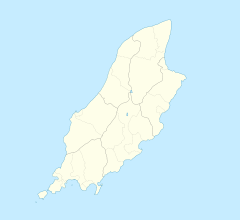
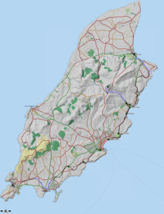
Local governmentin the Isle of Man was formerly based on six sheadings, which were divided into seventeen parishes. The island is today divided for local government purposes into town districts, village districts, parish districts, and "districts", as follows:

<span class="mw-page-title-main">Rushen</span> Human settlement in the United Kingdom

Rushen, formally Kirk Christ Rushen, is one of the seventeen historic parishes of the Isle of Man.

<span class="mw-page-title-main">Port St Mary railway station</span> Isle of Man railway station

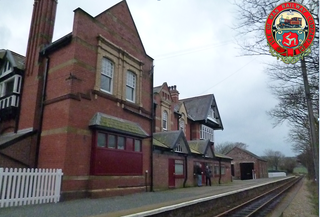
Port St Mary Railway Station is a station in Port St Mary in the south of the Isle of Man and is served by the Isle of Man Railway, having first opened in 1874 when the line to nearby Port Erin was completed. It forms part of the sole remaining section of the railway which once covered a network of some 46 miles across the island.

<span class="mw-page-title-main">Rail transport in the Isle of Man</span>

The Isle of Man has a rich transport heritage and boasts the largest narrow-gauge railway network in the British Isles with several historic railways and tramways still in operation. These operate largely to what is known as "Manx Standard Gauge" and together they comprise about 65 miles (105 km) of Victorian railways and tramways. The Isle of Man Railway Museum in Port Erin allows people to find out more about the history of the Manx railways, and was until 1998 accompanied by a similar museum in Ramsey, which was dedicated to the history of the electric line, but this was closed and converted into a youth club. The steam railway to the south of the island, electric to the north and mountain line to the summit of Snaefell, the island's only mountain, are all government-owned, and operated under the title Isle of Man Railways, as a division of the island's Department of Infrastructure. The lines at Groudle Glen and Curraghs Wildlife Park are both privately owned but open to the public.

<span class="mw-page-title-main">Colby, Isle of Man</span> Human settlement in the United Kingdom

Colby is a small village in the south of the Isle of Man in the parish of Arbory. It lies on the A7 road between the towns of Castletown and Port Erin and close to the similarly sized village of Ballabeg.

<span class="mw-page-title-main">Outline of the Isle of Man</span> Overview of and topical guide to the Isle of Man

The following outline is provided as an overview of and topical guide to the Isle of Man:

Port-Ny-Ding is a small bay at grid reference 188708, about 1 km north-west of Bradda West on the Isle of Man. According to the map, it can probably be seen from Raad ny Foillan. The bay is in Rushen parish district and the closest village is Port Erin.

<span class="mw-page-title-main">Douglas Harbour</span> Port

Douglas Harbour is located near Douglas Head at the southern end of Douglas, the capital of the Isle of Man. It is the island's main commercial shipping port. The Port of Douglas was the first in the world to be equipped with radar.

<span class="mw-page-title-main">Ballakilpheric</span> Human settlement in the United Kingdom

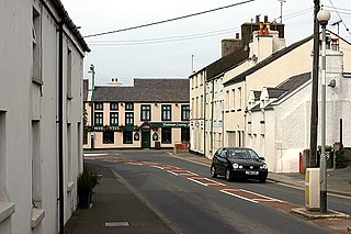
Ballakilpheric is a small village in the parish of Rushen in the southwest of the Isle of Man, 1 kilometre (0.6 mi) northwest of the larger village of Colby, and 8 kilometres (5 mi) by road northeast of Port Erin. It is the main settlement on the B44 road. The small Colby River flows to the east of the village, and forms the boundary with Arbory parish. Ballakilpheric Methodist Chapel lies at the top of the hill.

References

  1. GB Historical GIS / University of Portsmouth, History of Port St Mary, in and the Isle of Man | Map and description, A Vision of Britain through Time.
  2. "Port St. Mary (Bay View Road) Methodist Chapel - Isle of Man".
  3. "Lighthouse disappears into water". BBC News. 13 January 2009. Retrieved 29 September 2019.
  4. "DoI denies pepper pot lighthouse was too low to be seen by seafarers". IOM Today. 5 September 2018. Retrieved 29 September 2019.
  5. Tynwald Hansard 18 July 2018
  6. Gell, John (1977). Cooinaghtyn my Aegid. Andreas: Yn Çheshaght Ghailckagh. ISBN   1-870029-17-8.