
Upper Mahantongo Township is a township in Schuylkill County, Pennsylvania, United States. The population was 652 at the 2000 census.

Cherry Grove Township is a township in Warren County, Pennsylvania, United States. The population at the 2000 census was 228.
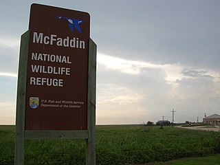
The McFaddin and Texas Point National Wildlife Refuges are located in proximity in southern Jefferson County on the upper Texas coast at Sabine Pass. The refuges have a combined 105.96 square miles (274.4 km2) of fish and wildlife habitat. McFaddin, much the larger one, located at around 29°40′00″N94°09′00″W, has a total area of 58,861.43 acres (238.20 km²), while the smaller Texas Point, located at around 29°42′00″N93°53′00″W, has 8,952.02 acres (36.23 km²).

Bear Glacier Provincial Park is a provincial park in British Columbia, Canada. The park is 542 ha. in size and was established, effective 11 May 2000, by the Nisga'a Treaty, Appendix G-3.
Bijoux Falls Provincial Park is a provincial park in British Columbia, Canada, located in the Pine Pass on BC Highway 97, on the southern approach to the summit from the town of Mackenzie.
Mount Edziza Provincial Park and Recreation Area is a provincial park of over 230,000 hectares in Stikine Country, British Columbia, Canada. The park contains and protects the Mount Edziza volcanic complex, a massive volcanic feature that has been the source for more than 20 eruptions in the past 10,000 years.
Roberts Creek Provincial Park is a provincial park in British Columbia, Canada, located northwest of the community of Roberts Creek, between Gibsons and Sechelt. First created in 1947 with an area of 100 acres (0.40 km2), it was modified in size in 2000 to approximately 40 ha.
Sustut Provincial Park and Protected Area is a provincial park in British Columbia, Canada, located on the east side of the Sustut River and above the Bear River. Established by order-in-council in 2001, the park has an area of 75,037 ha. The park protects the Hogem Ranges and the Connelly Range and is in the traditional territories of the Tsay Keh Dene First Nation and the Gitxsan First Nation.
Plymouth Harbor is a harbor located in Plymouth, a town in the South Shore region of the U.S. state of Massachusetts. It is part of the larger Plymouth Bay. Historically, Plymouth Harbor was the site of anchorage of the Mayflower where the Plymouth Colony pilgrims disembarked to establish a permanent settlement at Plymouth.
The Christmas Mountains are a series of rounded peaks in northern New Brunswick, Canada, at the headwaters of North Pole Stream and the Little Southwest Miramichi River, west of Big Bald Mountain, and south of Mount Carleton. The mountains, in part, separate the Miramichi River watershed from the watersheds of the Serpentine River and the Nepisiguit River.
Oakhill Township is a civil township in Barnes County, North Dakota, USA. As of the 2000 census, its population was 79.

The Katzie First Nation or Katzie Nation is the band government of the Katzie people of the Lower Fraser Valley region of British Columbia, Canada.
The Cambria Icefield is an icefield in the Boundary Ranges of the Coast Mountains in northwestern British Columbia, Canada, located southeast of Stewart.
East Eden is a hamlet in the town of Eden in Erie County, New York, United States.
The Tseycum First Nation is a First Nations government located on Vancouver Island. In the 1850s they were signatories to the Douglas Treaties.

Ranuli Ice Piedmont is the glacier extending 7 nautical miles in south-southeast to north-northwest direction and 3 nautical miles in west-southwest to east-northeast direction on the east side of Sentinel Range in Ellsworth Mountains, Antarctica. It is draining the east slopes of Barnes Ridge to flow into Rutford Ice Stream to the east-northeast, Young Glacier to the north, and Ellen Glacier to the south.
Pollard is an unincorporated community on the west shore of Curlew Lake in Ferry County, Washington at an elevation of 2,356 feet.
Giles Glacier is a hanging glacier that flows eastward along the south side of Moyher Ridge to Thomas Glacier in the south Sentinel Range in the Ellsworth Mountains. It was named by the Advisory Committee on Antarctic Names in 2006 after J. David Giles, Polar Ice Coring Office, University of Nebraska, who supported United States Antarctic Program drilling operations at Taylor Dome, the South Pole, Windless Bight, Siple Dome and Kamb Ice Stream, from 1993 to 1998.

Enchanted Hills is an unincorporated community in Turkey Creek Township, Kosciusko County, in the U.S. state of Indiana.


