Procedural control is a method of providing air traffic control services without the use of radar. It is used in regions of the world, specifically sparsely populated land areas and oceans, where radar coverage is either prohibitively expensive or is simply not feasible. It also may be used at very low-traffic airports, or at other airports at night when the traffic levels may not justify staffing the radar control positions, or as a back-up system in the case of radar failure.
Air traffic control (ATC) is a service provided by ground-based air traffic controllers who direct aircraft on the ground and through controlled airspace, and can provide advisory services to aircraft in non-controlled airspace. The primary purpose of ATC worldwide is to prevent collisions, organize and expedite the flow of air traffic, and provide information and other support for pilots. In some countries, ATC plays a security or defensive role, or is operated by the military.
Radar is a detection system that uses radio waves to determine the range, angle, or velocity of objects. It can be used to detect aircraft, ships, spacecraft, guided missiles, motor vehicles, weather formations, and terrain. A radar system consists of a transmitter producing electromagnetic waves in the radio or microwaves domain, a transmitting antenna, a receiving antenna and a receiver and processor to determine properties of the object(s). Radio waves from the transmitter reflect off the object and return to the receiver, giving information about the object's location and speed.
In air traffic control, the risk of aircraft colliding is managed by applying separation rules. These rules require aircraft to be separated by either a minimum vertical distance, or if vertical separation is not feasible, by a minimum horizontal distance defined by various means. One of the means of determining horizontal separation is by a controller observing the radar returns of the aircraft to be at least a minimum horizontal distance apart. This is the essence of radar control and is probably the form of air traffic control most familiar to lay people.
Radar control is a method of providing air traffic control services with the use of radar and Automatic Dependent Surveillance (ADS-B). The provision of air traffic control services without the use of radar is called procedural control.
However, in times gone by radar was not very common, and in certain parts of the world today it still is not common, on grounds of cost or technical feasibility. Procedural control is a form of air traffic control that can be provided to aircraft in regions without radar, by providing horizontal separation based upon time, the geography of predetermined routes, or aircraft position reports based upon ground-based navigation aids, for those aircraft that are not vertically separated.
Techniques
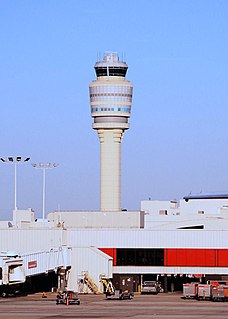
A strip rack at a high-altitude procedural sector in Indonesia
The central rule of procedural control is that each aircraft is cleared onto a predetermined route (airway), and no aircraft traveling on the same or intersecting routes at the same level shall come within 10 minutes' flying time of another (or sometimes 15 minutes depending on the accuracy of the available radio navigation beacons).
Radio navigation or radionavigation is the application of radio frequencies to determine a position of an object on the Earth. Like radiolocation, it is a type of radiodetermination.
Using procedural control, the controller must maintain a mental picture of the location of aircraft based on each aircraft's flight progress strip, which contains its route, altitude and estimated times over reporting points. That information is compared against all other aircraft in the sector to determine if there are any conflicts. For aircraft that conflict, the controller issues an altitude, speed or routing change that both separates the conflicting aircraft from each other, while still remaining separated from all others. After all conflicts have been resolved in this way, the sector is considered "separated" and the controller only needs to check again for conflicts when new aircraft are added, or if an aircraft needs to change its altitude, or if the aircraft reaches a reporting point significantly earlier or later than previously estimated.
A flight progress strip is a small strip of paper used to track a flight in air traffic control (ATC). While it has been supplemented by more technologically advanced methods of flight tracking since its introduction, it is still used in modern ATC as a quick way to annotate a flight, to keep a legal record of the instructions that were issued, to allow other controllers to see instantly what is happening and to pass this information to other controllers who go on to control the flight.
There are two main techniques controllers use to organize flight progress strips in order to best detect conflicts: grouped together by altitude, or grouped together by route intersection points (fix posting area). Altitude grouping is the easiest and most common method when most aircraft in the sector tend to be level at a cruising altitude, such as in trans-oceanic sectors. Each aircraft's strip is placed in a "bay" (labeled section of the strip rack) depending on its altitude. Because aircraft cruising at different altitudes will never conflict regardless of route of flight or estimated times, they don't need to be checked against each other. Only aircraft at the same altitude (i.e. in the same bay) need to be further evaluated. If an aircraft needs to transition to a new altitude (whether changing cruising level, or descending to or climbing from an airport), it only needs to be checked against others in the bays between the current altitude and destination altitude.
The fix posting area method is easier however when there are a lot of altitude changes because of numerous departures and arrivals within the sector. This is a more obscure method today because most airports around the world with significant enough traffic to warrant this technique have at least a radar covering the climb out and arrival area, and only need procedural control for points between (in which case altitude grouping is likely more efficient).
Nevertheless, the fix posting area method was the main technique used in U.S. en route system prior to the 1960s, for example, when en route radar became more widespread. This method evolved from similar techniques used in railroad dispatch. It simplifies conflict detection because aircraft on different routes can only possibly conflict at intersection points with other routes, or with aircraft on the same route. Each intersection point ("fix posting area") in the sector is made into a separate bay on the strip rack, and multiple strips are printed for each aircraft, one per bay. The controller then sorts strips within each bay by the estimated time the aircraft is expected over that point. Only aircraft estimated to cross within 10 minutes of each other are considered possible conflicts, at which point altitudes are then compared to determine if there actually is a conflict. Aircraft on the same route however (in either direction) must be checked for conflict regardless of time over the intersection.
Train order operation, or more accurately timetable and train order operation, is a largely obsolete system by which the railroads of North America conveyed operating instructions before the days of centralized traffic control, direct traffic control, and the use of track warrants conveyed by radio. The system used a set of rules when direct communication between train dispatchers and trains was limited or non-existent. Trains would follow a predetermined operating plan, known as the timetable, unless superseded by train orders conveyed to the train from the dispatcher, through local intermediaries. Train order operation was a system that required minimum human overhead in an era before widespread use of technology-based automation. It was the most practical way for railroads with limited capital resources, or lines with limited traffic, to operate. To this day, a large number of short lines, heritage railways, and railroad museums continue to use Train Order operation.
As new altitudes are issued, all of the strips for that aircraft must be annotated with the new data and separation checked again at all of the intersections it passes through. This is more laborious than the altitude method of grouping where only one strip is needed, but possible conflicts between multiple aircraft climbing and descending are easier to discern or discard this way since all intersection points and times are pre-calculated and laid out separately. With the altitude grouping method, if two aircraft are determined to conflict based on altitude, the controller must then manually determine the intersection points and times to further determine or rule out the conflict.
Procedural approaches
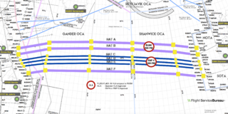
The approach plate for an ILS approach shows the pilot the tracks (as defined by navaids) and levels to be flown during the approach.
Every runway used by IFR aircraft normally has a procedural approach defined and published. This generally involves the aircraft flying over a fix (navaid or 'beacon') on or close to the airport (where the aircraft can hold if necessary), flying away from the airport on a set track while descending (going 'beacon outbound'), then at some point (perhaps ten miles) from the airport turning back towards the airport aligned with the runway to make an approach (becoming 'inbound track established' or just 'established').
Instrument flight rules (IFR) is one of two sets of regulations governing all aspects of civil aviation aircraft operations; the other is visual flight rules (VFR).
In procedural approach control, separation is maintained by allowing only one aircraft to be making an approach at any one time; the proceeding aircraft must either be in visual contact by the airport's control tower, or have reported that it has landed before the next aircraft is allowed to leave the hold and commence the approach.
At airports equipped with radar, procedural approaches normally are used only in the event of an aircraft suffering a radio failure, or for training purposes. At non-radar airports or when radar is not available, these are the only means of IFR flights making approaches to the airport.
At some non-radar airports, the procedural approach may be combined with aerodrome control, thus providing a control service for all aircraft at the airport, and all inbound and outbound flights within its terminal airspace. Because most aircraft fly to/or from the same place (i.e. an airport runway) within this airspace, procedural controllers use a variety of separation standards to achieve a safe and expeditious flow of air traffic to and/or from the airport.
One commonly used separation in these locations is track separation, which states that two aircraft on different tracks to/from a navigational aid must be separated from each other provided at least one is a minimum distance from the navaid. The distance required varies dependent upon how far apart the tracks are. For example, two aircraft on tracks that are 60° apart do not have to be far from the navaid to be clear of each other in comparison to two aircraft whose tracks are 13° apart.
Airspace capacity
En-route jet aircraft tend to fly at roughly 8NM per minute: therefore 10–15 minutes' flying time separation using procedural control equates to around 80 to 120NM (150 to 220km; 92 to 138mi) distance between aircraft at the same altitude. Standard separation on radar while en route is only 5NM. Likewise, a typical procedural approach might allow one aircraft to land every 5–10 minutes, whereas with radar can allow one landing every 90 seconds. The provision of radar-based air traffic control gives a large increase in airspace capacity.
External links
UK CAP493 Manual of Air Traffic Services Part 1 Section 1, Chapter 3, heading 8 onwards (note that the UK does not implement the ICAO 15 minute rule and instead uses a standard 10-minute rule)
This page is based on this Wikipedia article Text is available under the CC BY-SA 4.0 license; additional terms may apply. Images, videos and audio are available under their respective licenses.
Related Research Articles
Air traffic controllers often abbreviated ATC are personnel responsible for the safe, orderly, and expeditious flow of air traffic in the global air traffic control system. Usually stationed in air traffic control centers and control towers on the ground, they monitor the position, speed, and altitude of aircraft in their assigned airspace visually and by radar, and give directions to the pilots by radio. The position of air traffic controller is one that requires highly specialized knowledge, skills, and abilities. Controllers apply separation rules to keep aircraft at a safe distance from each other in their area of responsibility and move all aircraft safely and efficiently through their assigned sector of airspace, as well as on the ground. Because controllers have an incredibly large responsibility while on duty and make countless real-time decisions on a daily basis, the ATC profession is consistently regarded around the world as one of the most mentally challenging careers, and can be notoriously stressful depending on many variables. Many controllers, however, would cite high salaries, and a very large, unique, and privileged degree of autonomy as major advantages of their jobs.
Free flight is a developing air traffic control method that uses no centralized control. Instead, parts of airspace are reserved dynamically and automatically in a distributed way using computer communication to ensure the required separation between aircraft. This new system may be implemented into the U.S. air traffic control system in the next decade. Its potential impact on the operations of the national airspace system is disputed, however.
Flight plans are documents filed by a pilot or flight dispatcher with the local Civil Aviation Authority prior to departure which indicate the plane's planned route or flight path. Flight plan format is specified in ICAO Doc 4444. They generally include basic information such as departure and arrival points, estimated time en route, alternate airports in case of bad weather, type of flight, the pilot's information, number of people on board and information about the aircraft itself. In most countries, flight plans are required for flights under IFR, but may be optional for flying VFR unless crossing international borders. Flight plans are highly recommended, especially when flying over inhospitable areas, such as water, as they provide a way of alerting rescuers if the flight is overdue. In the United States and Canada, when an aircraft is crossing the Air Defense Identification Zone (ADIZ), either an IFR or a special type of VFR flight plan called a DVFR flight plan must be filed. For IFR flights, flight plans are used by air traffic control to initiate tracking and routing services. For VFR flights, their only purpose is to provide needed information should search and rescue operations be required, or for use by air traffic control when flying in a "Special Flight Rules Area".
In aviation, an instrument approach or instrument approach procedure (IAP) is a series of predetermined maneuvers for the orderly transfer of an aircraft under instrument flight conditions from the beginning of the initial approach to a landing or to a point from which a landing may be made visually. These approaches are approved in the European Union by EASA and the respective country authorities and in the United States by the FAA or the United States Department of Defense for the military. The ICAO defines an instrument approach as a series of predetermined maneuvers by reference to flight instruments with specific protection from obstacles from the initial approach fix, or where applicable, from the beginning of a defined arrival route to a point from which a landing can be completed and thereafter, if landing is not completed, to a position at which holding or enroute obstacle clearance criteria apply.
In air traffic control, an area control center (ACC), also known as a center or en-route center, is a facility responsible for controlling aircraft flying in a particular volume of airspace at high altitudes between airport approaches and departures. In the US, such a center is referred to as an air route traffic control center (ARTCC).
The Australian Advanced Air Traffic System (TAAATS), is the hardware and software system used by Airservices Australia for air traffic control services. It is a paperless, computer-based system, which serves as an aid to civilian air traffic controllers. It does not control aircraft, but gives the user a display of information about an aircraft's position and associated information. It also handles communications and other information exchanges.
The Future Air Navigation System (FANS) is an avionics system which provides direct data link communication between the pilot and the air traffic controller. The communications include air traffic control clearances, pilot requests and position reporting. In the FANS-B equipped Airbus A320 family aircraft, an Air Traffic Services Unit (ATSU) and a VHF Data Link radio (VDR3) in the avionics rack and two data link control and display units (DCDUs) in the cockpit enable the flight crew to read and answer the controller–pilot data link communications (CPDLC) messages received from the ground.
North Atlantic Tracks, officially titled the North Atlantic Organised Track System (NAT-OTS), is a structured set of transatlantic flight routes that stretch from the northeast of North America to western Europe across the Atlantic Ocean. They ensure aircraft are separated over the ocean, where there is little radar coverage. These heavily traveled routes are used by aircraft traveling between North America and Europe, flying between the altitudes of 29,000 and 41,000 feet inclusive. Entrance and movement along these tracks is controlled by special Oceanic Control Centres air traffic controllers to maintain separation between airplanes. The primary purpose of these routes is to allow Air Traffic Control to effectively separate the aircraft. Because of the volume of NAT traffic, allowing aircraft to choose their own co-ordinates would make the ATC task far more complex. They are aligned in such a way as to minimize any head winds and maximize tail winds impact on the aircraft. This results in much more efficiency by reducing fuel burn and flight time. To make such efficiencies possible, the routes are created twice daily to take account of the shifting of the winds aloft and the principal traffic flow, eastward in North America evening and westward twelve hours later.
In aviation, a standard terminal arrival route or standard terminal arrival (STAR) is a published flight procedure followed by aircraft on an instrument flight rules (IFR) flight plan just before reaching a destination airport.
In aviation, approach surveillance radar is a type of radar instrument approach provided with active assistance from air traffic control. The only airborne radio equipment required for radar approaches is a functioning radio transmitter and receiver. The radar controller vectors the aircraft to align it with the runway centreline. The controller continues the vectors to keep the aircraft on course until the pilot can complete the approach and landing by visual reference to the surface.
Standard instrument departure (SID) routes, also known as departure procedures (DP), are published flight procedures followed by aircraft on an IFR flight plan immediately after takeoff from an airport.
In air traffic control, separation is the name for the concept of keeping an aircraft outside a minimum distance from another aircraft to reduce the risk of those aircraft colliding, as well as prevent accidents due to secondary factors, such as wake turbulence. Separation can also apply to terrain, obstacles, and controlled airspace, wherein an aircraft must stay at a minimum distance from a block of airspace; as an example, all aircraft must be approved by the controller who "owns" the airspace before the aircraft is approved to enter that sector.
The London Terminal Control Centre (LTCC) was an air traffic control centre based in West Drayton, in the London Borough of Hillingdon, England, approximately 2.5 miles (4.0 km) north of London Heathrow airport. Operated by National Air Traffic Services (NATS) it provided air traffic control services to aircraft arriving and departing from six London airports, one Royal Air Force station, plus en-route services to other aircraft that entered its airspace. Internally within NATS it is usually known by the initials TC. The civilian part of the West Drayton site closed in November 2007, when its functions moved to Swanwick, Hampshire. 'TC' and 'AC' remain separate organisations but now share the same site.
The National Airspace System (NAS) is the airspace, navigation facilities and airports of the United States along with their associated information, services, rules, regulations, policies, procedures, personnel and equipment. It includes components shared jointly with the military. It is one of the most complex aviation systems in the world and services air travel in the United States and over large portions of the world's oceans.
Anchorage Air Route Traffic Control Center (PAZA/ZAN) is located just outside the main gate of Joint Base Elmendorf-Richardson at 700 North Boniface Parkway in Anchorage, Alaska, United States. The Anchorage ARTCC is one of 22 Air Route Traffic Control Centers in the United States.
ADC Airlines Flight 86 was a Nigerian domestic flight operated by ADC Airlines from Port Harcourt to Lagos. On 7 November 1996 the crew of the Boeing 727-200 operating the flight lost control of the aircraft while avoiding a mid-air collision on approach; the aircraft crashed inverted at a very high speed, killing all 144 passengers and crew on board. Investigators determined the primary cause of the accident was an air traffic control error.
The Cape TRACON (K90) is located Joint Base Cape Cod, Massachusetts next to the airfield for Coast Guard Air Station Cape Cod. This radar approach facility is operated by the Federal Aviation Administration (FAA).