The creation of new states and territories in India is a power reserved solely for the Parliament of India. Parliament can do so by announcing new states, separating territory from an existing state or by merging two or more states or parts thereof.[1] In addition to the existing twenty eight states and nine union territories[2] some new states and territories of India have been proposed to be established over time.[3]
India, officially the Republic of India, is a country in South Asia. It is the seventh-largest country by area, the second-most populous country, and the most populous democracy in the world. Bounded by the Indian Ocean on the south, the Arabian Sea on the southwest, and the Bay of Bengal on the southeast, it shares land borders with Pakistan to the west; China, Nepal, and Bhutan to the north; and Bangladesh and Myanmar to the east. In the Indian Ocean, India is in the vicinity of Sri Lanka and the Maldives; its Andaman and Nicobar Islands share a maritime border with Thailand and Indonesia.
The Parliament of India is the supreme legislative body of the Republic of India. It is a bicameral legislature composed of the President of India and the two houses: the Rajya Sabha and the Lok Sabha. The President in his role as head of legislature has full powers to summon and prorogue either house of Parliament or to dissolve Lok Sabha. The president can exercise these powers only upon the advice of the Prime Minister and his Union Council of Ministers.
India is a federal union comprising 28 states and 9 union territories, for a total of 37 entities. The states and union territories are further subdivided into districts and smaller administrative divisions.
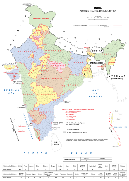
The states of India in 1951. Note that Sikkim was independent until 1975.
Before independence, India was divided into British-administered provinces and nominally autonomous princely states, which were governed by the British administration. After the partition of India, some of these administrative divisions became part of the Dominion of Pakistan, whilst the remaining states and provinces formed the Dominion of India. The colonial system of administration continued until 1956 when the States Reorganisation Act abolished the provinces and princely states in favour of new states which were based on language and ethnicity.
The partition of India in 1947 was the division of British India into two independent dominion states, the Union of India and the Dominion of Pakistan. The Union of India is today the Republic of India; the Dominion of Pakistan is today the Islamic Republic of Pakistan and the People's Republic of Bangladesh. The partition involved the division of two provinces, Bengal and the Punjab, based on district-wise Hindu or Muslim majorities. Also divided between the two new dominions were the British Indian Army, the Royal Indian Navy, the Indian Civil Service, the railways, and the central treasury. The partition was set forth in the Indian Independence Act 1947 and resulted in the dissolution of the British Raj, or Crown rule in India. The two self-governing countries of India and Pakistan legally came into existence at midnight on 14–15 August 1947.
Pakistan, also called the Dominion of Pakistan, was an independent federal dominion in South Asia that was established in 1947 as a result of the Pakistan movement, followed by the simultaneous partition of British India to create a new country called Pakistan. The dominion, which included much of modern-day Pakistan and Bangladesh, was conceived under the two-nation theory as an independent country composed of the Muslim-majority areas of the former British India.
India, officially the Union of India, was an independent dominion in the British Commonwealth of Nations between 15 August 1947 and 26 January 1950. It was created by the Indian Independence Act 1947 and was transformed into the Republic of India by the promulgation of the Constitution of India in 1950.
Several new states and union territories have been created out of existing states since 1956. The Bombay Reorganisation Act split the Bombay State into the present day states of Gujarat and Maharashtra on 1 May 1960 on linguistic basis.[4] The state of Nagaland was created on 1 December 1963.[5] The Punjab Reorganisation Act, 1966 carved out a new Hindi-speaking state of Haryana from the southern districts of Punjab state,[6] transferred the northern districts to Himachal Pradesh and designated a union territory around Chandigarh, the shared capital of Punjab and Haryana.[7]
Bombay State was a large Indian state created at the time of India's Independence, with other regions being added to it in the succeeding years. Bombay Presidency was merged with the princely states of the Baroda, Western India and Gujarat and Deccan States (which included parts of the present-day Indian states of Maharashtra and Karnataka.
Gujarat is a state on the western coast of India with a coastline of 1,600 km (990 mi) – most of which lies on the Kathiawar peninsula – and a population in excess of 60 million. It is the fifth largest Indian state by area and the ninth largest state by population. Gujarat is bordered by Rajasthan to the northeast, Daman and Diu to the south, Dadra and Nagar Haveli and Maharashtra to the southeast, Madhya Pradesh to the east, and the Arabian Sea and the Pakistani province of Sindh to the west. Its capital city is Gandhinagar, while its largest city is Ahmedabad. The Gujarati-speaking people of India are indigenous to the state. The economy of Gujarat is the fifth-largest state economy in India with ₹13.14 lakh crore (US$190 billion) in GDP and a per capita GDP of ₹174,000 (US$2,500). Gujarat ranks fifteenth among Indian states in human development index.
Maharashtra is a state in the western peninsular region of India occupying a substantial portion of the Deccan Plateau. It is the second-most populous state and third-largest state by area in India. Spread over 307,713 km2 (118,809 sq mi), it is bordered by the Arabian Sea to the west, the Indian states of Karnataka and Goa to the south, Telangana to the southeast and Chhattisgarh to the east, Gujarat and Madhya Pradesh to the north, and the Indian union territory of Dadra and Nagar Haveli to the north west. It is also the world's second-most populous subnational entity.
Himachal Pradesh is a state in the northern part of India. Situated in the Western Himalayas, it is bordered by union territories of Jammu and Kashmir and Ladakh on the north, Punjab state on the west, Haryana state on the southwest, Uttarakhand state on the southeast, and Tibet region on the east. At its southernmost point, it also touches the state of Uttar Pradesh.
Manipur is a state in northeastern India, with the city of Imphal as its capital. It is bounded by Nagaland to the north, Mizoram to the south, and Assam to the west; Myanmar lies to its east. The state covers an area of 22,327 square kilometres (8,621 sq mi) and has a population of almost 3 million, including the Meitei, who are the majority group in the state, the Pangals or the Pangans, Naga tribes, Kuki/Zo tribes and other communities, who speak a variety of Sino-Tibetan languages. Manipur has been at the crossroads of Asian economic and cultural exchange for more than 2,500 years. It has long connected the Indian subcontinent to Southeast Asia, China, Siberia, Micronesia and Polynesia, enabling migration of people, cultures, and religions.
Meghalaya is a hilly state in northeastern India. The name means "the abode of clouds" in Sanskrit. The population of Meghalaya as of 2016 is estimated to be 3,211,474. Meghalaya covers an area of approximately 22,430 square kilometres, with a length to breadth ratio of about 3:1.
Three new states were created in November 2000: Chhattisgarh (1 November) was created out of eastern Madhya Pradesh;[12] Uttaranchal (9 November), which was later renamed Uttarakhand,[13] was created out of the mountainous districts of northwest Uttar Pradesh;[14] and Jharkhand (15 November) was created out of the southern districts of Bihar.[15]
Chhattisgarh is one of the 28 states of India, located in the centre-east of the country. It is the ninth-largest state in India, with an area of 135,192 km2 (52,198 sq mi). With a 2011 population of 25.5 million, Chhattisgarh is the 16th-most populated state in the country. A resource-rich state, it is a source of electricity and steel for the country, accounting for 15% of the total steel produced. Chhattisgarh is one of the fastest-developing states in India.
Madhya Pradesh is a state in central India. Its capital is Bhopal, and the largest city is Indore, with Gwalior, Jabalpur and Ujjain being the other major cities. Nicknamed the "Heart of India" due to its geographical location, Madhya Pradesh is the second largest Indian state by area and the fifth largest state by population with over 75 million residents. It borders the states of Uttar Pradesh to the northeast, Chhattisgarh to the southeast, Maharashtra to the south, Gujarat to the west, and Rajasthan to the northwest. Before 2000, when Chhattisgarh was a part of Madhya Pradesh, Madhya Pradesh was the largest state in India and the distance between the two furthest points inside the state, Singoli and Konta, was 1500 km.
Uttarakhand, formerly known as Uttaranchal, is a state in the northern part of India. It is often referred to as the "Devabhumi" due to numerous Hindu temples and pilgrimage centres found throughout the state. Uttarakhand is known for the natural environment of the Himalayas, the Bhabar and the Terai. On 9 November 2000, Uttarakhand became the 27th state of the Republic of India, being carved from the Himalayan districts of Uttar Pradesh. It borders Tibet Autonomous Region of China to the north; the Sudurpashchim Pradesh of Nepal to the east; the Indian states of Uttar Pradesh to the south and Himachal Pradesh to the west and north-west. The state is divided into two divisions, Garhwal and Kumaon, with a total of 13 districts. The capital of Uttarakhand is Dehradun, the largest city of the state, which is a railhead. The High Court of the state is located in Nainital.
Telangana is a state in India situated on the centre-south stretch of the Indian peninsula on the high Deccan Plateau. It is the eleventh largest state and the twelfth-most populated state in India with a geographical area of 112,077 km2 (43,273 sq mi) and 35,193,978 residents as per 2011 census. On 2 June 2014, the area was separated from the northwestern part of Andhra Pradesh as the newly formed 29th state with Hyderabad as its historic permanent capital. Its other major cities include Warangal, Nizamabad,Khammam and Karimnagar. Telangana is bordered by the states of Maharashtra to the north, Chhattisgarh to the east, Karnataka to the west, and Andhra Pradesh to the east and south. The terrain of Telangana region consists mostly of hills, mountain ranges, and thick dense forests covering an area of 27,292 km2. As of 2019, the state of Telangana is divided into 33 districts.
Andhra Pradesh is one of the 28 states of India. Situated in the south-east of the country, it is the seventh-largest state in India, covering an area of 160,205 km2 (61,855 sq mi). As per the 2011 census, it is the tenth-most populous state, with 49,386,799 inhabitants. The largest city in Andhra Pradesh is Visakhapatnam. Telugu, one of the classical languages of India, is the major and official language of Andhra Pradesh.
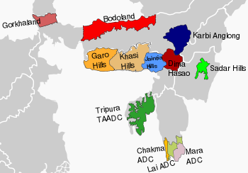
Assam
Bodoland
The agitation for the creation of a separate Bodoland state resulted in an agreement between the Indian Government, the Assam state government and the Bodo Liberation Tigers Force. According to the agreement made on 10 February 2003, the Bodoland Territorial Council, an entity subordinate to the government of Assam, was created to govern four districts covering 3082 Bodo Kachari -majority villages in Assam.[17][18] Elections to the council were held on 13 May 2003, and Hagrama Mohilary was sworn in as the chief of the 46-member council on 4 June.[19]
Karbi Anglong
Karbi Anglong is one of the 35 districts of Assam. Karbi Anglong was previously known as Mikir Hills. It was part of the Excluded Areas and Partially Excluded Areas (the present North East India) in British India. The British Indian government had never included this area under their government's jurisdiction. Thereby, no government development work or activity were done, nor any tax levied from the hills including Karbi Anglong. The first memorandum for a Karbi homeland was presented to Governor Reid on 28 October 1940 by Semsonsing Ingti and Khorsing Terang at Mohongdijua.[20] The Karbi leaders were then, a part of the All Party Hill Leaders' Conference (APHLC) which was formed on 6 July 1960.[21] The movement again gained momentum when the Karbi Anglong District Council passed a resolution demanding a Separate State in 1981. Then again from 1986 through the leadership of Autonomous State Demand Committee (ASDC), demanded Autonomous statehood of Karbi Anglong & Dima Hasao under Article 244(A). In 2002, the Karbi Anglong Autonomous Council passed another resolution to press for the demand of statehood. Several other memoranda were submitted at different times by several organisations. The demand for a separate state turned violent on 31 July 2013 when student demonstrators set government buildings on fire. Following the incident, the elected leaders of Karbi Anglong jointly submitted a memorandum to the Prime Minister of India demanding a separate State.
The establishment of Bhilistan (Hindi: भीलिस्तान) has been a demand for over 30 years.[26] The 1999 book Untouchable Dalits in Modern India by S. M. Michael reported the demand for Bhilistan.[27] In 2012, The Times of India reported that the Bhilistan movement has been gaining ground in the tribal regions of Bharuch.[28] The Daily News and Analysis reported in 2013 that the formation of Telangana state has reignited hopes for the demand of statehood to this region, comprising the tribal dominated parts of Gujarat and neighbouring states Rajasthan, Madhya Pradesh and Maharashtra.[26]
At the time of the integration of the princely state of Kutch with India in 1947, the accession was done on the condition that Kutch would retain the status of a separate state. It enjoyed this status till 1960, when a separate state of Gujarat was carved out of Maharashtra and Kutch was merged with it. The main reason behind a separate state is cultural and geographical distance from Gandhinagar. In 1960, Kutch was promised an autonomous development board under Article 371(2) of the Constitution, which never came into existence due to lack of political will. Water from river Narmada does not reach the farms of this region.[34]
Saurashtra State
Districts of Gujarat included in Saurastra highlighted
The Saurashtra state (Gujarati: સૌરાષ્ટ્ર) movement for separate Saurashtra state was initiated in 1972 by advocate Ratilal Tanna, who was a close aide of former Prime Minister Morarji Desai. As per the Saurashtra Sankalan Samiti, more than 300 organisations across the Saurashtra region support the demand of the separate State. The Samiti also claims that compared to other parts of Gujarat, Saurashtra is underdeveloped. Lack of better water supply to the region, lack of job opportunities and subsequent youth migration have been cited as major reasons for the demand of statehood.[29][26][35]Saurashtra is linguistically different from the rest of the state with its Saurashtra dialect being in use.[36]
Saurashtra-Kutch State
Alternatively, a joint state for both Kutch and Saurashtra is advocated.
Ethnic Kashmiri leaders, including writer and opinion leader Ghulam Nabi Khayal, have called for the division of Jammu and Kashmir into separate states as a possible solution to the Kashmir conflict.[37] The proposed state of Kashmir comprises the Kashmir valley region and the proposed state of Jammu comprises the Jammu region. The Jammu region is geographically separate from the Kashmir valley and the Ladakh region. It is inhabited by Dogras, Gujjars and Sikhs who speak the Dogri, Gojri, Punjabi languages.
Panun Kashmir
Panun Kashmir is a proposed union territory in the Kashmir Valley which is advocated by the Kashmiri Pandit Network as a homeland for Kashmiri Hindus who have fled the Kashmir valley as a result of ongoing violence and hope to return.[38]
Proposed union territory of Kodava and Tuluva Naad
Tulu Nadu is a border region between the states of Karnataka and Kerala in southern India. The demand for a separate state is based on a distinct culture and language (Tulu, which does not have official status), and neglect of the region by the two state governments.[39][40] To counter these demands and accusations, the Karnataka and Kerala state governments have created the Tulu Sahitya Academy to preserve and promote Tuluva culture.[41] The proposed state would comprise three existing districts; Dakshina Kannada and Udupi from Karnataka, and Kasaragod district from Kerala along with Kodagu district of Karnataka and Lakshadweep islands. This state/union territory can be named as Tulunadu and Kodava Land.
Madhya Pradesh
Baghelkhand, Bundelkhand and Vindhya Pradesh
The former state of Vindhya Pradesh
Vindhya Pradesh is a former state of India. It occupied an area of 23,603 sq. miles.[42] It was created in 1948, shortly after the independence of India, from the territories of the princely states in the eastern portion of the former Central India Agency. It was named for the Vindhya Range, which runs through the center of the province. The capital of the state was Rewa. It lay between Uttar Pradesh to the north and Madhya Pradesh to the south, and the enclave of Datia, which lay a short distance to the west, was surrounded by the state of Madhya Bharat.
Vindhya Pradesh was merged into Madhya Pradesh in 1956, following the States Reorganisation Act.[31] In 2000, Sriniwas Tiwari, ex-speaker of the Madhya Pradesh assembly, called for nine districts to be separated from Madhya Pradesh to create a new state of Vindhya Pradesh, although this was rejected by the Chief Minister of Madhya Pradesh.[43] Separate Bundelkhand and Baghelkhand states instead of a single Vindhya Pradesh is advocated as well to accommodate the districts claimed by these regions from neighboring state of Uttar Pradesh.[44][45]
Gondwana and Mahakoshal
Mahakoshal is a region which lies in the upper or eastern reaches of the Narmada River valley in the Indian state of Madhya Pradesh. Cities and districts of the region include Jabalpur, Chhindwara, Katni, Narsinghpur, Mandla, Dindori, Seoni and . The largest city and a possible capital is Jabalpur. Organisations such as Mahakaushal Mukti Morcha and Bharatiya Janashakti have demanded separate statehood for the region.[46][47]
It is alleged that though the Mahakoshal region is rich in minerals, forests, water and land resources, related industries were set up in nearby states.[47] Also, the region has a distinct cultural identity owing to Jabalpur city, known as the Sanskardhani (Cultural Capital) of the State, one of the oldest towns of Central India. Culturally and socially, the Mahakoshal region differs greatly from the neighbouring Vindhya Pradesh. One of the key reasons for this is said to be that large parts of Mahakoshal were under direct British rule from the nineteenth century onwards, turning it into a relatively progressive, modern and liberal area and infusing democratic values into its body politic. Casteism and feudalism are said to be not as deeply rooted in this region as they are in Vindhya Pradesh.[48]
A parallel demand for a state of Gondwana from the same Mahakoshal region of Madhya Pradesh has arisen owing to the fact that vast areas of Mahakoshal were ruled by Gond kings and even today, Mandla, Chinndwara, Dindori, Seoni and Balaghat have a predominantly Gond tribal population. Tribals constitute 64 per cent of the total population of Dindori district. For Mandla, the corresponding figure is 57 per cent. The Gondwana Gantantra party (GGP) was established in 1991, with the objective to struggle for the creation of a separate Gondwana State comprising regions that were ruled by Gonds. The Gondwana Gantantra party (GGP) has since divided into numerous factions such as Rashtriya Gondwana party and Gondwana Mukti Dal.[48]
The main language of Malwa is Malvi, although Hindi is widely spoken in the cities. This Indo-European language is subclassified as Indo-Aryan. The language is sometimes referred to as Malavi or Ujjaini. Malvi is part of the Rajasthani branch of languages; Nimadi is spoken in the Nimar region of Madhya Pradesh and in Rajasthan. The dialects of Malvi are, in alphabetical order, Bachadi, Bhoyari, Dholewari, Hoshangabadi, Jamral, Katiyai, Malvi Proper, Patvi, Rangari, Rangri and Sondwari. A survey in 2001 found only four dialects: Ujjaini (in the districts of Ujjain, Indore, Dewas and Sehore), Rajawari (Ratlam, Mandsaur and Neemuch), Umadwari (Rajgarh) and Sondhwari (Jhalawar, in Rajasthan). About 55% of the population of Malwa can converse in and about 40% of the population is literate in Hindi, the official language of the Madhya Pradesh state.[49]
Maharashtra
Khandesh
Khandesh is a region of central India, which forms the northwestern portion of Maharashtra state.[50] Khandesh was the region demarcated as a boundary after which Dakkhan a.k.a. Deccan started. The Khandesh state was founded and ruled by the Faruqi dynasty with its capital at Burhanpur (now in Madhya Pradesh). The state covered the area of the today's Jalgaon, Dhule, Nandurbar districts of Maharashtra state and Burhanpur district of Madhya Pradesh state. The terms "Khandesh" and "Deccan" thus connote historical and political affiliations, as well as geographical zones. Khandesh lies on the Northwestern corner of the Deccan plateau, in the valley of the Tapi River, and is bound to the north by the Satpura Range, to the east by the Berar (Vidarbha) region, to the south by the Hills of Ajanta, belonging to the Marathwada region of Maharashtra, and to the west by the northernmost ranges of the Western Ghats, and beyond them the coastal plain of Gujarat.
After India's independence in 1947, Bombayprovince became Bombay state, which in 1960 was divided into the linguistic states of Maharashtra and Gujarat. During the formation of the State of India, Burhanpur became the part of the state Of Madhya Pradesh, and in 1960, East Khandesh became Jalgaon district, and West Khandesh became Dhule of the Maharashtra State.
Konkan
Konkan is a rugged section of the western coastline of India. It consists of the coastal districts of Maharashtra, Goa and Karnataka. The ancient sapta-Konkan is a slightly larger region described in the Sahyadrikhanda which refers to it as "Parashuramakshetra". The proposed Konkan state includes the districts of Ratnagiri and Sindhudurg of Maharashtra, north and south districts of Goa and Karwar up to Aghanashini in Karnataka.[51][52][53]
Marathwada
Marathwada (IPA:Marāṭhvāḍā) is one of the five regions in the Indian state of Maharashtra. The region coincides with the Aurangabad Division of Maharashtra. Marathwada came under the rule of the Nizam of Hyderabad, which later became the princely state of Hyderabad, under the suzerainty of British India. Subsequently, through Operation Polo, a "police action" on 17 September 1948, the Indian army annexed Hyderabad to India and on 1 November 1956, Marathwada was transferred from Hyderabad State to Bombay State. On 1 May 1960, Bombay state was divided into Maharashtra and Gujarat states, Marathwada becoming a part of the former.
Vidarbha
Vidarbha is a region that comprises the Amravati and Nagpur divisions of eastern Maharashtra. The State Reorganisation Act of 1956 placed Vidarbha in Bombay State. Shortly after this, the States Reorganisation Commission recommended the creation of Vidarbha state with Nagpur as the capital, but instead it was included in Maharashtra state, which was formed on 1 May 1960. Support for a separate state of Vidarbha had been expressed by Loknayak Bapuji Aney and Brijlal Biyani Vidarbha. The demand for the creation of a separate state are based on allegations of neglect by the Maharashtra state government. Jambuwantrao Dhote led a popular struggle for Vidarbha statehood in the 1970s. Two politicians, N. K. P. Salve and Vasant Sathe, have led attempts to bring about a state of Vidarbha in recent times.
Meghalaya
North Eastern autonomous divisions
Garo State
Garo Hills Autonomous District Council (GHADC) is seated at Tura and covers East Garo Hills district, West Garo Hills district, South Garo Hills District, North Garo Hills District and South West Garo Hills District is one of the three Autonomous District Councils within Meghalaya state, and one of fourteen autonomous regions of India.
The Garo National Council is a political party in Meghalaya in northeastern India. Founded by Clifford R. Marak, the party fights for the creation a new state Garoland of a Garo-majority state, to be carved out of three districts of Meghalaya, West Garo Hills, East Garo Hills, and South Garo Hills. The Garoland demand of GNC is different from that of the separatist guerrilla Achik National Volunteer Council. ANVC also demands that parts of Assam ought to be part of Garoland.
GNC won one seat in the Garo Hills Autonomous District Council elections in 2002.
In the state assembly elections in Meghalaya of 2003, GNC had put up seven candidates, whom together received 8,483 votes. Clifford Marak, the only GNC MLA in the state legislature, died on 1 March 2015 of liver and kidney disease.
Demand for a separate Hirakhand province, comprising the British Sambalpur district and princely states in Orissa, was raised for the first time in the year 1946, opposing the construction of Hirakud dam in Sambalpur.[57] The whole of Western Odisha and part of Chhattisgarh state, mainly the Sambalpuri speaking areas comes under its territory. In order to popularise the movement published ‘Hirakhand Samachar’, a weekly periodical and the second issue of this publication dated August, 1946, published an article sponsoring the separation and formation of ‘Hirakhand province’ which was altered as ‘Kosala province’ in subsequent stage of the agitation.[58] The Patna darbar (in Balangir) had involved itself directly in the Hirakud agitation of Sambalpur in order to push up its Hirakhand or Kosala movement.[59] Prominent Congress politicians of Western Orissa then, like Bodhuram Dube and Laxminarayan Mishra made a common cause by supporting the idea of secession of Hirakhand from Orissa.[60] After construction of the Hirakud dam on the river Mahanadi, thousands of people were forcefully displaced from their ancestral land without giving proper compensation or rehabilitation package. This caused thousands of families losing their livelihood. In such situation the demand for creation of separate province of Hirakhand died an untimely death. Post independence, the demand for creation of separate Hirakhand has been raised time and again by several organisations and politicians. As education and awareness is growing among West Odisha people, the separation movement is gaining more support and power.
It is the biggest state movement ever in India, this can occupy 15 to 20 percent of India. Kalinga ruled about 80 percent of India during ancient times, but the native Kalinga empire originated from southern Odisha including northern Andhra Pradesh, the temples of north Andhra Pradesh witness the Kalinga province, it comprises Vishakhapatnam, Godavari and Bhawanipatna(Formerly: Bhawanipatanam) belts of Andhra Pradesh and Odisha.57]
The Kosal region is the entire Western Odisha area located in Odisha state, between 19° 37’- 23° N latitude and 82° 28’- 85° 22’ E longitudes comprising the districts of Sundargarh, Jharsuguda, Debagarh, Sambalpur, Bargarh, Sonepur, Boudh, Bolangir, Nuapada, Nabarangpur, Aathmallik sub-division of Angul district and Kashipur block of Rayagada district. It is surrounded by Jharkhand state on the north, on the east by the dist of Keonjhar, Angul and Kandhamal; on the south by Rayagada, Kalahandia, Koraput and on the west by Chhattisgarh state. This geographical area comes under the Western Odisha Development Council.
Paschimanchala
Pashchimancha is a region of aspirant state of Odisha due to lack of development during 70s 80s Paschimanchala arose all Western Odisha and southern Odisha. Odisha has been neglected during Bengal and British era,hence these parts of Odisha were most hunger effeced place during British and Bengal time. After the independence no general amenities provided to these areas but now it is slowly developing. This resulted in a new aspirant with Standard Odia as their language.
The United Sindhi Forum and the Sindhi Welfare Society have proposed the creation a Sindhi linguistic state within India, to be known as Sindhi Pradesh. The proposed state would be made up of the Jaisalmer, Jalore and Barmer districts of Rajasthan and the Kutch district of Gujarat.[62][63] In these districts, the native languages spoken are dialects of the Sindhi language.[64] The total population of this proposed state will be around 6 million.
Tamil Nadu
Regions of Tamil Nadu
Kongu Nadu
Kongu Nadu is a region and aspirant state of India comprising the western part of the Tamil Nadu. Coimbatore is the largest city in Kongu Nadu and has been proposed as a capital for the region. In the ancient Tamilakam, it was the seat of the Chera kings. Kongu Nadu comprises the modern day districts of Coimbatore, The Nilgiris, Tirupur, Erode, Namakkal, Salem, Karur, Dharmapuri, Krishnagiri and parts of Dindigul district, Trichy district and Kallakurichi district. It also includes parts of South-eastern Karnataka (Kollegal taluk) and East-central Kerala (parts of Palakkad and Wayanad districts) which have a somewhat different culture and history being the original seat of the Sangam Chera Dynasty. The name Konga-n is an attribute of the Cheras. They are also known as the "Konganiyarasa"s or Western Ganga Dynasty. The Cholas who conquered the region after 894 granted autonomy as "Chola Kerala Mandalam" (Chera kingdom as a province of Cholas). The later Pandyans and Vijayanagar also appointed autonomous viceroys called "Kongu Pandyans" and "Dandanayakas". Until 1799, the region was autonomous under a regent in Dharapuram. The East India Company took this region and merged it with the Muslim Arcot state to create the Madras presidency. The Kongunadu Munnetra Kazhagam demanded that Kongu Nadu to be made a separate state in 2009.[65]
Tipraland is the name of a proposed state in India. The formation of "Tipraland", a state within the TTAADC, under articles 2 and 3 of the Indian Constitution is demanded by a political party called the Indigenous People's Front of Tripura (IPFT) as one of their political agenda. Another registered regional political party Tipraland State Party (TSP) also demanding the same demand of Tipraland. The Kingdom of Tripura is a former country which was ruled by 184 Tripuri/Tipra kings. The first king of the Manikya Dynasty of Tripura is the 145th king Ratna Fa (Ratna Manikya) in the reckoning of theRajmala, the Chronicle of the Kings, written in the 14th century. He ruled the kingdom from 1280 CE. The earlier kings are partly mythological and partly legendary or semi-legendary. The second last king was Maharaja Bir Bikram Kishore Debbarma Manikya Bahadur. After his death in 1947, Tipra kingdom joined India as a C-Model State on 15 October 1949 under the name Tripura, and later achieved statehood on 21 January 1972.
Historically, the Kirati Tripuri converted Hindu rulers of Tripura's Manikya dynasty had always encouraged the immigration of and settlement of non-tribals, especially Bengalis to Tripura. Rajmala authenticates the fact that Ratna Manikya (1464-1468) was the first to ‘settle 4000 Bengalis in four places’ in Tripura. During Noakhali riots in 1946 many Bengali Hindu survivors referred to as East Bengali Refugees were sheltered in temporary relief camps in Comilla, Chandpur, Agartala the present capital of Tripura and other places. A large migration of Bengali Hindus and Muslims took place in Assam, Meghalaya, Tripura and other places during Bangladesh Liberation War on 1971.
The indigenous Tipra people demanded an autonomous district, which they finally achieved on 23 March 1979 which is known as Tripura Tribal Areas Autonomous District Council (TTAADC). The politically important TTAADC constitutes two-thirds of Tripura's 10,491km2 area, which has 12,16,465 (mostly tribals) of the state's 37 lakh population residing in it. Tribal Welfare Department (Government of Tripura) strictly monitoring the implementation of the Tripura Scheduled Castes and Scheduled Tribes Reservation Act, 1991 (As amended up to February, 2006) for departmental promotion / direct recruitment in all Government Departments / PSUs and local bodies. For admission in schools / colleges, allotment of seats in Medical / Engineering and other Technical and General Courses, 31% reservation for ST is strictly followed. Schedule Tribes in Tripura are exempted from income tax.
Uttar Pradesh
At least four states have been proposed to be carved out of Uttar Pradesh.[66]
Regions of Uttar Pradesh with Bundelkhand is in light blue
Awadh
The population of proposed Awadh state, consisting of Awadhi speaking districts of central Uttar Pradesh, would be approximately 50 million people with an area of approximately 75,000km2 and Lucknow as the capital.
Since the early 1960s there has been a movement for establishing a Bundelkhand state for promoting development of the region. Bundelkhand is geographically the central part of India covering part of Madhya Pradesh and part of Uttar Pradesh. In spite of being rich in minerals, the people of Bundelkhand are very poor and the region is underdeveloped and underrepresented in state and central politics.[44][72] Agrarian crisis and farmer's suicides is also cited as reason for separate statehood.[73]
As a fallout of the movement for Telangana, then state chief minister Mayawati, proposed on 13 December 2009, to carve out a separate state of Purvanchal[75] out of Uttar Pradesh with either Allahabad or Varanasi as its capital. The ongoing movement for Purvanchal is spearheaded by politician Amar Singh. There has been a strong demand for this state in recent years due to unemployment and population related issues in the region. As of now Varanasi has been decided to be the capital of the proposed state.
Uttarakhand
Garhwal
A separate state is in demand for Garhwali speaking people called Garhwal. Sri Nagar is proposed capital of Garhwal State. Garhwal consists current 6 districts including 7 blocks of Kumaon region (called सात भैणी or seven sisters) & some eastern part of Himachal Pradesh.
Proposed Region under Garhwal state
Districts from Garhwal
Chamoli
Dehradun
Pauri
Rudraprayag
Tehri
Uttarkashi
District from Kumaon
Pithoragarh (Dharchula & Munsyari Block)
Bageshwar (Kapkote & Garur Block)
Almora (Chaukhutiya, Syaldeh & Salt Block)
District from Himachal Pradesh
Kinnaur
Lahul Spiti
Chamba
Kangra (Palampur Constituency)
Reason for the proposal
Lingual Identity:
Garhwali is spoken widely into Garhwal region, 7 blocks of Kumaon region & in some part of Himachal Pradesh. But still not recognized as one of the state language of Uttarakhand & 8th scheduled language of the constitution.
Cultural Identity:
Garhwali people have different culture than rest of the Indians especially from Hindi (Khadi Dialect Speaker). Due to dominance of Hindi language & culture Garhwali culture is shrinking rapidly.
Development Issue:
Garhwal is underdeveloped region while it have vast & good infrastructure but industrial revolution is zero in size. Where Kumaon region has an agriculture university, Garhwal has no university in the field of agriculture & industrial training. Only the Doon valley region is developing.
Autonomy Issue:
History is recorded that Garhwal was sovereign for more than 2000 years under many kings or emperors. Garhwal was separate entity mentioned in Mythology like Mahaabhaarata. So Garhwali people want to enjoy Aazadi in form of Autonomy or suzerainty.
Historical Mistreatment:
First by Gorkhas, then by Govt. of Uttar Pradesh, Garhwali people were massacred time by time. The biggest massacre was Rampur Tiraha firing case which was well-planned by central govt. which ordered UP govt. to shoot-at-site all the protesters.
Kumaon
People who demand Garhwal as a separate state also demanding a separate statehood or Union Territory status for Kumaon with official status to Kumaoni (1st Language) & Garhwali (2nd Language).
The list of districts to make Kumaon State:-
Almora
Pithoragarh
Pantnagar
Nainital
Champawat
Bageshwar
West Bengal
Gorkhaland
Map of the proposed state of Gorkhaland
Gorkhaland (Nepali: गोर्खाल्याण्ड) is a proposed state covering areas inhabited by the ethnic Gorkha (Nepali) people, namely Darjeeling hills and Dooars in the northern part of West Bengal.[76] The movement for Gorkhaland has gained momentum in the line of ethno-linguistic-cultural sentiment of the people who desire to identify themselves as Gorkha.[77]
The demand for a separate administrative region has existed since 1907, when the Hillmen's Association of Darjeeling submitted a memorandum to the Morley-Minto reforms committee.[78] After Indian independence, the Akhil Bharatiya Gorkha League (ABGL) was the first political party from the region to demand greater identity for the Gorkha ethnic group and economic freedom for the community. In 1980, the Pranta Parishad of Darjeeling wrote to the then Prime Minister of India, Indira Gandhi, with the need to form a state for the Gorkhas.
The movement for a separate state of Gorkhaland gained serious momentum during the 1980s, when a violent agitation was carried out by Gorkha National Liberation Front (GNLF) led by Subhash Ghising. The agitation ultimately led to the establishment of a semiautonomous body in 1988 called the Darjeeling Gorkha Hill Council (DGHC) to govern certain areas of Darjeeling district. However, in 2008, a new party called the Gorkha Janmukti Morcha (GJM) raised the demand for a separate state of Gorkhaland once again.[79] In 2011, GJM signed an agreement with the state and central governments for the formation of Gorkhaland Territorial Administration, a semiautonomous body that replaced the DGHC in the Darjeeling hills.[80]
According to Gul Agha, India is a country that is well suited to the secular Sufi mindset of the Sindhi people.[83][unreliable source?]
However, according to Akash Tolani of the Indian-based think tank the Observer Research Foundation (ORF) within the Pakistani province of Sindh itself the movement for an independent Sindh has received very little support nor has it gained traction further to this he notes that the separatist parties nor the ones fighting for Sindhi rights within the political and constitutional framework, have ever taken centre stage in Sindh. In addition to this the Pakistan People's Party has always remained the choice of the Sindhi voter. Suggesting that the Sindhi voters’ prefer a constitutional and political process over a separatist agenda to resolve their grievances and thus demonstrates that by in large the Sindhi populations desire to remain with the union of Pakistan. [84]
There are an estimated 3.5 million Sindhis in India, while the number of Sindhis in Pakistan was roughly 32 million.[85]
Smaller proposals
Karaikal district is one of the four districts of Puducherry, lying 150km (93mi) south of Pondicherry. There is a movement advocating the formation of a separate union territory because of a perceived lack of development compared to the rest of Puducherry.[86]
ISO 3166-2:IN is the entry for India in ISO 3166-2, part of the ISO 3166 standard published by the International Organization for Standardization (ISO), which defines codes for the names of the principal subdivisions of all countries coded in ISO 3166-1.
Bundelkhand is a geographical and cultural region and also a mountain range in central & North India. The hilly region is now divided between the states of Uttar Pradesh and Madhya Pradesh, with the larger portion lying in the latter state.
Mahakoshal is a region of central India. Mahakoshal lies in the upper or eastern reaches of the Narmada River valley in the Indian state of Madhya Pradesh. Jabalpur is the largest city in the region. Nimar region lies to the west, in the lower reaches of the Narmada valley.
The administrative divisions of India are subnational administrative units of India; they compose a nested hierarchy of country subdivisions.
The Sixth Schedule of the Constitution of India allows for the formation of Autonomous District Councils to administer areas which have been given autonomy within their respective states. Most of these autonomous district councils are located in North East India but two are in the Ladakh region of Northern India. Presently, 10 Autonomous district Councils under Assam, Meghalaya, Mizoram and Tripura are under Sixth Schedule.
The following outline is provided as an overview of, and topical guide to, India:
Bharatiya Gorkha Parisangh is a non-government national-level organization of Gorkhas (Nepali) ethnic group of India.
Raja Bundela is an Indian actor, producer, politician and civil activist. In films, he is notable for appearances in Pratha, Namestey LA, and Son of Flower. He was an actor/producer until the late 2000s, when he became a politician interested in civil rights and statehood in India.
This page gives a list of the territories of the dioceses of the Catholic Church in India.
The States Reorganisation Act, 1956 was a major reform of the boundaries of India's states and territories, organising them along linguistic lines.
The 2013–14 Ranji Trophy was the 80th season of the Ranji Trophy. It included the final match of Sachin Tendulkar's domestic career. The competition was won by Karnataka, who defeated Maharashtra in the final.
This page contains lists of State Protected Monuments in India by state.
The 2004–05 Ranji Trophy was the 71st season of the Ranji Trophy. Railways defeated Punjab on first innings lead in the final.
The suffix -desh is an Indo-Aryan word for "country". It appears in the names of many regions and countries, especially in South Asia and Southeast Asia:
2017–18 Zonal T20 League was a Twenty20 cricket competition in India. It was played from 7 to 16 January 2018. It was the second edition of the tournament, following the 2016–17 Inter State Twenty-20 Tournament held in January and February 2017.
1 2 "States Reorganisation Act, 1956". India Code Updated Acts. Ministry of Law and Justice, Government of India. 31 August 1956. pp.section 9. Retrieved 16 May 2013.
This page is based on this Wikipedia article Text is available under the CC BY-SA 4.0 license; additional terms may apply. Images, videos and audio are available under their respective licenses.