Since the beginning one hundred years ago, forest management in Thailand has undergone many changes, in form of reclassifications, name changes and management changes. All this has resulted in a division of 16 regions with 5 branches in 2002.
Royal Forest Department was reclassified from the Ministry of Interior to the Ministry of Kasettrathikarn in 1921. A 1932 revision by Royal Forest Department divided the forests in Thailand into 17 regions. An improvement in 1940 divided the forests in Thailand into 11 regions. A further improvement in 1952 was intended to establish 21 districts across the country, called "Forest Districts".
A Royal Decree, no.119, issue 99kor, dated 2 October 2002 stated: Under the Ministry of Natural Resources and Environment, Royal Forest Department remains responsible for economic forestry work and a new Department of National Parks, Wildlife and Plant Conservation is further established, which is divided into 16 regions with 5 branches for the conservation, promotion and restoration of natural resources, wildlife and plant species in forest areas. [1]
Region one includes four national parks, which are located in six provinces: Nakhon Ratchasima, Sa Kaeo, Buriram, Saraburi, Prachinburi and Nakhon Nayok.
Overview map of national parks of region 1 | National park | |
---|---|---|
1 | Khao Yai | |
2 | Pang Sida | |
3 | Ta Phraya | |
4 | Thap Lan | |
Sub region one includes two national parks, which are located in two provinces: Saraburi and Nakhon Ratchasima.
Overview map of national parks of region 1 branch | National park | |
---|---|---|
1 | Namtok Chet Sao Noi | |
2 | Namtok Sam Lan | |
Region two includes seven national parks, which are located in three provinces: Chanthaburi, Rayong and Trat.
Overview map of national parks of region 2 | National park | |
---|---|---|
1 | Khao Chamao-Khao Wong | |
2 | Khao Kitchakut [2] :180–181 | |
3 | Khao Lem Ya-Mu Ko Samet [2] :184–185 | |
4 | Khao Sip Ha Chan [2] :186 | |
5 | Mu Ko Chang | |
6 | Namtok Khlong Kaeo [2] :193 | |
7 | Namtok Phlio | |
Region three includes nine national parks, which are located in three provinces: Kanchanaburi, Ratchaburi and Suphan Buri.
Overview map of national parks of region 3 | National park | |
---|---|---|
1 | Chaloem Phrakiat Thai Prachan [2] :168–169 | |
2 | Chaloem Rattanakosin | |
3 | Erawan | |
4 | Khao Lem [2] :182–183 | |
5 | Khuean Srinagarindra | |
6 | Lam Khlong Ngu | |
7 | Phu Toei | |
8 | Sai Yok | |
9 | Thong Pha Phum | |
Sub region three includes six national parks, which are located in two provinces: Prachuap Khiri Khan and Phetchaburi.
Overview map of national parks of region 3 branch | National park | |
---|---|---|
1 | Ao Siam | |
2 | Hat Wanakon [3] :220–221 | |
3 | Kaeng Krachan | |
4 | Khao Sam Roi Yot | |
5 | Kui Buri | |
6 | Namtok Huai Yang [3] :263–264 | |
Region four includes eleven national parks, which are located in four provinces: Surat Thani, Ranong, Chumphon and Phang Nga.
Overview map of national parks of region 4 | National park | |
---|---|---|
1 | Kaeng Krung | |
2 | Khao Sok | |
3 | Khlong Phanom | |
4 | Laem Son | |
5 | Lam Nam Kraburi [3] :248–249 | |
6 | Mu Ko Ang Thong | |
7 | Mu Ko Chumphon | |
8 | Mu Ko Ranong [3] :258 | |
9 | Namtok Ngao [3] :265–266 | |
10 | Tai Rom Yen | |
11 | Than Sadet-Ko Pha-ngan [3] :289–290 |
Region five includes twenty national parks, which are located in seven provinces: Phang Nga, Nakhon Si Thammarat, Krabi, Satun, Surat Thani, Trang and Phuket.
Overview map of national parks of region 5 | National park | |
---|---|---|
1 | Ao Phang-nga | |
2 | Hat Chao Mai | |
3 | Hat Khanom-Mu Ko Thale Tai | |
4 | Hat Noppharat Thara-Mu Ko Phi Phi | |
5 | Khao Lak-Lam Ru | |
6 | Khao Lampi-Hat Thai Mueang | |
7 | Khao Luang [3] :228–229 | |
8 | Khao Nan [3] :232–233 | |
9 | Khao Phanom Bencha | |
10 | Mu Ko Lanta | |
11 | Mu Ko Phetra | |
12 | Mu Ko Similan | |
13 | Mu Ko Surin | |
14 | Namtok Si Khit [3] :269–270 | |
15 | Namtok Yong [3] :272–273 | |
16 | Sirinat | |
17 | Si Phang-nga | |
18 | Tarutao | |
19 | Thale Ban | |
20 | Than Bok Khorani [3] :287–288 |
Region six includes three national parks, which are located in four provinces: Songkhla, Nakhon Si Thammarat, Phatthalung and Trang.
Overview map of national parks of region 6 | National park | |
---|---|---|
1 | Khao Nam Khang [3] :230–231 | |
2 | Khao Pu-Khao Ya | |
3 | San Kala Khiri [3] :274 | |
Sub region six includes five national parks, which are located in four provinces: Narathiwat, Yala, Pattani and Songkhla.
Overview map of national parks of region 6 branch | National park | |
---|---|---|
1 | Ao Manao-Khao Tanyong [3] :207 | |
2 | Bang Lang [3] :210–211 | |
3 | Budo-Su-ngai Padi | |
4 | Namtok Sai Khao [3] :267–268 | |
5 | Namtok Si Po [3] :271 | |
Region seven includes four national parks, all of which are located in Chaiyaphum Province.
Overview map of national parks of region 7 | National park | |
---|---|---|
1 | Pa Hin Ngam | |
2 | Phu Laenkha [4] :138–139 | |
3 | Sai Thong | |
4 | Tat Ton | |
Region eight includes six national parks, which are located in three provinces: Khon Kaen, Loei and Chaiyaphum.
Overview map of national parks of region 8 | National park | |
---|---|---|
1 | Nam Phong | |
2 | Phu Kradueng | |
3 | Phu Pha Man | |
4 | Phu Ruea | |
5 | Phu Suan Sai [4] :154–155 | |
6 | Phu Wiang | |
Region nine includes six national parks, which are located in five provinces: Ubon Ratchathani, Mukdahan, Sisaket, Amnat Charoen and Yasothon.
Overview map of national parks of region 9 | National park | |
---|---|---|
1 | Kaeng Tana | |
2 | Khao Phra Wihan | |
3 | Pha Taem | |
4 | Phu Chong-Na Yoi | |
5 | Phu Pha Thoep | |
6 | Phu Sa Dok Bua | |
Region ten includes seven national parks, which are located in eight provinces: Sakon Nakhon, Nakhon Phanom, Kalasin, Khon Kaen, Mukdahan, Udon Thani, Nong Bua Lamphu and Bueng Kan.
Overview map of national parks of region 10 | National park | |
---|---|---|
1 | Na Yung-Nam Som | |
2 | Phu Hin Chom Tat - Phu Phrabat | |
3 | Phu Kao-Phu Phan Kham | |
4 | Phu Langka [4] :140 | |
5 | Phu Pha Lek [4] :141 | |
6 | Phu Phan | |
7 | Phu Pha Yon [4] :146–147 | |
Region twelve includes three national parks, which are located in three provinces: Kamphaeng Phet, Nakhon Sawan and Tak.
Overview map of national parks of region 12 | National park | |
---|---|---|
1 | Khlong Lan | |
2 | Khlong Wang Chao | |
3 | Mae Wong | |
Region thirteen includes ten national parks, of which seven are located within Nan Province and the others in three more provinces: Phrae, Phayao and Lampang.
Overview map of national parks of region 13 | National park | |
---|---|---|
1 | Doi Pha Klong [5] :24–25 | |
2 | Doi Phu Kha | |
3 | Khun Nan | |
4 | Khun Sathan [5] :45 | |
5 | Mae Charim | |
6 | Mae Yom | |
7 | Nanthaburi [5] :77 | |
8 | Si Nan | |
9 | Tham Sakoen [5] :106 | |
10 | Wiang Kosai |
Sub region thirteen includes seven national parks, of which five are located within Lampang Province and two in the provinces: Lamphun, Tak and Chiang Mai.
Overview map of national parks of region 13 branch | National park | |
---|---|---|
1 | Chae Son | |
2 | Doi Chong [5] :12–13 | |
3 | Doi Khun Tan | |
4 | Khelang Banphot | |
5 | Mae Ping [5] :58–59 | |
5 | Mae Wa | |
6 | Tham Pha Thai [5] :104 | |
Region fourteen includes eight national parks, of which six are located in Tak Province and two in Sukhothai Province.
Overview map of national parks of region 14 | National park | |
---|---|---|
1 | Doi Soi Malai | |
2 | Khun Phawo | |
3 | Lan Sang | |
4 | Mae Moei [5] :54–55 | |
5 | Namtok Pha Charoen | |
6 | Ramkhamhaeng | |
7 | Si Satchanalai | |
8 | Taksin Maharat | |
Region fifteen includes eight national parks, of which seven are located in Chiang Rai Province and four in Phayao Province and one in Lampang Province.
Overview map of national parks of region 15 | National park | |
---|---|---|
1 | Doi Luang | |
2 | Doi Phu Nang | |
3 | Khun Chae | |
4 | Lam Nam Kok [5] :46–47 | |
5 | Mae Puem [5] :60 | |
6 | Phu Chi Fa | |
7 | Phu Sang | |
8 | Tham Luang-Khun Nam Nang Non | |
Region sixteen includes fourteen national parks, which all fourteen are located in Chiang Mai Province.
Overview map of national parks of region 16 | National park | |
---|---|---|
1 | Doi Inthanon | |
2 | Doi Pha Hom Pok | |
3 | Doi Suthep-Pui | |
4 | Doi Wiang Pha [5] :31 | |
5 | Huai Nam Dang | |
6 | Khun Khan | |
7 | Mae Takhrai [5] :61 | |
8 | Mae Tho [5] :62 | |
9 | Mae Wang | |
10 | Namtok Bua Thong-Nam Phu Chet Si | |
11 | Op Khan [5] :78 | |
12 | Op Luang | |
13 | Pha Daeng | |
14 | Si Lanna |
Sub region sixteen includes five national parks, which all five are located in Mae Hong Son Province and of which one also in Chiang Mai Province and Tak Province.
Overview map of national parks of region 16 branch | National park | |
---|---|---|
1 | Mae Ngao [5] :56–57 | |
2 | Mae Sariang | |
3 | Namtok Mae Surin | |
4 | Salawin | |
5 | Tham Pla-Namtok Pha Suea | |
Reports (data) from Thai government are "not copyrightable" (Public Domain), Copyright Act 2537 (1994), section 7.
Surat Thani, often shortened to Surat, is the largest of the southern provinces (changwat) of Thailand. It lies on the western shore of the Gulf of Thailand. Surat Thani means 'city of good people', a title given to the city by King Vajiravudh ; Surat Thani is therefore the sole province in Southern Thailand for which the native name is in the Central Thai language.
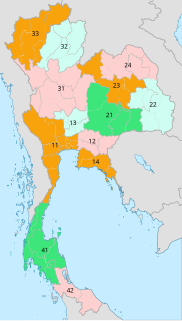
Central Thailand is one of the regions of Thailand, covering the broad alluvial plain of the Chao Phraya River. It is separated from northeast Thailand (Isan) by the Phetchabun mountain range. The Tenasserim Hills separate it from Myanmar to the west. In the north it is bounded by the Phi Pan Nam Range, one of the hilly systems of northern Thailand. The area was the heartland of the Ayutthaya Kingdom, and is still the dominant area of Thailand, containing as it does, the world's most primate city, Bangkok.Thailand has a theater name nang this theater arts are made a puppet painted buffalo hide.
Nakhon Ratchasima is one of Thailand's seventy-six provinces (changwat) lies in lower northeastern Thailand also called Isan. It is the country's largest province by area, has a population of approximately 2.7 million, and generates about 250 billion baht in GDP, the highest in Isan. Neighbouring provinces are Chaiyaphum, Khon Kaen, Buriram, Sa Kaeo, Prachinburi, Nakhon Nayok, Saraburi, and Lopburi.
Kanchanaburi is the largest of the western provinces (changwat) of Thailand. The neighboring provinces are Tak, Uthai Thani, Suphan Buri, Nakhon Pathom, and Ratchaburi. In the west it borders Kayin State, Mon State, and the Tanintharyi Region of Myanmar.
Phitsanulok Province, one of Thailand's seventy-six provinces, lies in lower northern Thailand. It borders Sukhothai and Uttaradit on the north, Loei and Phetchabun to the east, and Phichit and Kamphaeng Phet to the south. In the northeast it borders Laos.
Sukhothai is one of Thailand's seventy-six provinces (changwat) lies in lower northern Thailand. Neighboring provinces are Phrae, Uttaradit, Phitsanulok, Kamphaeng Phet, Tak, and Lampang. Sukhothai can be translated as 'dawn of happiness'.
Phetchabun is one of Thailand's seventy-six provinces (changwat) lies in lower northern Thailand. Neighbouring provinces are Loei, Khon Kaen, Chaiyaphum, Lopburi, Nakhon Sawan, Phichit, and Phitsanulok.
Uttaradit is one of Thailand's seventy-six provinces (changwat), lies in upper northern Thailand. Neighboring provinces are Phitsanulok, Sukhothai, Phrae and Nan. To the east it borders Xaignabouli of Laos. Uttaradit is 488 km north of Bangkok, and 238 km southeast of Chiang Mai.
The Phetchabun mountains are a mountain massif in Phetchabun, Phitsanulok, Loei and Chaiyaphum Provinces, Thailand. It consists of two parallel mountain chains, with the valley of the Pa Sak River in the middle.
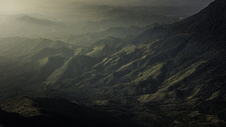
Northern Thailand is geographically characterised by several mountain ranges, which continue from the Shan Hills in bordering Myanmar to Laos, and the river valleys which cut through them. Though like most of Thailand, it has a tropical savanna climate, its relatively high elevation and latitude contribute to more pronounced seasonal temperature variation, with cooler winters than the other regions. Historically it is related to the Lanna Kingdom and its culture.
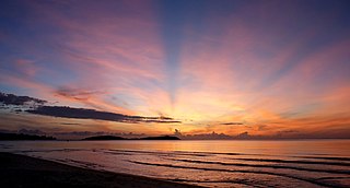
Southern Thailand is a southernmost cultural region of Thailand, separated from Central Thailand region by the Kra Isthmus.
Eastern Thailand is a region of Thailand bordering Cambodia on the east, Northeastern Thailand in the north, and central Thailand on the west.
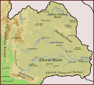
Dong Phaya Yen or Dong Phya Yen is a mountain range in Phetchabun, Chaiyaphum, Lopburi, Saraburi, and Nakhon Ratchasima Provinces, Thailand.
Phu Hin Rong Kla National Park is a national park located in the Loei, Phitsanulok and Phetchabun Provinces of Thailand. The protected area is located in the forested mountains of the Luang Prabang Range close to the border with Laos and is part of the Luang Prabang montane rain forests ecoregion. The park was the base of operations of the long fight of Thai combatant in communist war of Thailand.
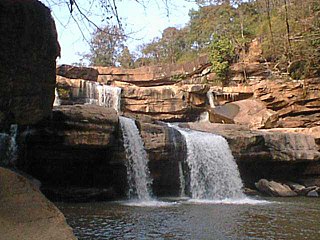
Thung Salaeng Luang National Park is a 1,262 km2 (487 sq mi) national park in Phitsanulok and Phetchabun Provinces of Thailand. It encompasses substantial portions of Wang Thong and Lom Sak Districts.
Namtok Chat Trakan National Park is a national park located in Chat Trakan and Nakhon Thai Districts of Phitsanulok Province of Thailand, established in 1987. It encompasses Lam Kwae Noi, Daeng and Chat Trakan forests a substantial portion of Chat Trakan District.
The Khao Kho National park is located in Lom Kao, Lom Sak, Khao Kho and Mueang Phetchabun districts in Phetchabun province.
Phu Soi Dao National Park, named after 2,120 m high Phu Soi Dao mountain, is a protected area at the southern end of the Luang Prabang Range in the Thai/Lao border area, on the Thai side of the range. It is located in Nam Pat District of Uttaradit Province and Chat Trakan District of Phitsanulok Province. The park was established as Thailand's 109th national park in 2008.
Phu Thap Boek is a 1,768 m high mountain in Phetchabun Province, Thailand near the border with Loei Province. It is in the Lom Kao District.
Military provinces of Thailand are subdivisions of the Royal Thai Army. Each military province governs and supports all military units and personnel in its area. Several military provinces are grouped into a military region. A military province can cover one or more civil provinces.