Punta Gabarró

Last updated
Punta Gabarró

Punta de Gabarro.JPG

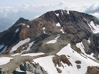
Punta Gabarró seen from Pica d'Estats
Highest point
Elevation 3,105 m (10,187 ft)
Coordinates 42°40′4.919″N1°23′48.75″E / 42.66803306°N 1.3968750°E / 42.66803306; 1.3968750 Coordinates: 42°40′4.919″N1°23′48.75″E / 42.66803306°N 1.3968750°E / 42.66803306; 1.3968750
Geography
Pyrenees topographic map-en.svg
Red triangle with thick white border.svg
Punta Gabarró
Location in the Pyrenees
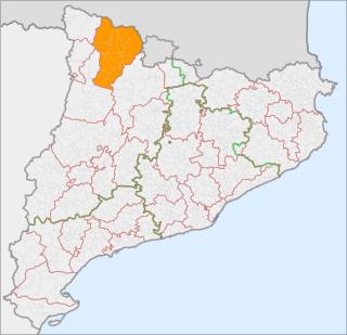
Location

Ariège, France

Pallars Sobirà, Spain
Parent range Montcalm Massif, Pyrenees
Geology
Mountain type Granite
Climbing
First ascent Unknown
Easiest route From Vallferrera, Alins

Punta Gabarró or Punta de Gabarró is a mountain of the Montcalm Massif. Located in the Pyrenees, at the border between France and Spain, it has an elevation of 3,105 metres (10,187 ft) above sea level. [1]

Montcalm Massif mountain in the Pyrenees, France and Spain

The Montcalm Massif is a mountain massif located in the Pyrenees, at the border between France and Spain, it has an altitude of 3077 metres above sea level.

Pyrenees Range of mountains in southwest Europe

The Pyrenees is a range of mountains in southwest Europe that forms a natural border between Spain and France. Reaching a height of 3,404 metres (11,168 ft) altitude at the peak of Aneto, the range separates the Iberian Peninsula from the rest of continental Europe, and extends for about 491 km (305 mi) from the Bay of Biscay to the Mediterranean Sea.

France Republic with mainland in Europe and numerous oversea territories

France, officially the French Republic, is a country whose territory consists of metropolitan France in Western Europe and several overseas regions and territories. The metropolitan area of France extends from the Mediterranean Sea to the English Channel and the North Sea, and from the Rhine to the Atlantic Ocean. It is bordered by Belgium, Luxembourg and Germany to the northeast, Switzerland and Italy to the east, and Andorra and Spain to the south. The overseas territories include French Guiana in South America and several islands in the Atlantic, Pacific and Indian oceans. The country's 18 integral regions span a combined area of 643,801 square kilometres (248,573 sq mi) and a total population of 67.3 million. France, a sovereign state, is a unitary semi-presidential republic with its capital in Paris, the country's largest city and main cultural and commercial centre. Other major urban areas include Lyon, Marseille, Toulouse, Bordeaux, Lille and Nice.

Contents

This peak was named after Pere Gabarró i Garcia, a Catalan mountaineer who found a new route to climb the Pica d'Estats. [2]

Pica dEstats mountain

Pica d'Estats is a 3,143-metre-high (10,312 ft) mountain in the Montcalm Massif, Pyrenees. on the Spanish–French border, and is the highest mountain in Catalonia.

This mountain is included in the Parc Natural de l'Alt Pirineu together with Pica d'Estats and Pic Verdaguer.

Pic Verdaguer mountain in France

Pic Verdaguer or Pic de Verdaguer is a mountain of the Montcalm Massif. Located in the Pyrenees, at the border between France and Spain, it has an altitude of 3,129 metres (10,266 ft) above sea level.

See also

Related Research Articles

Pallars Sobirà Comarca in Catalonia, Spain

Pallars Sobirà is a comarca in the mountainous northwest of Catalonia, Spain. The name means "Upper Pallars", distinguishing it from the more populous Pallars Jussà to its southwest. Its capital and largest municipality is Sort.

Alins Municipality in Catalonia, Spain

Alins is a municipality in the comarca of the Pallars Sobirà in Catalonia, Spain. It adjoins France and Andorra. It covers the valleys of the Noguera de Vallferrara and Tor rivers in the north of the comarca. The Pica d'Estats is part of the Montcalm Massif on the frontier between this municipality and Ariège, France. A local road links the municipality with the L-504 road.

Estat Català

Estat Català is a pro-independence nationalist historical political party of Catalonia (Spain).

Outline of Catalonia Overview of and topical guide to Catalonia

The following outline is provided as an overview of and topical guide to Catalonia:

Rodó de Canalbona mountain in France

Rodó de Canalbona or Pic Rodó de Canalbona is a mountain of Catalonia. Located in the Montcalm Massif, Pyrenees, at the border between France and Spain, it has an altitude of 3004 metres above sea level.

Pic de Canalbona mountain in France

Pic de Canalbona is a mountain of Catalonia, Spain. Located in the Montcalm Massif, Pyrenees, it has an altitude of 2,965 metres (9,728 ft) above sea level.

Serra de la Llena mountain in Spain

Serra de la Llena, also known as Serra la Llena, is a mountain chain straddling the municipal terms of Vilanova de Prades, La Pobla de Cérvoles (Garrigues) and Ulldemolins (Priorat), in Catalonia, Spain. These mountains have characteristic large and rounded rocky outcrops.

Prades Mountains mountain in Spain

Prades Mountains, also known as Muntanyes de Prades, is a large calcareous mountain massif straddling the comarcas of Alt Camp, Baix Camp, Conca de Barberà, Garrigues and Priorat, in Catalonia, Spain. They are a Site of Community Importance.

2012 Catalan independence demonstration protest march which occurred in Barcelon, Spain, on 11 September 2012

The 2012 Catalan independence demonstration was a protest march which occurred in central Barcelona in Catalonia, Spain, on 11 September 2012 during the National Day of Catalonia. The protestors demanded the independence of Catalonia and its establishment as a sovereign state under the slogan "Catalonia, new state in Europe". It was organized by the Catalan National Assembly (ANC) and headed together with the Association of Municipalities for Independence as the final and the most prominent of a series of events known as "March towards Independence" which began on 30 June 2012 in Lleida.

The Free Catalan Territory are those declared municipalities or regions of Catalonia that had approved a motion in a plenary session by the councillors of the town or the region council, as they represent the municipality's local authority. Such motions declare that Spanish laws and regulations are considered provisional, waiting for the Government and Parliament of Catalonia to enact new Catalan laws after having assumed national sovereignty, and therefore turning Catalonia into an independent state.

Pic de Montcalm mountain

Pic de Montcalm is a French pyrenean summit, culminating at 3,077 m (10,095 ft), located in the Ariège department, Midi-Pyrénées region of France.

Committee Pro Catalonia was a Catalan political committee founded on July 8, 1918 to support the actions of the Catalan National Committee in Paris to achieve an official Catalan representation in the League of Nations. It was chaired by Vicenç Albert Ballester and Pere Oliver i Domenge with Francesc Macià, Manuel Folguera i Duran, J. Grant i Sala as leading participants. It counted with the support of Unió Catalanista party, and maintained contacts with members of the Lliga Regionalista. Most of its members integrated into the Federació Democràtica Nacionalista, and later on into the Estat Català party.

Institut Nova Història

The Institut Nova Història (INH) is a Catalan cultural foundation with headquarters in Barcelona. Its members, of which the most prominent is the Catalan nationalist writer Jordi Bilbeny, hold that history has been systematically manipulated by the Spanish state since the 15th century to eliminate the Catalan contribution to world history. They claim that major historical figures, including Christopher Columbus, Erasmus, Miguel de Cervantes, William Shakespeare, Leonardo da Vinci, Saint Teresa of Ávila and others were Catalans whose identities have been manipulated by wicked minions of the Spanish Government. The institute's work has been criticised as pseudohistory, and not a single professional historian has endorsed its work.

Pere Aragonès Catalan politician

Pere Aragonès i Garcia is a Catalan lawyer, academic, politician and the current Vice President and Minister of Economy and Finance of Catalonia.

References

  1. "Mapa Topogràfic de Catalunya". Institut Cartogràfic de Catalunya. Retrieved May 22, 2010..
  2. Acadèmia de Ciències Mèdiques i de la Salut de Catalunya i de Balears, Pere Gabarró i Garcia, l’home