Balussery, also spelt as Balusseri, Balisseri or Balussheri) is a small but developing town area located in Kozhikode district in Kerala state, south India.

Thikkodi is a small village in Kozhikode district of Kerala state, south India. Thikkodi is famous for a coconut nursery, which is 100 years old. The nearest city is Kozhikode, which is 35 km from this village.
Koyilandy is a municipality in the taluk of the same name in Kozhikode district, Kerala on the Malabar Coast. The town is located between Kozhikode (Calicut) and Vadakara (Badagara) on National Highway 66.. Koyilandy is sometimes identified with Tyndis in Periplus of the Erythraean Sea.
Cheriyamundam is a panchayath of Tirur Taluk in Kerala, India. It covers an area of 11.95 km2 and includes 25,760 (1991) inhabitants. It lies near the Tirur River.
Katameri is a small village near Vatakara, Kozhikode district in Kerala, India. It is around 14 km east from Vatakara. Katameri is a part of Ayancherry Panchayat. It is under Kuttiyadi assembly constitution. There are many educational institutions in Katameri.

Muchukunnu is a small village on the Malabar Coast of south-western India.
Meppayur is a town in Kozhikode district of Kerala state, South India.

Perambra is a small city in Koyilandy taluk of Kozhikode district in North Malabar region of Kerala state, India.There is a high demand from people to allow Perambra as a Taluk and Municipality.It is one of the 140 assembly constituencies in Kerala, and one of the 12 block Panchayats in Kozhikode district. Perambra lies almost at the centre of the district.
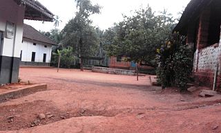
Vattoli Bazaar is a small town situated 2 km east of Balusseri in the Koyilandy -Thamarassery state highway. The location is in Kozhikode district of Kerala state in INdia.
Kottur is a grama panchayat and a community development block in the Kozhikode district of Kerala, India.

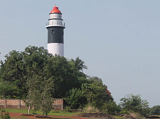
Thiruvangoor is a small village 16 kilometres (9.9 mi) away from Kozhikode, Kerala, India. It lies to the east of the Arabian Sea (Kappad) and west of Kuniyil Kadavu. Portuguese navigator Vasco de Gama is believed to have landed near Thiruvangoor, at Kappad, during one of his voyages, on 20 May 1498. Thiruvangoor sits on a national highway. Nearby major towns are Atholi and Koyilandy. The Kuniyil Kadavu Bridge allows for transportation between Thiruvangoor and Atholi town.
Eravattur is a village in Kozhikode district in the state of Kerala, India.
Nochad is a village in Kozhikode district in the state of Kerala, India which is part of Perambra Town.
Ulliyeri is a village in Kozhikode district in the state of Kerala, India.
Valayam is a village in Kozhikode district in the state of Kerala, India.
Valiacode is a small village of kozhikode district in nochad gramapanchayath. It is in Perambra assembly constituency and Vatakara Lok sabha constituency.
Cheruvannur one of the 78 grama panchayats of Kozhikode district, lies between North Latitude 11° 32′ 37.11" and 11° 36′ 4.67", East Longitude 75° 40′ 26.32" and 75° 43′ 55.22". It has a total area of 21.61 square kilometers. The adjoining grama panchayats are Thiruvallur and Velom in the north, Perambra in the east, Nochad, Meppayur, and Thurayur in the south, Maniyur and Thiruvallur in the west.
Nambrathkara is situated 4 km away from Koyilandy in the Indian state of Kerala.
Narippatta is a village and a Grama Panchayath in the north of Kozhikode district, Kerala, India.
Kadiyangad is a village in Kozhikode district, Kerala.