
Salem Street Burying Ground is a cemetery located at the intersection of Salem Street and Riverside Avenue in Medford, Massachusetts. The Salem Street Burying Ground was used exclusively from the late 17th century to the late 19th century for the burial of the town's wealthy. The cemetery was listed on the National Register of Historic Places in 1981.

The Hurricane of 1928 African-American Mass Burial Site is a pauper's cemetery and mass grave in West Palm Beach, Florida. It is listed on the U.S. National Register of Historic Places. The cemetery is situated near the junction of 25th Street and Tamarind Avenue between I-95 and U.S. Route 1. The site is the location in which 674 bodies of African Americans or those of an unknown race were buried following the 1928 Okeechobee hurricane, while most of the white victims of the storm received a proper burial at Woodlawn Cemetery due to segregation laws.

The Miami City Cemetery is a historic cemetery in Miami, Florida, United States. It is located at 1800 Northeast 2nd Avenue. On January 4, 1989, it was added to the U.S. National Register of Historic Places.
Stony Brook Meeting House and Cemetery are historic Quaker sites located at the Stony Brook Settlement at the intersection of Princeton Pike/Mercer Road and Quaker Road in Princeton, New Jersey, United States. The first Europeans to settle in the Princeton area were six Quaker families who built their homes near the Stony Brook around 1696. In 1709 Benjamin Clark deeded nine and three-fifths acres in trust to Richard Stockton and others to establish a Friends meeting house and burial ground.

The Arch Street Friends Meeting House, at 320 Arch Street at the corner of 4th Street in the Old City neighborhood of Philadelphia, Pennsylvania, is a Meeting House of the Religious Society of Friends (Quakers). Built to reflect Friends’ testimonies of simplicity and equality, this building is little changed after more than two centuries of continuous use.

Cole's Hill is a National Historic Landmark containing the first cemetery used by the Mayflower Pilgrims in Plymouth, Massachusetts in 1620. The hill is located on Carver Street near the foot of Leyden Street and across the street from Plymouth Rock. Owned since 1820 by the preservationist Pilgrim Society, it is now a public park.

The First Burial Ground or Park Street Burial Ground is a historic cemetery on Park Street near Centre Street in Woburn, Massachusetts. Established c. 1646, it is the city's first and oldest cemetery. It occupies a 1.4-acre (0.57 ha) parcel at the corner of Park and Centre Streets near Woburn Square. Most of the burials took place before 1794, and are marked by slate headstones. The last documented burial took place in 1903. In a manner typical of early colonial cemeteries, there is no formal circulation pattern, and graves are not laid out in any formal, organized manner.

Amherst West Cemetery is a historic cemetery on Triangle Street in Amherst, Massachusetts. The 4 acres (1.6 ha) cemetery was first laid out in 1730, when the voters of Hadley elected to establish a new burying ground in its eastern precinct. When the area was separated as Amherst in 1786, the property was taken over by the newly established town. In addition to being the burial site of many of Amherst's early settlers and American Civil War veterans, it is also the burial site of members of the Dickinson family, most notably the poet Emily Dickinson. Their family plot is set off from the rest of the cemetery by a wrought iron fence.

The East Main Street Cemetery is a historic cemetery on East Main Street in Dalton, Massachusetts. The cemetery is one of the oldest in the town, with grave markers dating to the 1780s. It was founded on land owned by the Chamberlin family, whose identified graves make up about 20 percent of roughly 250 gravesites. The cemetery was listed on the National Register of Historic Places in 2000.

The Myles Standish Burial Ground in Duxbury, Massachusetts is, according to the American Cemetery Association, the oldest maintained cemetery in the United States.
Burial Hill is a historic cemetery or burying ground on School Street in Plymouth, Massachusetts. Established in the 17th century, it is the burial site of several Pilgrims, the founding settlers of Plymouth Colony. It was listed on the National Register of Historic Places in 2013.

Slate Hill Burying Ground is a historic cemetery in Lower Makefield Township, Pennsylvania, with most of its graves dating to 18th century Quaker settlers. It is located at Yardley-Morrisville Road and Mahlon Drive.

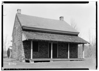
The Signer's House and Matthew Thornton Cemetery are a pair of historic properties in Merrimack, New Hampshire, United States. It consists of a house, once owned by Matthew Thornton, a signer of the United States Declaration of Independence, and the adjacent cemetery in which he is buried. The house is a two-story Georgian style double house, and is the only surviving house of the period in Merrimack. It was owned by Thornton from 1780 to 1797, when he sold it to his son James. The cemetery, located across the Daniel Webster Highway from the house, is also Merrimack's first cemetery, with the oldest gravestone marked 1742.

Kent Burying Ground is a historic cemetery at the corner of Fayette Corner Road and Oak Hill Road in Fayette, Maine. Established in 1880 by Elias Kent, it is unusual for its layout of concentric rings around a central monument, only known in one other cemetery in the state, the Wing Family Cemetery in nearby Wayne. The cemetery was listed on the National Register of Historic Places in 2008.

The Sharp Burial Ground, also known as the Albany Avenue Cemetery, is located on Albany Avenue in Kingston, New York, United States. It is a small burying ground used during the middle decades of the 19th century, before larger rural cemeteries had become common but after churchyards had become too full for further burials. Later, when they did open, many bodies were removed to consolidate them with larger family plots there. Two former congressmen are still among those buried at Sharp.

Kinne Cemetery, also known as the Glasgo Cemetery and Old Kinne Burying Ground, is a historic cemetery in Jarvis Road in Griswold, Connecticut. The earliest marked stone is for Daniel Kinne who died in 1713. In the 1930s, the inscriptions of 79 stones in the Kinne Cemetery were recorded for the Hale Index. There are around 80 fieldstones with no carving or identification, but it is unknown if this stems from wearing of the gneiss stone or that there were no skilled carvers locally available. The seven carvers that have been identified are Lebbeus Kimball, Jotham Warren, Josiah Manning, Peter Barker, Mr. Huntington of Lebanon, E. Marston of Mystic Bridge and O. Doty of Stonington. The National Historic Register of Places nomination notes, "the cemetery is significant artistically because the carving on the stones gives many good examples of the funerary art that was characteristic of the 18th and 19th centuries in New England." The cemetery is notable because of the burial of Isaac C. Glasko, the namesake of the village of Glasgo, and a prominent African American land-holding man who ran a blacksmith shop that was important to the marine industry of the area. The cemetery was made a part of the Connecticut Freedom Trail in 1995 and it was added to the National Register of Historic Places on April 12, 2001.

The First Parish Burial Ground is a historic cemetery located at 122 Centennial Avenue in Gloucester, Massachusetts. Established in 1644, the 2.5 acres (1.0 ha) site is Gloucester's oldest burying ground. It once stood at the heart of the Gloucester settlement, and was for 80 years its only cemetery. It was listed on the National Register of Historic Places in 1975. It is now being maintained jointly by the city and the Cemetery Restoration Partnership.

The Old North Cemetery is the oldest cemetery in Truro, Massachusetts. The cemetery, formerly the Old North Graveyard, was established in 1713 on the Hill of Storms where the first church in Truro was built in 1709. It remained the town's only cemetery until 1799 when the Pine Grove Cemetery was established. Old North is on US Route 6 between Aldrich Road and South Highland Road. Many individuals associated with Truro's early development are buried here, as are ship's captains. When originally laid out, the cemetery was about 3 acres (1.2 ha) in size; it was expanded in 1926 and again in 1974 and is now 5.8 acres. The oldest part of the cemetery is its northernmost section, abutting Aldrich Road. As of 2022 there are approximately 1,670 burials in the cemetery. Over half of those buried in the original "Old Stone" (north) section were less than 50 years old when they died.

The Old Scots Burying Ground is a historic cemetery located on Gordon's Corner Road in the Wickatunk section of Marlboro Township, in Monmouth County, New Jersey. It was added to the National Register of Historic Places on August 15, 2001, for its significance in history and religion. The Old Scots Burying Ground is about an acre in size, about 195 feet above sea level and dates back to 1685. The total number of burials at the cemetery is not precisely known, suggested by Symms, "There are a large number of graves in Old Scots yard without any inscribed stones". Some reports place the number as at least 100 known graves with most headstones of brown sandstone. However, more recent research using ground penetrating radar reported by the Old Tennent Church in 2001 has put the number of confirmed sites at about 122 graves with a possible 140 more unmarked; placing the number at about 262 total graves in the cemetery. In 1945, in an attempt to clean out the site of vegetation and over-growth, a bulldozer was used on the property and as a result some headstones were dislodged and broken stones removed. The defining structure in the cemetery is a tall monument to Rev. John Boyd, created by the J&R Lamb Company. Built to commemorate the first recorded Presbyterian ordination of Rev. John Boyd. The monument is currently owned by the Synod of the Northeast who holds the property deed but it is maintained by the Old Tennent Church. The last identified burial was in 1977.
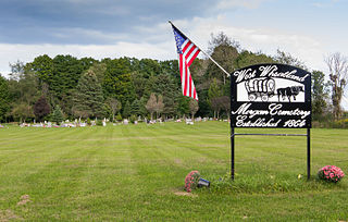
The Morgan West Wheatland Cemetery is a cemetery located on 55th Avenue between 10 & 11 Mile Roads in Wheatland Township, Mecosta County, Michigan. It was listed on the National Register of Historic Places in 2014.


